Jump to content

Պատկեր:Map of Sunda and Sahul.svg

Page contents not supported in other languages.
Վիքիպեդիայից՝ ազատ հանրագիտարանից

Սկզբնական նիշք(SVG-նիշք, անվանապես 976 × 907 փիքսել, նիշքի չափը՝ 845 ԿԲ)

Render this image in .

Այս նիշքը տեղադրված է Վիքիպահեստում է և այն կարող է օգտագործվել այլ նախագծերի կողմից։ Վիքիպահեստում նիշքի մասին տեղեկությունների հիմնական մասը ներկայացված է ստորև։

Ամփոփում

Description
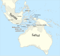
Català: Mapa de Sonda i Sahul (marcat per un contorn de 125 m de profunditat) i la Línia de Wallace, la Línia de Weber i la Línia de Lydekker.
English: Map of Sunda and Sahul (marked by 125m depth contour) and the Wallace Line, the Weber Line and the Lydekker Line.
Key
InfoField
 
sea
 
current land extent (0BP)
 
land extent at Last Glacial Maximum (23000+-3000 BP)
Թվական
Աղբյուր

Բեռնողի սեփական աշխատանք, based on file:map of Sunda and Sahul.png and using

Ստեղծել է
 Geotemporal data
Spatial reference system equirectangular
Bounding box
N: 20.2°N
W: 91°E E: 162.8°E
S: 45°S
Այլ մեկնակերպներ
Other related versions: Map of Sunda and Sahul.png


Translate this file

Այս SVG ֆայլ օգտագործում է զետեղված տեքստ, որը կարելի է հեշտ թարգմանել ձեր լեզվի վրա using [toolforge:svgtranslate/File:Map_of_Sunda_and_Sahul.svglink this automated tool]: Իմացեք ավելին: You can also download it and translate it manually using a text editor.

This file is translated using SVG <switch> elements. All translations are stored in the same file! Learn more.

For most Wikipedia projects, you can embed the file normally (without a lang parameter). The Wikipedia will use its language if the SVG file supports that language. For example, the German Wikipedia will use German if the SVG file has German. To embed this file in a particular language use the lang parameter with the appropriate language code, e.g. [[File:Map of Sunda and Sahul.svg|lang=en]] for the English version. Do not specify a lang parameter if it is not needed. The parameter may prevent the use of a subsequent translation.

To translate the text into your language, you can use the SVG Translate tool. Alternatively, you can download the file to your computer, add your translations using whatever software you're familiar with, and re-upload it with the same name. You will find help in Graphics Lab if you're not sure how to do this.

Արտոնագրում

Ես, այս աշխատանքի հեղինակային իրավունքների տերը, ներկա հրատարակում եմ սրա հետևյալ լիցենզիաների պայմաններով
w:en:Creative Commons
հղում համանման տարածում
This file is licensed under the Creative Commons Attribution-Share Alike 4.0 International license.
Դուք ազատ եք՝
  • կիսվել ստեղծագործությամբ – պատճենել, տարածել և փոխանցել այս աշխատանքը։
  • վերափոխել – ադապտացնել աշխատանքը
Պահպանելով հետևյալ պայմանները'
  • հղում – Դուք պետք է նշեք հեղինակի (իրավատիրոջ) հղումը:
  • համանման տարածում – Եթե դուք ձևափոխում եք, փոխակերպում, կամ այս աշխատանքի հիման վրա ստեղծում եք նոր աշխատանք, ապա ձեր ստեղծածը կարող է տարածվել միայն նույն կամ համարժեք թույլատրագրով։
GNU head Այս վավերագրման պատճենահանման, տարածման և/կամ ձևափոխման թույլտվություն կամ լիցենզիայի GNU FDL պայմաններով 1.2 մեկնակերպի կամ ավելի ուշ, հրատարակված Ազատ ծրագրային ապահովության հիմնադրամում, առանց անփոփոխելի հատվածների, առանց բնագիրների, որոնք տեղադրված են առաջին և վերջին շապիկներում: Լիցենզիայի պատճենը գտնվում է GNU Free Documentation License հատվածում:
Կարող եք ընտրել այս թույլատրագրերից ցանկացածը։

Captions

Add a one-line explanation of what this file represents

Items portrayed in this file

պատկերված

Նիշքի պատմություն

Մատնահարեք օրվան/ժամին՝ նիշքի այդ պահին տեսքը դիտելու համար։

Օր/ԺամՄանրապատկերՕբյեկտի չափըՄասնակիցՄեկնաբանություն
ընթացիկ23:42, 12 Ապրիլի 202423:42, 12 Ապրիլի 2024 տարբերակի մանրապատկերը976 × 907 (845 ԿԲ)ManlleusFile uploaded using svgtranslate tool (https://svgtranslate.toolforge.org/). Added translation for ca.
23:34, 12 Ապրիլի 202423:34, 12 Ապրիլի 2024 տարբերակի մանրապատկերը976 × 907 (845 ԿԲ)ManlleusFile uploaded using svgtranslate tool (https://svgtranslate.toolforge.org/). Added translation for ca.
15:07, 16 հունվարի 202315:07, 16 հունվարի 2023 տարբերակի մանրապատկերը976 × 907 (841 ԿԲ)Kanguole{{Map |Description={{en|Map of Sunda and Sahul (marked by 125m depth contour) and the Wallace Line, the Weber Line and the Lydekker Line.}} |Projection=equirectangular |Latitude=-45/20.2 |Longitude=91/162.8 |Warp status=skip |Source={{own}}, using * Coastline from [http://www.naturalearthdata.com/downloads/50m-physical-vectors/ Natural Earth 1:50m Physical Vectors] * 125m depth contour derived...

Հետևյալ 2 էջերը հղվում են այս նիշքին՝

Նիշքի համընդհանուր օգտագործում

Հետևյալ այլ վիքիները օգտագործում են այս նիշքը՝

Մետատվյալներ