
Պատկեր:Lancashire UK locator map 2010.svg

Size of this PNG preview of this SVG file: 494 × 600 պիքսել. Այլ թույլտվությաններ: 198 × 240 պիքսել | 395 × 480 պիքսել | 633 × 768 պիքսել | 843 × 1024 պիքսել | 1687 × 2048 պիքսել | 1108 × 1345 պիքսել.
Սկզբնական նիշք (SVG-նիշք, անվանապես 1108 × 1345 փիքսել, նիշքի չափը՝ 302 ԿԲ)
Юююююю .
Че
Ամփոփում
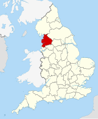
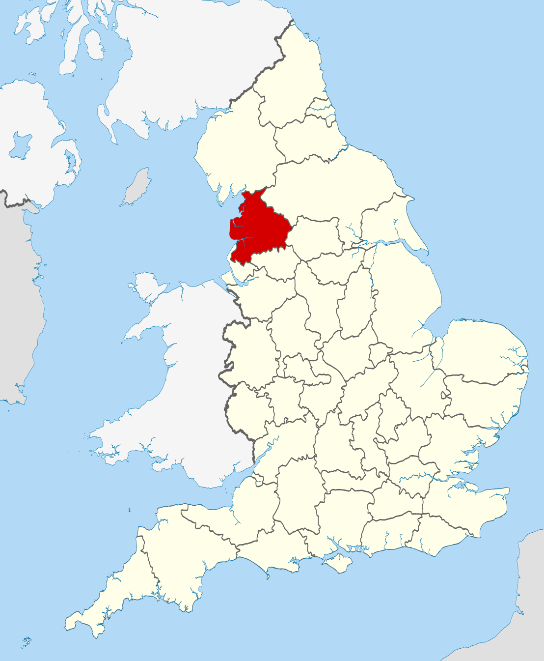
| Նկարագրում | Location of the ceremonial county of Lancashire within England. |
| Թվական | |
| Աղբյուր |
National Geospatial-Intelligence Agency
|
| Հեղինակ | Nilfanion |
Արտոնագրում
Ես, այս աշխատանքի հեղինակային իրավունքների տերը, ներկա հրատարակում եմ սրա հետևյալ լիցենզիաների պայմաններով
Այս նիշքը հասանելի է Creative Commons Attribution-Share Alike 3.0 Unported արտոնագրի ներքո:
- Դուք ազատ եք՝
- կիսվել ստեղծագործությամբ – պատճենել, տարածել և փոխանցել այս աշխատանքը։
- վերափոխել – ադապտացնել աշխատանքը
- Պահպանելով հետևյալ պայմանները'
- հղում – Դուք պետք է նշեք հեղինակի (իրավատիրոջ) հղումը:
- համանման տարածում – Եթե դուք ձևափոխում եք, փոխակերպում, կամ այս աշխատանքի հիման վրա ստեղծում եք նոր աշխատանք, ապա ձեր ստեղծածը կարող է տարածվել միայն նույն կամ համարժեք թույլատրագրով։

|
Այս վավերագրման պատճենահանման, տարածման և/կամ ձևափոխման թույլտվություն կամ լիցենզիայի GNU FDL պայմաններով 1.2 մեկնակերպի կամ ավելի ուշ, հրատարակված Ազատ ծրագրային ապահովության հիմնադրամում, առանց անփոփոխելի հատվածների, առանց բնագիրների, որոնք տեղադրված են առաջին և վերջին շապիկներում: Լիցենզիայի պատճենը գտնվում է GNU Free Documentation License հատվածում: |
Կարող եք ընտրել այս թույլատրագրերից ցանկացածը։

|
This is one of the images forming part of the Valued image set: Locator maps of the Ceremonial counties of England on Wikimedia Commons. The image set has been assessed under the valued image set criteria and is considered the most valued set on Commons within the scope:
Locator maps of the Ceremonial counties of England
You can see its nomination at Commons:Valued image candidates/Locator maps of English ceremonial counties. |
Նիշքի պատմություն
Մատնահարեք օրվան/ժամին՝ նիշքի այդ պահին տեսքը դիտելու համար։
| Օր/Ժամ | Մանրապատկեր | Օբյեկտի չափը | Մասնակից | Մեկնաբանություն | |
|---|---|---|---|---|---|
| ընթացիկ | 22:39, 23 Նոյեմբերի 2010 | | 1108 × 1345 (302 ԿԲ) | Nilfanion | == Summary == {{Information |Description=Location of the ceremonial county of Lancashire within England. |Source=Ordnance Survey [https://www.ordnancesurvey.co.uk/opendatadownload/products.html OpenData]: *County bou |
Նիշքի օգտագործում
Հետևյալ էջը հղվում է այս նիշքին՝
Նիշքի համընդհանուր օգտագործում
Հետևյալ այլ վիքիները օգտագործում են այս նիշքը՝
- Օգտագործումը af.wikipedia.org կայքում
- Օգտագործումը ar.wikipedia.org կայքում
- Օգտագործումը ast.wikipedia.org կայքում
- Օգտագործումը az.wikipedia.org կայքում
- Օգտագործումը be-tarask.wikipedia.org կայքում
- Օգտագործումը be.wikipedia.org կայքում
- Օգտագործումը bg.wikipedia.org կայքում
- Օգտագործումը br.wikipedia.org կայքում
- Օգտագործումը ca.wikipedia.org կայքում
- Օգտագործումը ceb.wikipedia.org կայքում
- Օգտագործումը cs.wikipedia.org կայքում
- Օգտագործումը en.wikipedia.org կայքում
- Lancashire
- National nature reserves in Lancashire
- Grit Fell
- Wolfhole Crag
- Fair Snape Fell
- Leyland Hundred
- Lonsdale Hundred
- Bleasdale
- Knott End-on-Sea
- Great Altcar
- Trawden
- White Hill (Forest of Bowland)
- Hawthornthwaite Fell
- Gambleside
- Brownhill
- Catforth
- Over Wyre
- Oakenshaw, Lancashire
- Langho
- River Tawd
- Downholland Cross
- Haskayne
- Farington
- Salwick
- Barrow Nook
- Foulridge
- Wennington, Lancashire
- Template:Lancashire-geo-stub
- Eagland Hill
- Yarrow Valley Country Park
- Quernmore
- Central Lancashire
- Whittington, Lancashire
- River Hyndburn
- Barley-with-Wheatley Booth
- Barnacre-with-Bonds
- Bickerstaffe
- Municipal Borough of Morecambe and Heysham
Տեսնել այս նիշքի ավելի համընդհանուր օգտագործումը: