
Պատկեր:Warming Island USGS Landsat.jpg
Ավելի բարձր կետաչափով տարբերակ չկա։
Warming_Island_USGS_Landsat.jpg (800 × 262 փիքսել, նիշքի չափը՝ 56 ԿԲ, MIME-տեսակը՝ image/jpeg)
| Նկարագրում |
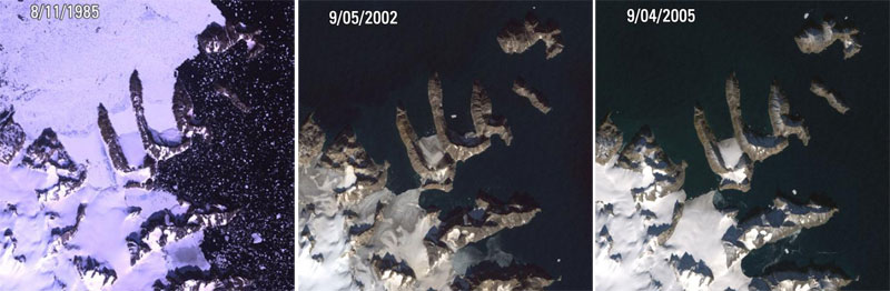
Warming Island, Greenland L5, L7 ETM+ Acquisition Date: Aug 11, 1985 & Sep 05, 2002 & Sep 04, 2005 Path/Row: 227/9 Lat/Long: 72.207/-22.180 On January 16th, 2007, the New York Times reported that a new island had been found in Greenland. Warming Island was once thought to be an ice-covered peninsula, but it was exposed as an island when a glacier melted to reveal the strait. This image shows satellite pictures of the island in 1985 when the glacier had firmly tied it to the mainland, in 2002 when there was only a thin bridge of ice, and in 2005 when the bridge of ice has broken to reveal an open water strait. More islands like this may be discovered if the Greenland ice sheet continues to disappear. |
| Թվական | 1985 - 2005 |
| Աղբյուր |
|
| Հեղինակ | USGS Landsat |
| Իրավունքներ (Նիշքի վերաօգտագործումը) |
PD-USGov-Interior-USGS |
This image is in the public domain in the United States because it only contains materials that originally came from the United States Geological Survey, an agency of the United States Department of the Interior. For more information, see the official USGS copyright policy.
|
Նիշքի պատմություն
Մատնահարեք օրվան/ժամին՝ նիշքի այդ պահին տեսքը դիտելու համար։
| Օր/Ժամ | Մանրապատկեր | Օբյեկտի չափը | Մասնակից | Մեկնաբանություն | |
|---|---|---|---|---|---|
| ընթացիկ | 21:15, 3 Դեկտեմբերի 2008 | 800 × 262 (56 ԿԲ) | RaviC | {{Information |Description=Warming Island, Greenland L5, L7 ETM+ Acquisition Date: Aug 11, 1985 & Sep 05, 2002 & Sep 04, 2005 Path/Row: 227/9 Lat/Long: 72.207/-22.180 On January 16th, 2007, the New York Times reported that a new island had been found in |
Նիշքի օգտագործում
Հետևյալ էջը հղվում է այս նիշքին՝
Նիշքի համընդհանուր օգտագործում
Հետևյալ այլ վիքիները օգտագործում են այս նիշքը՝
- Օգտագործումը ar.wikipedia.org կայքում
- Օգտագործումը az.wikipedia.org կայքում
- Օգտագործումը en.wikipedia.org կայքում
- Օգտագործումը es.wikipedia.org կայքում
- Օգտագործումը it.wikipedia.org կայքում
- Օգտագործումը ja.wikipedia.org կայքում
- Օգտագործումը nl.wikipedia.org կայքում
- Օգտագործումը pl.wikipedia.org կայքում
- Օգտագործումը ru.wikipedia.org կայքում
- Օգտագործումը uk.wikipedia.org կայքում
- Օգտագործումը vi.wikipedia.org կայքում