
Պատկեր:Virginia geographic map-en.svg

Size of this PNG preview of this SVG file: 800 × 439 պիքսել. Այլ թույլտվությաններ: 320 × 176 պիքսել | 640 × 352 պիքսել | 1024 × 562 պիքսել | 1280 × 703 պիքսել | 2560 × 1406 պիքսել | 3641 × 2000 պիքսել.
Սկզբնական նիշք (SVG-նիշք, անվանապես 3641 × 2000 փիքսել, նիշքի չափը՝ 12,5 ՄԲ)
Ամփոփում
| Նկարագրում |
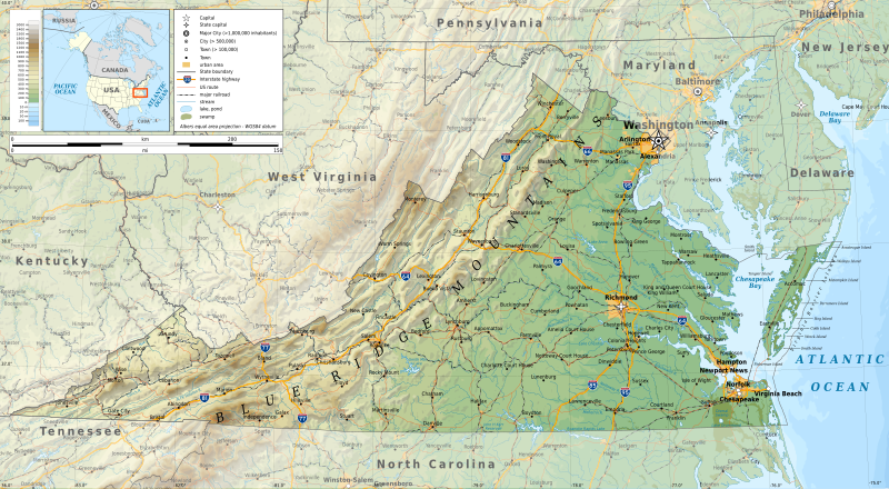
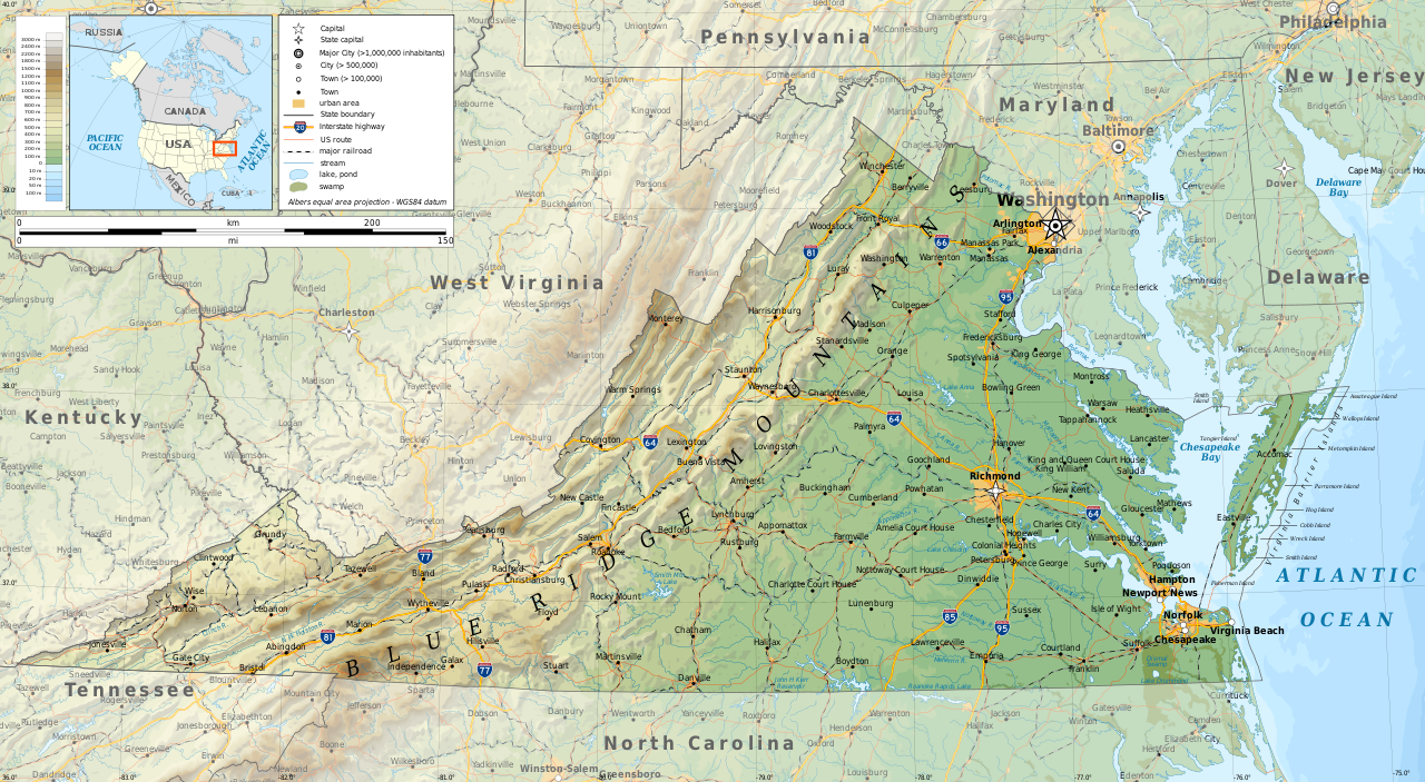
English: Geographic map of Virginia in English. Geographic limits of the map:
|
| Թվական | |
| Աղբյուր |
Բեռնողի սեփական աշխատանք
|
| Հեղինակ | Ikonact |
| Իրավունքներ (Նիշքի վերաօգտագործումը) |
Any use of this map is subject of the license(s) stated below with the condition that you credit (Wikimedia Commons user: Ikonact) as the author . A message with a reply address would also be greatly appreciated. |

|
Այս SVG ֆայլ օգտագործում է զետեղված տեքստ, որը կարելի է հեշտ թարգմանել ձեր լեզվի վրա using [toolforge:svgtranslate/File:Virginia_geographic_map-en.svglink this automated tool]: Իմացեք ավելին: You can also download it and translate it manually using a text editor. |
Արտոնագրում
Ես, սույն աշխատանքի հեղինակային իրավունքների տերը, այսուհետ այն հրատարակում եմ հետևյալ արտոնագրի ներքո։
This file is licensed under the Creative Commons Attribution-Share Alike 4.0 International license.
- Դուք ազատ եք՝
- կիսվել ստեղծագործությամբ – պատճենել, տարածել և փոխանցել այս աշխատանքը։
- վերափոխել – ադապտացնել աշխատանքը
- Պահպանելով հետևյալ պայմանները'
- հղում – Դուք պետք է նշեք հեղինակի (իրավատիրոջ) հղումը:
- համանման տարածում – Եթե դուք ձևափոխում եք, փոխակերպում, կամ այս աշխատանքի հիման վրա ստեղծում եք նոր աշխատանք, ապա ձեր ստեղծածը կարող է տարածվել միայն նույն կամ համարժեք թույլատրագրով։
Նիշքի պատմություն
Մատնահարեք օրվան/ժամին՝ նիշքի այդ պահին տեսքը դիտելու համար։
| Օր/Ժամ | Մանրապատկեր | Օբյեկտի չափը | Մասնակից | Մեկնաբանություն | |
|---|---|---|---|---|---|
| ընթացիկ | 10:08, 16 Սեպտեմբերի 2019 | | 3641 × 2000 (12,5 ՄԲ) | Ikonact | valid svg |
| 08:37, 16 Սեպտեմբերի 2019 |  | 3641 × 2000 (12,59 ՄԲ) | Ikonact | swamp pattern removed... librsvg bug with handling patterns at small sized pictures | |
| 22:08, 15 Սեպտեմբերի 2019 |  | 3641 × 2000 (13,38 ՄԲ) | Ikonact | some font issues | |
| 21:48, 15 Սեպտեմբերի 2019 |  | 3641 × 2000 (13,38 ՄԲ) | Ikonact | names added, size changed | |
| 22:08, 13 Սեպտեմբերի 2019 |  | 5461 × 3000 (12,2 ՄԲ) | Ikonact | =={{int:filedesc}}== {{Information |description={{en|1=Geographic map of Virginia. Geographic limits of the map:}} *N: 39.98° N *S: 36.00° N *W: 83.75° W *E: 74.80° W Albers equal area projection; WGS 84 datum |date=2019-09-14 |source={{own}} *Sources of data:<br/> **Topography: ETOPO1 (public domain);<br/> **Public domain data provided by the National Atlas of the United States of America;<br/> *Tool:<br/> **The map is created with Octave scripts developed by Ikonact |author... |
Նիշքի օգտագործում
Հետևյալ էջը հղվում է այս նիշքին՝
Նիշքի համընդհանուր օգտագործում
Հետևյալ այլ վիքիները օգտագործում են այս նիշքը՝
- Օգտագործումը ang.wikipedia.org կայքում
- Օգտագործումը be.wikipedia.org կայքում
- Օգտագործումը bg.wikipedia.org կայքում
- Օգտագործումը ca.wikipedia.org կայքում
- Օգտագործումը en.wikipedia.org կայքում
- Օգտագործումը ga.wikipedia.org կայքում
- Օգտագործումը gl.wikipedia.org կայքում
- Օգտագործումը hu.wikipedia.org կայքում
- Օգտագործումը lt.wikipedia.org կայքում
- Օգտագործումը mhr.wikipedia.org կայքում
- Օգտագործումը os.wikipedia.org կայքում
- Օգտագործումը ru.wikipedia.org կայքում
- Օգտագործումը tg.wikipedia.org կայքում
- Օգտագործումը tt.wikipedia.org կայքում
- Օգտագործումը www.wikidata.org կայքում