
Պատկեր:Trebizond1300.png
Ավելի բարձր կետաչափով տարբերակ չկա։
Trebizond1300.png (552 × 392 փիքսել, նիշքի չափը՝ 67 ԿԲ, MIME-տեսակը՝ image/png)
Ամփոփում
| Նկարագրում |
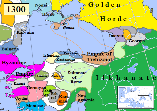
English: Map of the Trebizond Empire in Anatolia, AD 1300.
(Partially based on Euratlas map of Europe, 1300.) |
| Թվական | |
| Աղբյուր | Բեռնողի սեփական աշխատանք |
| Հեղինակ | Gabagool |

|
This historical map image could be re-created using vector graphics as an SVG file. This has several advantages; see Commons:Media for cleanup for more information. If an SVG form of this image is available, please upload it and afterwards replace this template with
{{vector version available|new image name}}.
It is recommended to name the SVG file “Trebizond1300.svg”—then the template Vector version available (or Vva) does not need the new image name parameter. |
Արտոնագրում
Ես, սույն աշխատանքի հեղինակային իրավունքների տերը, այսուհետ այն հրատարակում եմ հետևյալ արտոնագրի ներքո։
This file is licensed under the Creative Commons Attribution 3.0 Unported license.
- Դուք ազատ եք՝
- կիսվել ստեղծագործությամբ – պատճենել, տարածել և փոխանցել այս աշխատանքը։
- վերափոխել – ադապտացնել աշխատանքը
- Պահպանելով հետևյալ պայմանները'
- հղում – Դուք պետք է նշեք հեղինակի (իրավատիրոջ) հղումը:
Նիշքի պատմություն
Մատնահարեք օրվան/ժամին՝ նիշքի այդ պահին տեսքը դիտելու համար։
| Օր/Ժամ | Մանրապատկեր | Օբյեկտի չափը | Մասնակից | Մեկնաբանություն | |
|---|---|---|---|---|---|
| ընթացիկ | 15:21, 12 Օգոստոսի 2023 | | 552 × 392 (67 ԿԲ) | Gyalu22 | Reverted to version as of 16:24, 16 November 2022 (UTC) Wallachia was not part of the Second Bulgarian Empire, see https://www.google.com/search?q=europe+map+1300 |
| 15:09, 12 Մայիսի 2023 |  | 564 × 404 (143 ԿԲ) | Moodylo333 | Correct borders & states year 1300 | |
| 16:24, 16 Նոյեմբերի 2022 |  | 552 × 392 (67 ԿԲ) | Gyalu22 | Reverted to version as of 00:49, 13 December 2012 (UTC) | |
| 17:46, 15 Օգոստոսի 2019 |  | 552 × 392 (94 ԿԲ) | Georgiano | Reverted to version as of 17:44, 15 August 2019 (UTC) correct source: File:Map–Principality of Samtskhe till c.1325–ka.svg | |
| 17:45, 15 Օգոստոսի 2019 |  | 552 × 392 (89 ԿԲ) | Georgiano | Reverted to version as of 23:21, 2 April 2016 (UTC) | |
| 17:44, 15 Օգոստոսի 2019 |  | 552 × 392 (94 ԿԲ) | Georgiano | added Principality of Samtskhe (vassal of Ilkhanate between 1266–1334) source: File:Caucasus 1311 AD map de.png | |
| 23:21, 2 Ապրիլի 2016 |  | 552 × 392 (89 ԿԲ) | Julieta39 | Cosmetic work, add Amastris, Montecastro, Caffa & Cembalo (to Genoa) and some details according with Claude Mutafian & Eric Van Lauwe’s « Atlas Historique de l’Armenie », Paris, ed. Autrement 2001, ISBN 2-7467-0100-6 | |
| 20:06, 14 Մարտի 2016 |  | 552 × 392 (75 ԿԲ) | Georgiano | fixed borders of Georgian kingdoms | |
| 10:25, 17 Հուլիսի 2015 |  | 552 × 392 (89 ԿԲ) | Spiridon Ion Cepleanu | Little rectifications. according with H.E.Stier's (dir.) « Westermann Grosser Atlas zur Weltgeschichte », 1985, ISBN 3-14-100919-8 for the year 1300 | |
| 00:49, 13 Դեկտեմբերի 2012 |  | 552 × 392 (67 ԿԲ) | Geagea | Reverted to version as of 19:54, 30 March 2009 |
Նիշքի օգտագործում
Հետևյալ էջը հղվում է այս նիշքին՝
Նիշքի համընդհանուր օգտագործում
Հետևյալ այլ վիքիները օգտագործում են այս նիշքը՝
- Օգտագործումը ar.wikipedia.org կայքում
- Օգտագործումը azb.wikipedia.org կայքում
- Օգտագործումը az.wikipedia.org կայքում
- Օգտագործումը be.wikipedia.org կայքում
- Օգտագործումը bg.wikipedia.org կայքում
- Օգտագործումը cs.wikipedia.org կայքում
- Օգտագործումը diq.wikipedia.org կայքում
- Օգտագործումը dsb.wikipedia.org կայքում
- Օգտագործումը el.wikipedia.org կայքում
- Օգտագործումը en.wikipedia.org կայքում
- Օգտագործումը es.wikipedia.org կայքում
- Օգտագործումը et.wikipedia.org կայքում
- Օգտագործումը eu.wikipedia.org կայքում
- Օգտագործումը fa.wikipedia.org կայքում
- Օգտագործումը fiu-vro.wikipedia.org կայքում
- Օգտագործումը fr.wikipedia.org կայքում
- Օգտագործումը gl.wikipedia.org կայքում
- Օգտագործումը hr.wikipedia.org կայքում
- Օգտագործումը hu.wikipedia.org կայքում
- Օգտագործումը id.wikipedia.org կայքում
- Օգտագործումը it.wikipedia.org կայքում
- Օգտագործումը ka.wikipedia.org կայքում
- Օգտագործումը ku.wikipedia.org կայքում
- Օգտագործումը lt.wikipedia.org կայքում
- Օգտագործումը mk.wikipedia.org կայքում
- Օգտագործումը ms.wikipedia.org կայքում
- Օգտագործումը nl.wikipedia.org կայքում
Տեսնել այս նիշքի ավելի համընդհանուր օգտագործումը: