
Պատկեր:Overtoun Bridge - geograph.org.uk - 1024544.jpg
Overtoun_Bridge_-_geograph.org.uk_-_1024544.jpg (640 × 480 փիքսել, նիշքի չափը՝ 110 ԿԲ, MIME-տեսակը՝ image/jpeg)
Ամփոփում
| Նկարագրում |
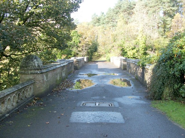
English: Overtoun Bridge. This thick-sided stone bridge, located next to 59380, has parapets on both sides; the river gorge that it crosses has sides that fall away steeply, and the river is therefore located a surprising distance below the bridge.
Overtoun House was built in 1859-63 for the Rutherglen chemical manufacturer James White (1735631), whose son became the first Lord Overtoun, but the bridge dates from 1895, and was built by H.E.Milner ["North Clyde Estuary - An Illustrated Architectural Guide", Frank Arneil Walker with Fiona Sinclair]. Although his son, John Campbell White (the aforementioned Lord Overtoun), was well known for his charitable works, he was famously lambasted in 1899 by Keir Hardie, who exposed the appalling working conditions faced by those employed in his chemical factory. [The location has featured in news reports more than once. In 1994, a mentally-disturbed man threw his two-week-old son to his death from the bridge. In October 2006, the fact that a surprising number of dogs have leapt to their death from the bridge was the subject of a television programme. This phenomenon has been reported under the sensational and misleading title of "dog suicides". Suggested explanations have ranged from the supernatural to peculiar sonic effects in the structure of the bridge; however, among the more plausible explanations is the idea that something (perhaps the scent of mink) is tempting dogs, from whose viewpoint the long drop is not apparent, to leap the bridge wall.] |
| Թվական | |
| Աղբյուր | From geograph.org.uk |
| Հեղինակ | Lairich Rig |
| Հղում (required by the license) | Lairich Rig / Overtoun Bridge / |
| Տեսախցիկի տեղագրություն | | Այս և ուրիշ պատկերներ իրենց տեղագրությամբ OpenStreetMap |
|---|
_heading:292.00&language=hy)
| Օբյեկտի տեղագրություն | | Այս և ուրիշ պատկերներ իրենց տեղագրությամբ OpenStreetMap |
|---|
_heading:292.00&language=hy)
Արտոնագրում

|
This image was taken from the Geograph project collection. See this photograph's page on the Geograph website for the photographer's contact details. The copyright on this image is owned by Lairich Rig and is licensed for reuse under the Creative Commons Attribution-ShareAlike 2.0 license.
|
- Դուք ազատ եք՝
- կիսվել ստեղծագործությամբ – պատճենել, տարածել և փոխանցել այս աշխատանքը։
- վերափոխել – ադապտացնել աշխատանքը
- Պահպանելով հետևյալ պայմանները'
- հղում – Դուք պետք է նշեք հեղինակի (իրավատիրոջ) հղումը:
- համանման տարածում – Եթե դուք ձևափոխում եք, փոխակերպում, կամ այս աշխատանքի հիման վրա ստեղծում եք նոր աշխատանք, ապա ձեր ստեղծածը կարող է տարածվել միայն նույն կամ համարժեք թույլատրագրով։
Նիշքի պատմություն
Մատնահարեք օրվան/ժամին՝ նիշքի այդ պահին տեսքը դիտելու համար։
| Օր/Ժամ | Մանրապատկեր | Օբյեկտի չափը | Մասնակից | Մեկնաբանություն | |
|---|---|---|---|---|---|
| ընթացիկ | 14:58, 23 փետրվարի 2011 | | 640 × 480 (110 ԿԲ) | GeographBot | == {{int:filedesc}} == {{Information |description={{en|1=Overtoun Bridge This thick-sided stone bridge, located next to 59380, has parapets on both sides; the river gorge that it crosses has sides that fall away steeply, and the river is therefore loc |
Նիշքի օգտագործում
Հետևյալ էջը հղվում է այս նիշքին՝
Նիշքի համընդհանուր օգտագործում
Հետևյալ այլ վիքիները օգտագործում են այս նիշքը՝
- Օգտագործումը de.wikipedia.org կայքում
- Օգտագործումը fa.wikipedia.org կայքում
- Օգտագործումը fr.wikipedia.org կայքում
- Օգտագործումը it.wikipedia.org կայքում
- Օգտագործումը ru.wikipedia.org կայքում
- Օգտագործումը uk.wikipedia.org կայքում
- Օգտագործումը www.wikidata.org կայքում
- Օգտագործումը zh.wikipedia.org կայքում