
Պատկեր:Old "New Scotland Yard", Westminster - geograph.org.uk - 1600086.jpg
Ավելի բարձր կետաչափով տարբերակ չկա։
Old_"New_Scotland_Yard",_Westminster_-_geograph.org.uk_-_1600086.jpg (640 × 480 փիքսել, նիշքի չափը՝ 109 ԿԲ, MIME-տեսակը՝ image/jpeg)
Ամփոփում
| Նկարագրում |
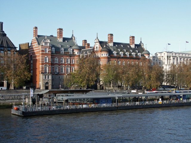
English: Old "New Scotland Yard", Westminster Viewers of old black-and-white crime dramas will recognise the red brick building on the right as the former HQ of the Metropolitan Police - before they moved nearer to the Home Office. It was, for example, in the opening credits of "Fabian of the Yard". On the extreme left is the edge of Portcullis House, new offices for MPs.
Español: Anterior sede de "Scotland Yard", en Westminster. Las personas de cierta edad interesadas en las historias de detectives y de misterios, y en especial los seguidores de la serie de televisión de la BBC titulada "Fabian of the Yard" (basada en los casos reales que tuvo a cargo el detective Robert Honey Fabian), probablemente reconocerán el edificio de ladrillo rojo a la derecha, y lo identificarán como la antigua sede de la Policía Metropolitana, antes de que la misma se mudara a su actual emplazamiento. En la parte izquierda de esta imagen, se aprecia un extremo del edificio llamado Portcullis House, donde se ubican actualmente las oficinas de los miembros del parlamento. |
| Թվական | |
| Աղբյուր | From geograph.org.uk |
| Հեղինակ | Anthony O'Neil |
| Հղում (required by the license) | Anthony O'Neil / Old "New Scotland Yard", Westminster / |
| Տեսախցիկի տեղագրություն | | Այս և ուրիշ պատկերներ իրենց տեղագրությամբ OpenStreetMap |
|---|
_heading:315.00&language=hy)
| Օբյեկտի տեղագրություն | | Այս և ուրիշ պատկերներ իրենց տեղագրությամբ OpenStreetMap |
|---|
_heading:315.00&language=hy)
Արտոնագրում

|
This image was taken from the Geograph project collection. See this photograph's page on the Geograph website for the photographer's contact details. The copyright on this image is owned by Anthony O'Neil and is licensed for reuse under the Creative Commons Attribution-ShareAlike 2.0 license.
|
This file is licensed under the Creative Commons Attribution-Share Alike 2.0 Generic license.
Հղում: Anthony O'Neil
- Դուք ազատ եք՝
- կիսվել ստեղծագործությամբ – պատճենել, տարածել և փոխանցել այս աշխատանքը։
- վերափոխել – ադապտացնել աշխատանքը
- Պահպանելով հետևյալ պայմանները'
- հղում – Դուք պետք է նշեք հեղինակի (իրավատիրոջ) հղումը:
- համանման տարածում – Եթե դուք ձևափոխում եք, փոխակերպում, կամ այս աշխատանքի հիման վրա ստեղծում եք նոր աշխատանք, ապա ձեր ստեղծածը կարող է տարածվել միայն նույն կամ համարժեք թույլատրագրով։
Նիշքի պատմություն
Մատնահարեք օրվան/ժամին՝ նիշքի այդ պահին տեսքը դիտելու համար։
| Օր/Ժամ | Մանրապատկեր | Օբյեկտի չափը | Մասնակից | Մեկնաբանություն | |
|---|---|---|---|---|---|
| ընթացիկ | 07:00, 4 Մարտի 2011 | | 640 × 480 (109 ԿԲ) | GeographBot | == {{int:filedesc}} == {{Information |description={{en|1=Old "New Scotland Yard", Westminster Viewers of old black-and-white crime dramas will recognise the red brick building on the right as the former HQ of the Metropolitan Police - before they moved n |
Նիշքի օգտագործում
Հետևյալ էջը հղվում է այս նիշքին՝
Նիշքի համընդհանուր օգտագործում
Հետևյալ այլ վիքիները օգտագործում են այս նիշքը՝
- Օգտագործումը dag.wikipedia.org կայքում
- Օգտագործումը el.wikipedia.org կայքում
- Օգտագործումը en.wikipedia.org կայքում
- Օգտագործումը fr.wikipedia.org կայքում
- Օգտագործումը ja.wikipedia.org կայքում
- Օգտագործումը ko.wikipedia.org կայքում
- Օգտագործումը ru.wikipedia.org կայքում
- Օգտագործումը sq.wikipedia.org կայքում
- Օգտագործումը uz.wikipedia.org կայքում
- Օգտագործումը www.wikidata.org կայքում