
Պատկեր:Marquesas Karte.png
Ավելի բարձր կետաչափով տարբերակ չկա։
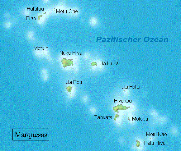
Marquesas_Karte.png (581 × 486 փիքսել, նիշքի չափը՝ 90 ԿԲ, MIME-տեսակը՝ image/png)

|
This map image could be re-created using vector graphics as an SVG file. This has several advantages; see Commons:Media for cleanup for more information. If an SVG form of this image is available, please upload it and afterwards replace this template with
{{vector version available|new image name}}.
It is recommended to name the SVG file “Marquesas Karte.svg”—then the template Vector version available (or Vva) does not need the new image name parameter. |
Ամփոփում
| Նկարագրում |
Deutsch: Karte der Marquesas, Französisch-Polynesien
English: Map of Marquesas Islands, French Polynesia |
| Թվական | |
| Աղբյուր | Բեռնողի սեփական աշխատանք, based on PD map from Demis |
| Հեղինակ | Demis |

|
Այս քարտեզը բարելավված է եղել գերմանական Kartenwerkstatt-ում: Դուք կարող եք նաև առաջարկել այլ քարտեզներ դրանց բարելավման համար:
|
Արտոնագրում
This image is in the public domain because it came from the site https://www.demis.nl/products/web-map-server/examples/ and was released by the copyright holder. Permission is granted to copy, distribute and/or modify this map since it is based on free of copyright images from: www.demis.nl. See also approval email on de.wp and its clarification.
|
| This work has been released into the public domain by its copyright holder, www.demis.nl. This applies worldwide. In some countries this may not be legally possible; if so: www.demis.nl grants anyone the right to use this work for any purpose, without any conditions, unless such conditions are required by law.
|
Original upload log
(All user names refer to de.wikipedia)
- 2009-04-20 15:43 NordNordWest 581×484 (90 KB) (ergänzt, beschnitten)
- 2005-02-18 14:28 Makemake 720×540 (107 KB) (Karte Marquesas, selbst gezeichnet unter Verwendung von http://www2.demis.nl/mapserver/mapper.asp, GNU-FDL)
- 2005-02-18 14:23 Makemake 720×540 (107 KB) Marquesas Iseln Karte, selbst gezeichnet unter verwendung vonhttp://www2.demis.nl/mapserver/mapper.asp, GNU-FDL )
- 2004-12-13 21:18 Makemake 540×720 (3 KB) (Karte Marquesas, selbst gezeichnet, GNU-FDL)
Նիշքի պատմություն
Մատնահարեք օրվան/ժամին՝ նիշքի այդ պահին տեսքը դիտելու համար։
| Օր/Ժամ | Մանրապատկեր | Օբյեկտի չափը | Մասնակից | Մեկնաբանություն | |
|---|---|---|---|---|---|
| ընթացիկ | 06:04, 21 Ապրիլի 2009 | | 581 × 486 (90 ԿԲ) | Telim tor | == {{int:filedesc}} == {{Information |Description= {{de|Karte der Marquesas, Französisch-Polynesien}} {{en|Map of Marquesas Islands, French Polynesia}} |Source={{own}}, based on PD map from [http://www2.demis.nl/mapserver/mapper.asp Demis] |Date={{Date|2 |
Նիշքի օգտագործում
Հետևյալ էջը հղվում է այս նիշքին՝
Նիշքի համընդհանուր օգտագործում
Հետևյալ այլ վիքիները օգտագործում են այս նիշքը՝
- Օգտագործումը af.wikipedia.org կայքում
- Օգտագործումը ast.wikipedia.org կայքում
- Օգտագործումը cv.wikipedia.org կայքում
- Օգտագործումը de.wikipedia.org կայքում
- Օգտագործումը eo.wikipedia.org կայքում
- Օգտագործումը es.wikipedia.org կայքում
- Օգտագործումը frr.wikipedia.org կայքում
- Օգտագործումը gl.wikipedia.org կայքում
- Օգտագործումը it.wikipedia.org կայքում
- Օգտագործումը nl.wikipedia.org կայքում
- Օգտագործումը pl.wikipedia.org կայքում
- Օգտագործումը ru.wikipedia.org կայքում
- Օգտագործումը simple.wikipedia.org կայքում
- Օգտագործումը tr.wikipedia.org կայքում