
Պատկեր:LanguageMap-Kikongo-Kituba.png

Նախադիտման չափ՝ 800 × 529 պիքսել։ Այլ թույլտվությաններ: 320 × 212 պիքսել | 640 × 423 պիքսել | 1024 × 677 պիքսել | 1420 × 939 պիքսել.
Սկզբնական նիշք (1420 × 939 փիքսել, նիշքի չափը՝ 89 ԿԲ, MIME-տեսակը՝ image/png)
Ամփոփում
| Նկարագրում |
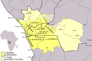
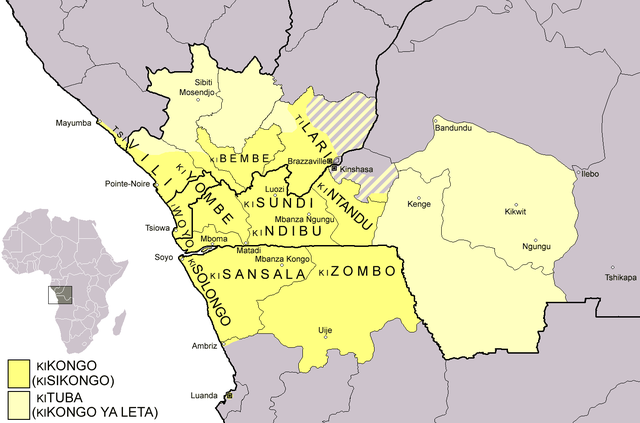
Dialect map of Kikongo. Dark yellow areas are inhabited mainly by first language speakers of the various dialects/languages of Kikongo. Names of some dialects/languages are written on the map. Pale yellow areas are inhabited by first and second language speakers of Kituba (a.k.a. Kikongo ya Leta), which is the lingua franca in the area. Kituba is understood by most speakers of Kikongo. Map drawn by Risto Kupsala. Details are based on the language maps of Ethnologue and several other sources. |
| Թվական | 2 Ապրիլ 2006 (original upload date) |
| Աղբյուր | No machine-readable source provided. Own work assumed (based on copyright claims). |
| Հեղինակ | No machine-readable author provided. Rasulo~commonswiki assumed (based on copyright claims). |
Արտոնագրում
| I, the copyright holder of this work, release this work into the public domain. This applies worldwide. In some countries this may not be legally possible; if so: I grant anyone the right to use this work for any purpose, without any conditions, unless such conditions are required by law. |
Նիշքի պատմություն
Մատնահարեք օրվան/ժամին՝ նիշքի այդ պահին տեսքը դիտելու համար։
| Օր/Ժամ | Մանրապատկեր | Օբյեկտի չափը | Մասնակից | Մեկնաբանություն | |
|---|---|---|---|---|---|
| ընթացիկ | 00:37, 25 փետրվարի 2021 | | 1420 × 939 (89 ԿԲ) | Somebody040404 | Reverted to version as of 10:10, 29 March 2018 (UTC) |
| 00:26, 25 փետրվարի 2021 |  | 1420 × 939 (82 ԿԲ) | Somebody040404 | ||
| 10:10, 29 Մարտի 2018 |  | 1420 × 939 (89 ԿԲ) | Maphobbyist | South Sudan border | |
| 21:24, 20 Դեկտեմբերի 2007 |  | 1420 × 939 (60 ԿԲ) | Rasulo~commonswiki | Dialect map of Kikongo. Dark yellow areas are inhabited mainly by native speakers of the various dialects/languages of Ki(si)kongo. Names of some dialects/languages are written on the map. Pale yellow areas are inhabited by first and second language speak | |
| 12:12, 22 Հուլիսի 2006 |  | 718 × 518 (26 ԿԲ) | Rasulo~commonswiki | ||
| 09:49, 2 Ապրիլի 2006 |  | 571 × 471 (20 ԿԲ) | Rasulo~commonswiki | Dialect map of Kikongo Dark green areas are inhabited mainly by first language speakers of the various dialects/languages of Kikongo. Names of some dialects/languages are written on the map. Light green areas are inhabited by first and second language spe |
Նիշքի օգտագործում
Հետևյալ 2 էջերը հղվում են այս նիշքին՝
Նիշքի համընդհանուր օգտագործում
Հետևյալ այլ վիքիները օգտագործում են այս նիշքը՝
- Օգտագործումը af.wikipedia.org կայքում
- Օգտագործումը ar.wikipedia.org կայքում
- Օգտագործումը ast.wikipedia.org կայքում
- Օգտագործումը az.wiktionary.org կայքում
- Օգտագործումը bn.wikipedia.org կայքում
- Օգտագործումը ca.wikipedia.org կայքում
- Օգտագործումը cs.wikipedia.org կայքում
- Օգտագործումը da.wikipedia.org կայքում
- Օգտագործումը de.wikipedia.org կայքում
- Օգտագործումը en.wikipedia.org կայքում
- Օգտագործումը eo.wikipedia.org կայքում
- Օգտագործումը es.wikipedia.org կայքում
- Օգտագործումը eu.wikipedia.org կայքում
- Օգտագործումը fi.wikipedia.org կայքում
- Օգտագործումը frr.wikipedia.org կայքում
- Օգտագործումը fr.wikipedia.org կայքում
Տեսնել այս նիշքի ավելի համընդհանուր օգտագործումը: