
Պատկեր:Karte 13 Alte Orte.png

Նախադիտման չափ՝ 800 × 529 պիքսել։ Այլ թույլտվությաններ: 320 × 211 պիքսել | 640 × 423 պիքսել | 1024 × 677 պիքսել | 1280 × 846 պիքսել | 2500 × 1652 պիքսել.
Սկզբնական նիշք (2500 × 1652 փիքսել, նիշքի չափը՝ 512 ԿԲ, MIME-տեսակը՝ image/png)
Ամփոփում
| Նկարագրում |
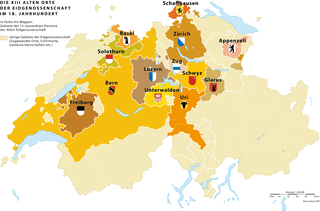
Deutsch: Die 13 «Alten Orte» (alte Kantone) der schweizerischen Eidgenossenschaft und ihr direkt beherrschtes Territorium im 18. Jahrhundert |
|
| Թվական | 3.5.2007 | |
| Աղբյուր | Բեռնողի սեփական աշխատանք | |
| Հեղինակ | Marco Zanoli (sidonius 19:14, 3 May 2007 (UTC)) | |
| Իրավունքներ (Նիշքի վերաօգտագործումը) |
|
|
| Այլ մեկնակերպներ |
|


|
This historical map image could be re-created using vector graphics as an SVG file. This has several advantages; see Commons:Media for cleanup for more information. If an SVG form of this image is available, please upload it and afterwards replace this template with
{{vector version available|new image name}}.
It is recommended to name the SVG file “Karte 13 Alte Orte.svg”—then the template Vector version available (or Vva) does not need the new image name parameter. |
Նիշքի պատմություն
Մատնահարեք օրվան/ժամին՝ նիշքի այդ պահին տեսքը դիտելու համար։
| Օր/Ժամ | Մանրապատկեր | Օբյեկտի չափը | Մասնակից | Մեկնաբանություն | |
|---|---|---|---|---|---|
| ընթացիկ | 08:59, 8 Մարտի 2022 | | 2500 × 1652 (512 ԿԲ) | Sidonius | minor adjustements, higher resolution |
| 04:51, 4 Հուլիսի 2010 |  | 1200 × 761 (236 ԿԲ) | DcoetzeeBot | Remove watermark, add author and license data to image metadata, decrease filesize with pngcrush | |
| 13:35, 3 Մայիսի 2007 |  | 1200 × 761 (235 ԿԲ) | Sidonius | {{Information |Description={{de|Die 13 «Alten Orte» (alte Kantone) der schweizerischen Eidgenossenschaft und ihr direkt beherrschtes Territorium im 18. Jahrhundert}} |Source=own work |Date=3.5.2007 |Author= |Permission={{A |
Նիշքի օգտագործում
Հետևյալ էջը հղվում է այս նիշքին՝
Նիշքի համընդհանուր օգտագործում
Հետևյալ այլ վիքիները օգտագործում են այս նիշքը՝
- Օգտագործումը als.wikipedia.org կայքում
- Օգտագործումը bn.wikipedia.org կայքում
- Օգտագործումը cs.wikipedia.org կայքում
- Օգտագործումը de.wikipedia.org կայքում
- Օգտագործումը en.wikipedia.org կայքում
- Օգտագործումը eo.wikipedia.org կայքում
- Օգտագործումը et.wikipedia.org կայքում
- Օգտագործումը fi.wikipedia.org կայքում
- Օգտագործումը fr.wikipedia.org կայքում
- Օգտագործումը gl.wikipedia.org կայքում
- Օգտագործումը he.wikipedia.org կայքում
- Օգտագործումը ilo.wikipedia.org կայքում
- Օգտագործումը it.wikipedia.org կայքում
- Օգտագործումը ka.wikipedia.org կայքում
- Օգտագործումը ko.wikipedia.org կայքում
- Օգտագործումը nl.wikipedia.org կայքում
- Օգտագործումը sl.wikipedia.org կայքում
- Օգտագործումը sv.wikipedia.org կայքում
- Օգտագործումը uk.wikipedia.org կայքում
- Օգտագործումը zh.wikipedia.org կայքում