Պատկեր:Italy 1000 AD.svg
Page contents not supported in other languages.
Վիքիպեդիայից՝ ազատ հանրագիտարանից

Սկզբնական նիշք(SVG-նիշք, անվանապես 565 × 811 փիքսել, նիշքի չափը՝ 861 ԿԲ)

Այս նիշքը տեղադրված է Վիքիպահեստում է և այն կարող է օգտագործվել այլ նախագծերի կողմից։ Վիքիպահեստում նիշքի մասին տեղեկությունների հիմնական մասը ներկայացված է ստորև։

Ամփոփում

Նկարագրում
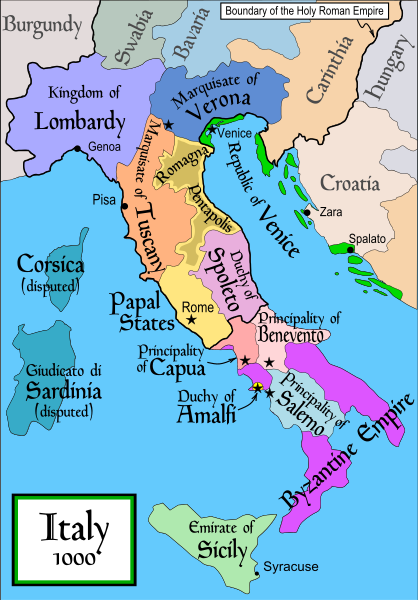
English: Political map of Italy in 1000 AD (CE). Created by MapMaster. Part of a series of maps on the history of Italy:
Թվական 17 Նոյեմբեր 2006 (original upload date)
Աղբյուր No machine-readable source provided. Own work assumed (based on copyright claims).
Հեղինակ No machine-readable author provided. MapMaster assumed (based on copyright claims).
Այլ մեկնակերպներ

[խմբագրել]


 SVG:


 PNG:


Translate this file

Այս SVG ֆայլ օգտագործում է զետեղված տեքստ, որը կարելի է հեշտ թարգմանել ձեր լեզվի վրա using [toolforge:svgtranslate/File:Italy_1000_AD.svglink this automated tool]: Իմացեք ավելին: You can also download it and translate it manually using a text editor.

References

In addition, a number of other sources were consulted in an effort to determine the following matters:

  • The extent of Venetian control over the cities of Dalmatia such as Zara and Spalato. Although the Venetians had been pushed off the mainland earlier, in the period around the year 1000, the Venetians made an effort to recover these cities.
  • The extent of Saracen control over Corsica and Sardinia. Information is sparse. The apparent situation is that the Muslims had several bases on the coasts of these islands, but did not control the countryside (such as they did in Sicily).
  • Whether or not the principalities of Capua and Benevento were separate states in the year 1000. Based on lists of their rulers (various Pandulfs and Landulfs), the answer seems to be "yes".
  • Who controlled the Balkans on the southeastern border of the Kingdom of Croatia. Candidates include Bulgaria, the Byzantine Empire, Croatia, and Serbia.

As noted, there is significant disagreement among sources on these questions.

This map was commissioned by Attilios, and there is also a discussion to be found on MapMaster's English talk page.

Արտոնագրում

Ես, սույն աշխատանքի հեղինակային իրավունքների տերը, այսուհետ այն հրատարակում եմ հետևյալ արտոնագրի ներքո։
GNU head Այս վավերագրման պատճենահանման, տարածման և/կամ ձևափոխման թույլտվություն կամ լիցենզիայի GNU FDL պայմաններով 1.2 մեկնակերպի կամ ավելի ուշ, հրատարակված Ազատ ծրագրային ապահովության հիմնադրամում, առանց անփոփոխելի հատվածների, առանց բնագիրների, որոնք տեղադրված են առաջին և վերջին շապիկներում: Լիցենզիայի պատճենը գտնվում է GNU Free Documentation License հատվածում:
w:en:Creative Commons
հղում համանման տարածում
Այս նիշքը հասանելի է Creative Commons Attribution-Share Alike 3.0 Unported արտոնագրի ներքո:
Դուք ազատ եք՝
  • կիսվել ստեղծագործությամբ – պատճենել, տարածել և փոխանցել այս աշխատանքը։
  • վերափոխել – ադապտացնել աշխատանքը
Պահպանելով հետևյալ պայմանները'
  • հղում – Դուք պետք է նշեք հեղինակի (իրավատիրոջ) հղումը:
  • համանման տարածում – Եթե դուք ձևափոխում եք, փոխակերպում, կամ այս աշխատանքի հիման վրա ստեղծում եք նոր աշխատանք, ապա ձեր ստեղծածը կարող է տարածվել միայն նույն կամ համարժեք թույլատրագրով։
Այս արտոնգրության հատկանիշը ավելացված է տվյալ նիշքին որպես GFDL արտոնագրի բարեփոխում:

derivative works

Derivative works of this file:  Italya MS 1000.svg

Captions

Add a one-line explanation of what this file represents

Items portrayed in this file

պատկերված

17 Նոյեմբերի 2006

Նիշքի պատմություն

Մատնահարեք օրվան/ժամին՝ նիշքի այդ պահին տեսքը դիտելու համար։

Օր/ԺամՄանրապատկերՕբյեկտի չափըՄասնակիցՄեկնաբանություն
ընթացիկ19:50, 17 Ապրիլի 200719:50, 17 Ապրիլի 2007 տարբերակի մանրապատկերը565 × 811 (861 ԿԲ)MapMasterSome further changes
05:10, 19 փետրվարի 200705:10, 19 փետրվարի 2007 տարբերակի մանրապատկերը565 × 811 (824 ԿԲ)MapMasterchanges to ensure consistency with my other Italy maps
05:39, 25 Նոյեմբերի 200605:39, 25 Նոյեմբերի 2006 տարբերակի մանրապատկերը565 × 811 (823 ԿԲ)MapMasterImproved map.
14:44, 18 Նոյեմբերի 200614:44, 18 Նոյեմբերի 2006 տարբերակի մանրապատկերը565 × 811 (827 ԿԲ)MapMasterImproved (I hope) version based on recommendations from Attilios.
21:50, 17 Նոյեմբերի 200621:50, 17 Նոյեմբերի 2006 տարբերակի մանրապատկերը565 × 811 (768 ԿԲ)MapMasterPolitical map of Italy in 1000 AD (CE).

Հետևյալ էջը հղվում է այս նիշքին՝

Նիշքի համընդհանուր օգտագործում

Հետևյալ այլ վիքիները օգտագործում են այս նիշքը՝

Տեսնել այս նիշքի ավելի համընդհանուր օգտագործումը: