
Պատկեր:IslamicConquestsIroon.png
Նախադիտման չափ՝ 675 × 599 պիքսել։ Այլ թույլտվությաններ: 270 × 240 պիքսել | 541 × 480 պիքսել | 1006 × 893 պիքսել.
Սկզբնական նիշք (1006 × 893 փիքսել, նիշքի չափը՝ 105 ԿԲ, MIME-տեսակը՝ image/png)

|
This historical map image could be re-created using vector graphics as an SVG file. This has several advantages; see Commons:Media for cleanup for more information. If an SVG form of this image is available, please upload it and afterwards replace this template with
{{vector version available|new image name}}.
It is recommended to name the SVG file “IslamicConquestsIroon.svg”—then the template Vector version available (or Vva) does not need the new image name parameter. |
| Նկարագրում |
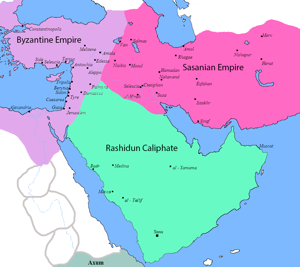
English: Map of the Sassanid, Byzantine and Muslim borders. |
| Աղբյուր | File:Pre_Islamic_Arabia.PNG |
| Հեղինակ | Javierfv1212 and edited by HistoryofIran. |
| Այլ մեկնակերպներ |
[]
|


This file is in the public domain because File:Pre_Islamic_Arabia.PNG
|
Նիշքի պատմություն
Մատնահարեք օրվան/ժամին՝ նիշքի այդ պահին տեսքը դիտելու համար։
| Օր/Ժամ | Մանրապատկեր | Օբյեկտի չափը | Մասնակից | Մեկնաբանություն | |
|---|---|---|---|---|---|
| ընթացիկ | 10:13, 18 Սեպտեմբերի 2019 | | 1006 × 893 (105 ԿԲ) | HistoryofIran | rv, thats not how it works |
| 04:51, 18 Սեպտեմբերի 2019 |  | 1006 × 893 (103 ԿԲ) | Сахалин21 | Under Hormizd IV, Persia won the Perso-Turkic War and conquered Samarqand and the Transoxiania. | |
| 04:50, 18 Սեպտեմբերի 2019 |  | 1006 × 893 (105 ԿԲ) | Сахалин21 | Reverted to version as of 01:15, 3 August 2019 (UTC) | |
| 04:45, 18 Սեպտեմբերի 2019 |  | 1006 × 893 (103 ԿԲ) | Сахалин21 | Reverted to version as of 19:13, 14 November 2017 (UTC) | |
| 01:15, 3 Օգոստոսի 2019 |  | 1006 × 893 (105 ԿԲ) | HistoryofIran | rv, no, they weren't at all | |
| 18:38, 1 Օգոստոսի 2019 |  | 1006 × 893 (105 ԿԲ) | Mehrdad 12 | The eastern borders were conquered during the reign of Queen Purandokht. | |
| 18:34, 1 Օգոստոսի 2019 |  | 1006 × 893 (106 ԿԲ) | Mehrdad 12 | I corrected the eastern borders. The Great Khorasan and Khwarizmi Desert were considered imperial. | |
| 02:51, 12 փետրվարի 2019 |  | 1006 × 893 (105 ԿԲ) | HistoryofIran | Made the map somewhat more accurate, probably more to come. | |
| 19:13, 14 Նոյեմբերի 2017 |  | 1006 × 893 (103 ԿԲ) | HistoryofIran | rv, the Sasanian Empire didnt control that much | |
| 11:02, 12 Նոյեմբերի 2017 |  | 1006 × 893 (128 ԿԲ) | Mehrdad 12 | {{NAMESPACE}}{{PAGENAME}}[[]][[:File:]]]] |
Նիշքի օգտագործում
Հետևյալ 4 էջերը հղվում են այս նիշքին՝
Նիշքի համընդհանուր օգտագործում
Հետևյալ այլ վիքիները օգտագործում են այս նիշքը՝
- Օգտագործումը bg.wikipedia.org կայքում
- Օգտագործումը bn.wikipedia.org կայքում
- Օգտագործումը bn.wikiquote.org կայքում
- Օգտագործումը bs.wikipedia.org կայքում
- Օգտագործումը cs.wikipedia.org կայքում
- Օգտագործումը da.wikipedia.org կայքում
- Օգտագործումը de.wikipedia.org կայքում
- Օգտագործումը diq.wikipedia.org կայքում
- Օգտագործումը en.wikipedia.org կայքում
- Օգտագործումը fa.wikipedia.org կայքում
- Օգտագործումը fa.wikibooks.org կայքում
- Օգտագործումը fi.wikipedia.org կայքում
- Օգտագործումը fr.wikipedia.org կայքում
- Օգտագործումը he.wikipedia.org կայքում
- Օգտագործումը hr.wikipedia.org կայքում
- Օգտագործումը hyw.wikipedia.org կայքում
- Օգտագործումը ka.wikipedia.org կայքում
- Օգտագործումը ko.wikipedia.org կայքում
- Օգտագործումը ru.wikipedia.org կայքում
- Օգտագործումը sr.wikipedia.org կայքում
- Օգտագործումը sv.wikipedia.org կայքում
- Օգտագործումը ta.wikipedia.org կայքում
- Օգտագործումը th.wikipedia.org կայքում
- Օգտագործումը tr.wikipedia.org կայքում
- Օգտագործումը uk.wikipedia.org կայքում
- Օգտագործումը zh.wikipedia.org կայքում