
Պատկեր:Gauleptolemee1578.jpg

Նախադիտման չափ՝ 568 × 600 պիքսել։ Այլ թույլտվությաններ: 227 × 240 պիքսել | 454 × 480 պիքսել | 727 × 768 պիքսել | 1227 × 1296 պիքսել.
Սկզբնական նիշք (1227 × 1296 փիքսել, նիշքի չափը՝ 270 ԿԲ, MIME-տեսակը՝ image/jpeg)
Ամփոփում
| Նկարագրում |
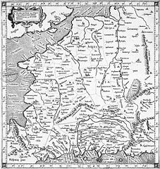
Français : Carte datant de 1578 représentant la Gaule au temps de Ptolémée |
| Թվական | |
| Աղբյուր | [1] |
| Հեղինակ | Ptolemy |
![[1]](http://www.orpaillage.fr/histoire/gauleptolemee1578.jpg)
Արտոնագրում
|
This work is in the public domain in its country of origin and other countries and areas where the copyright term is the author's life plus 100 years or fewer. | |
| This file has been identified as being free of known restrictions under copyright law, including all related and neighboring rights. | |
Նիշքի պատմություն
Մատնահարեք օրվան/ժամին՝ նիշքի այդ պահին տեսքը դիտելու համար։
| Օր/Ժամ | Մանրապատկեր | Օբյեկտի չափը | Մասնակից | Մեկնաբանություն | |
|---|---|---|---|---|---|
| ընթացիկ | 20:10, 5 Ապրիլի 2008 | | 1227 × 1296 (270 ԿԲ) | Thesupermat | {{Information |Description=Carte datant de 1578 représentant la Gaule au temps de Ptolémée |Source=http://www.orpaillage.fr/histoire/gauleptolemee1578.jpg |Date=1578 |Author=unknow |Permission= |other_versions= }} Category:Maps of Roman Gaul |
Նիշքի օգտագործում
Հետևյալ էջը հղվում է այս նիշքին՝
Նիշքի համընդհանուր օգտագործում
Հետևյալ այլ վիքիները օգտագործում են այս նիշքը՝
- Օգտագործումը da.wikipedia.org կայքում
- Օգտագործումը en.wikipedia.org կայքում
- Օգտագործումը eo.wikipedia.org կայքում
- Օգտագործումը fr.wikipedia.org կայքում
- Օգտագործումը ru.wikipedia.org կայքում