
Պատկեր:Florida topographic map-en.svg

Սկզբնական նիշք (SVG-նիշք, անվանապես 2890 × 2810 փիքսել, նիշքի չափը՝ 2,51 ՄԲ)
|

Ամփոփում
| Description |
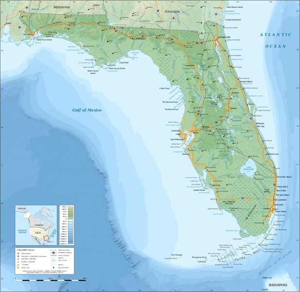
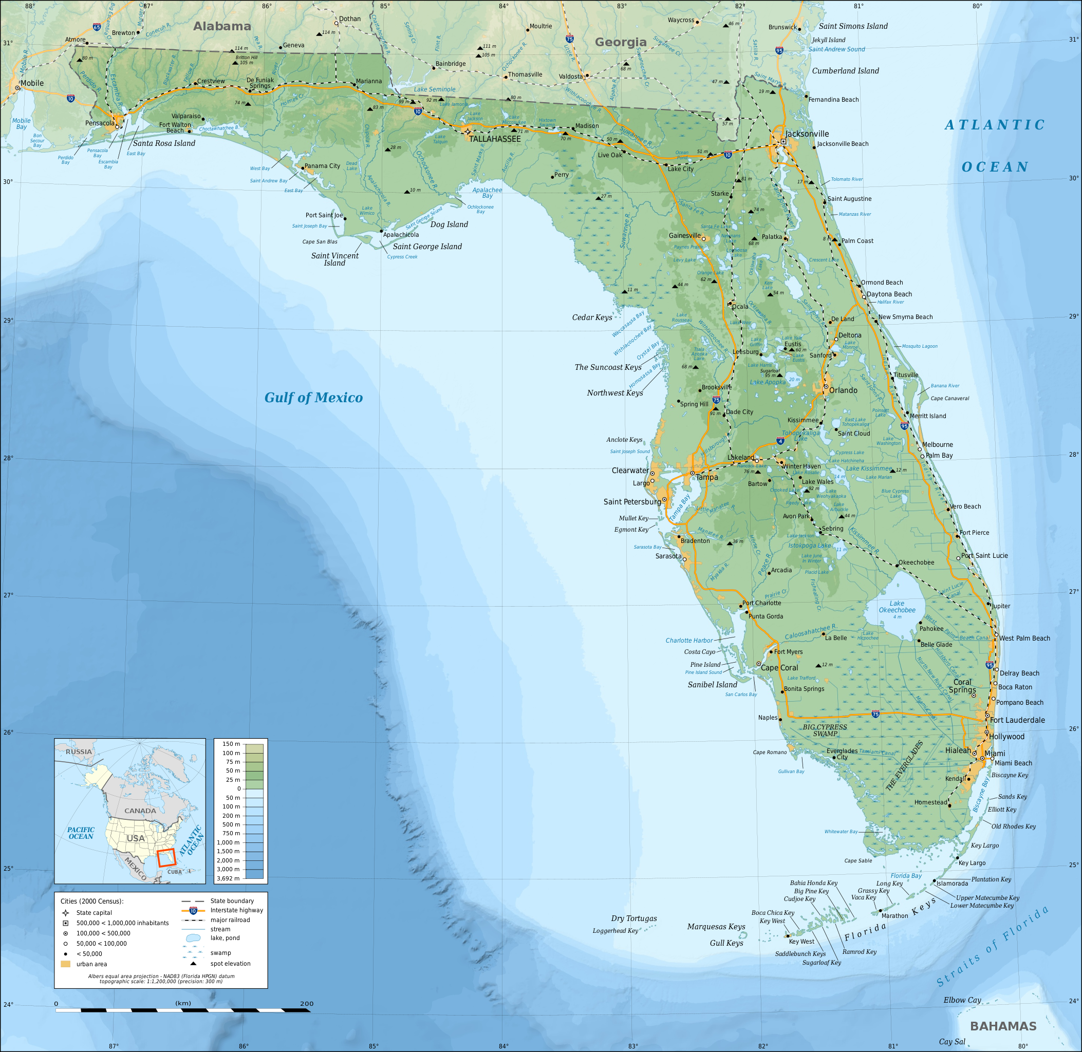
English: Topographic map of the State of Florida, USA (2000 Census).
Note: the background map is a raster image embedded in the SVG file. Español: Mapa topográfico del estado de Florida, Estados Unidos (censo del 2000).
Nota: el fondo del mapa es una imagen incrustada en el archivo SVG. Français : Carte topographique de l'état de Floride, États-Unis (recensement 2000). Note : le fond de carte est une image bitmap embarquée dans le fichier SVG. Albers equal area projection; NAD83 (Florida HPGN) datum |
||
| Թվական | |||
| Աղբյուր |
Բեռնողի սեփական աշխատանք
|
||
| Ստեղծել է | |||
| Իրավունքներ (Նիշքի վերաօգտագործումը) |
|
||
| Georeferencing | If inappropriate please set warp_status = skip to hide. | ||
| Այլ մեկնակերպներ |
[]
|


|
Այս SVG ֆայլ օգտագործում է զետեղված տեքստ, որը կարելի է հեշտ թարգմանել ձեր լեզվի վրա using [toolforge:svgtranslate/File:Florida_topographic_map-en.svglink this automated tool]: Իմացեք ավելին: You can also download it and translate it manually using a text editor. |
Արտոնագրում

|
Այս վավերագրման պատճենահանման, տարածման և/կամ ձևափոխման թույլտվություն կամ լիցենզիայի GNU FDL պայմաններով 1.2 մեկնակերպի կամ ավելի ուշ, հրատարակված Ազատ ծրագրային ապահովության հիմնադրամում, առանց անփոփոխելի հատվածների, առանց բնագիրների, որոնք տեղադրված են առաջին և վերջին շապիկներում: Լիցենզիայի պատճենը գտնվում է GNU Free Documentation License հատվածում: |
- Դուք ազատ եք՝
- կիսվել ստեղծագործությամբ – պատճենել, տարածել և փոխանցել այս աշխատանքը։
- վերափոխել – ադապտացնել աշխատանքը
- Պահպանելով հետևյալ պայմանները'
- հղում – Դուք պետք է նշեք հեղինակի (իրավատիրոջ) հղումը:
- համանման տարածում – Եթե դուք ձևափոխում եք, փոխակերպում, կամ այս աշխատանքի հիման վրա ստեղծում եք նոր աշխատանք, ապա ձեր ստեղծածը կարող է տարածվել միայն նույն կամ համարժեք թույլատրագրով։
Նիշքի պատմություն
Մատնահարեք օրվան/ժամին՝ նիշքի այդ պահին տեսքը դիտելու համար։
| Օր/Ժամ | Մանրապատկեր | Օբյեկտի չափը | Մասնակից | Մեկնաբանություն | |
|---|---|---|---|---|---|
| ընթացիկ | 15:26, 16 Դեկտեմբերի 2008 | | 2890 × 2810 (2,51 ՄԲ) | Sting | Added summits names |
| 01:34, 15 Դեկտեմբերի 2008 |  | 2890 × 2810 (2,51 ՄԲ) | Sting | == Summary == {{Information |Description={{en|Topographic map of the State of Florida, USA (2000 Census).<br/>''Note: the background map is a raster image embedded in the SVG file.''} |
Նիշքի օգտագործում
Հետևյալ էջը հղվում է այս նիշքին՝
Նիշքի համընդհանուր օգտագործում
Հետևյալ այլ վիքիները օգտագործում են այս նիշքը՝
- Օգտագործումը af.wikipedia.org կայքում
- Օգտագործումը ang.wikipedia.org կայքում
- Օգտագործումը arz.wikipedia.org կայքում
- Օգտագործումը az.wikipedia.org կայքում
- Օգտագործումը ban.wikipedia.org կայքում
- Օգտագործումը be.wikipedia.org կայքում
- Օգտագործումը bn.wikipedia.org կայքում
- Օգտագործումը ca.wikipedia.org կայքում
- Օգտագործումը de.wikipedia.org կայքում
- Օգտագործումը el.wikipedia.org կայքում
- Օգտագործումը en.wikipedia.org կայքում
- Portal:Geography
- Portal:Geography/Featured picture
- Portal:Florida
- User talk:Sting
- Wikipedia:Graphics Lab/Resources/Tutorials
- Wikipedia:Featured pictures/Diagrams, drawings, and maps/Maps
- Geography of Florida
- Florida
- Wikipedia:WikiProject United States/Recognized content
- Wikipedia:Featured pictures thumbs/26
- Wikipedia:WikiProject United States/Quality content
- User talk:Jujutacular/Archive 9
- Wikipedia:Featured picture candidates/December-2010
- Wikipedia:Featured picture candidates/Topographic map of Florida
- Talk:Geography of Florida
- Template:POTD/2013-03-03
- Portal:Geography/Featured picture/4
- Wikipedia:Picture of the day/March 2013
- User talk:Jujutacular/Archive 15
- Wikipedia:Main Page history/2013 March 3
- User:Abyssal/bla
- Portal:Geography/Selected picture
- Wikipedia:WikiProject United States/Featured pictures
- Օգտագործումը es.wikipedia.org կայքում
- Օգտագործումը fr.wikipedia.org կայքում
- Օգտագործումը fy.wikipedia.org կայքում
- Օգտագործումը ga.wikipedia.org կայքում
- Օգտագործումը gl.wikipedia.org կայքում
- Օգտագործումը gn.wikipedia.org կայքում
- Օգտագործումը hu.wikipedia.org կայքում
- Օգտագործումը hyw.wikipedia.org կայքում
- Օգտագործումը io.wikipedia.org կայքում
- Օգտագործումը ka.wikipedia.org կայքում
Տեսնել այս նիշքի ավելի համընդհանուր օգտագործումը: