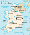
Պատկեր:Ei-map rus.svg

Page contents not supported in other languages.
Վիքիպեդիայից՝ ազատ հանրագիտարանից

Սկզբնական նիշք(SVG-նիշք, անվանապես 652 × 756 փիքսել, նիշքի չափը՝ 105 ԿԲ)

Այս նիշքը տեղադրված է Վիքիպահեստում է և այն կարող է օգտագործվել այլ նախագծերի կողմից։ Վիքիպահեստում նիշքի մասին տեղեկությունների հիմնական մասը ներկայացված է ստորև։

Նկարագրում Vector version of CIA WorldBook map of the Republic of Ireland. Mercator projection. Vector information is from the CIA World DataBank II, and hence in the public domain.
Թվական (UTC)
Աղբյուր
Հեղինակ
Այլ մեկնակերպներ

[խմբագրել]


Սա խմբագրված պատկեր է, որը համեմատ բնօրինակին ենթարկվել է թվային մշակման։ Փոփոխությունները՝ russification: Սկզբնական պատկերը գտնվում է այստեղ՝ Ei-map.svg։ Խմբագրել է Nekto մասնակիցը։

Ես, սույն աշխատանքի հեղինակային իրավունքների տերը, այսուհետ այն հրատարակում եմ հետևյալ արտոնագրի ներքո։
Public domain I, the copyright holder of this work, release this work into the public domain. This applies worldwide.
In some countries this may not be legally possible; if so:
I grant anyone the right to use this work for any purpose, without any conditions, unless such conditions are required by law.

Original upload log

This image is a derivative work of the following images:

  • File:Ei-map.svg licensed with PD-self
    • 2006-07-24T22:16:07Z Wereon 652x756 (101477 Bytes) Vector version of CIA WorldBook map of the Republic of Ireland. Mercator projection. Vector information is from the CIA World DataBank II, and hence in the public domain.

Uploaded with derivativeFX

Captions

Add a one-line explanation of what this file represents

Items portrayed in this file

պատկերված

22 Մայիսի 2009

Նիշքի պատմություն

Մատնահարեք օրվան/ժամին՝ նիշքի այդ պահին տեսքը դիտելու համար։

Օր/ԺամՄանրապատկերՕբյեկտի չափըՄասնակիցՄեկնաբանություն
ընթացիկ17:03, 22 Մայիսի 200917:03, 22 Մայիսի 2009 տարբերակի մանրապատկերը652 × 756 (105 ԿԲ)Nektocorrection
16:55, 22 Մայիսի 200916:55, 22 Մայիսի 2009 տարբերակի մանրապատկերը652 × 756 (105 ԿԲ)Nekto{{Information |Description=Vector version of CIA WorldBook map of the Republic of Ireland. Mercator projection. Vector information is from the CIA World DataBank II, and hence in the public domain. |Source=*File:Ei-map.svg |Date=2009-05-22 17:54 (U

Հետևյալ էջը հղվում է այս նիշքին՝

Նիշքի համընդհանուր օգտագործում

Հետևյալ այլ վիքիները օգտագործում են այս նիշքը՝