
Պատկեր:DjoudjNASA.jpg
Ավելի բարձր կետաչափով տարբերակ չկա։
DjoudjNASA.jpg (560 × 305 փիքսել, նիշքի չափը՝ 79 ԿԲ, MIME-տեսակը՝ image/jpeg)
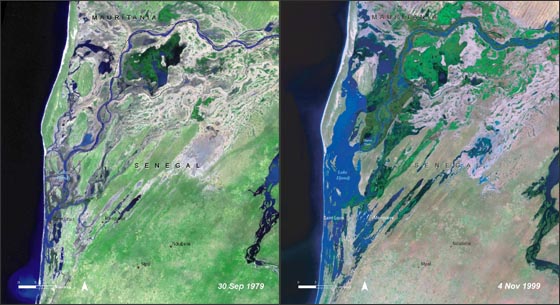
| Նկարագրում | Lake Djoudj during the Sept. 1979 drought (left) and during the Nov. 1999 flood (right). http://landsat.gsfc.nasa.gov/images/archive/f0011.html In August 2006, the United Nations Environment Programme (UNEP), released an atlas entitled: "Africa's Lakes: Atlas of Our Changing Environment." The atlas relies heavily on Landsat imagery from the past 34 years to show changes in lakes around the African continent. Above, are two Landsat images of the Djoudj Sanctuary in Senegal that are featured in the atlas. The atlas tell us: "Situated in the Senegal river delta, the Djoudj Sanctuary is a wetland of 16 000 ha, comprising a large lake, referred to as Lake Djoudj in this publication, surrounded by streams, ponds and backwaters. These two images show the Djoudj Sanctuary before and after the construction of the Diama Dam." "The image from September 1979 shows the impact of drought on the Djoudj Sanctuary, while the image from November 1999 shows rejuvenation of the sanctuary wetlands due to the significant floods of that year. The two images vividly depict the impact of climate variability on the Djoudj Sanctuary—and demonstrate the broader need for close monitoring of the impacts of climate variability and climate change on lake environments." |
| Թվական | August 2006 September 1979 November 1999 (5 Հոկտեմբեր 2006 (according to Exif data)) |
| Աղբյուր | NASA [1] |
| Հեղինակ | անհայտ |
| Այս նիշքը հանրության սեփականության է պատկանում, քանզի այն ստեղծվել է ՆԱՍԱ-ն։ ՆԱՍԱ-ի հեղինակային իրավունքների մասին քաղաքականությունը նշում է, որ «ՆԱՍԱ-ի նյութերը հեղինակային իրավունքներով պաշտպանված չեն, միթե այդպես նշված լինի»։ (Տե՛ս Template:PD-USGov, ՆԱՍԱ-ի հեղինակային իրավունքների քաղաքականության մասին էջը կամ ՋեյՓիԷլի պատկերների օգտագործման մասին քաղաքականությունը)։ | ||
 |
Զգուշացումներ՝:
|
Նիշքի պատմություն
Մատնահարեք օրվան/ժամին՝ նիշքի այդ պահին տեսքը դիտելու համար։
| Օր/Ժամ | Մանրապատկեր | Օբյեկտի չափը | Մասնակից | Մեկնաբանություն | |
|---|---|---|---|---|---|
| ընթացիկ | 20:03, 16 Օգոստոսի 2007 | | 560 × 305 (79 ԿԲ) | Ji-Elle | Lake Djoudj during the Sept. 1979 drought (left) and during the Nov. 1999 flood (right). http://landsat.gsfc.nasa.gov/images/archive/f0011.html In August 2006, the United Nations Environment Programme (UNEP), released an atlas entitled: "Africa's Lakes: |
Նիշքի օգտագործում
Հետևյալ էջը հղվում է այս նիշքին՝
Նիշքի համընդհանուր օգտագործում
Հետևյալ այլ վիքիները օգտագործում են այս նիշքը՝
- Օգտագործումը ar.wikipedia.org կայքում
- Օգտագործումը az.wikipedia.org կայքում
- Օգտագործումը ca.wikipedia.org կայքում
- Օգտագործումը en.wikipedia.org կայքում
- Օգտագործումը en.wikinews.org կայքում
- Օգտագործումը fr.wikipedia.org կայքում
- Օգտագործումը mt.wikipedia.org կայքում
- Օգտագործումը ru.wikipedia.org կայքում
- Օգտագործումը ru.wikinews.org կայքում
- Օգտագործումը www.wikidata.org կայքում