
Պատկեր:Deepwater Horizon oil spill - May 24, 2010.jpg

Սկզբնական նիշք (2118 × 1628 փիքսել, նիշքի չափը՝ 369 ԿԲ, MIME-տեսակը՝ image/jpeg)
Ամփոփում
| Նկարագրում |
English: Description from NASA (source):
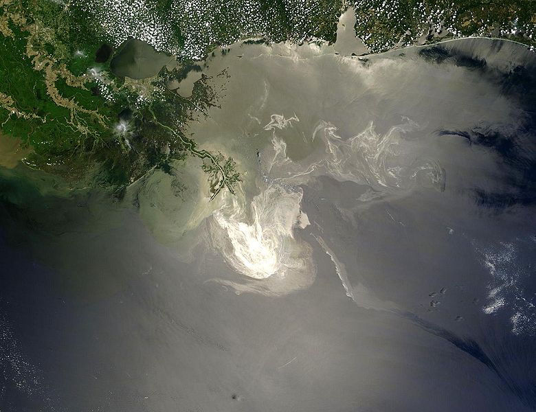
"NASA's Terra Satellites Sees Spill on May 24
Français : Traduction partielle de la description par la NASA(source): La marée noire causée par l'incendie de la plateforme pétrolière Deepwater Horizon vue par le satellite Terra, de la NASA, le 24 mai 2010.
Cette image a été acquise par le Moderate-Resolution Imaging Spectroradiometer (MODIS, pour Spectroradiomètre d'imagerie à résolution moyenne), embarqué sur le satellite Terra. Le pétrole lisse la surface de l'océan, ce qui la rend plus claire là où elle réfléchit le soleil (par exemple, au centre de la photo) et plus sombre ailleurs (par exemple en bas à droite). Le delta du Mississippi est visible en haut, entouré d'eaux saumâtres et boueuses qui apparaissent en brun, rayé de rubans argentés de pétrole. |
| Թվական | |
| Աղբյուր | Original image, here cropped on left and at top |
| Հեղինակ | NASA/GSFC, MODIS Rapid Response |
| Այլ մեկնակերպներ |
|

|

Արտոնագրում
| Այս նիշքը հանրության սեփականության է պատկանում, քանզի այն ստեղծվել է ՆԱՍԱ-ն։ ՆԱՍԱ-ի հեղինակային իրավունքների մասին քաղաքականությունը նշում է, որ «ՆԱՍԱ-ի նյութերը հեղինակային իրավունքներով պաշտպանված չեն, միթե այդպես նշված լինի»։ (Տե՛ս Template:PD-USGov, ՆԱՍԱ-ի հեղինակային իրավունքների քաղաքականության մասին էջը կամ ՋեյՓիԷլի պատկերների օգտագործման մասին քաղաքականությունը)։ | ||
 |
Զգուշացումներ՝:
|
Նիշքի պատմություն
Մատնահարեք օրվան/ժամին՝ նիշքի այդ պահին տեսքը դիտելու համար։
| Օր/Ժամ | Մանրապատկեր | Օբյեկտի չափը | Մասնակից | Մեկնաբանություն | |
|---|---|---|---|---|---|
| ընթացիկ | 05:26, 26 Մայիսի 2010 | | 2118 × 1628 (369 ԿԲ) | APK | == Summary == {{Information |Description={{en|"Sunlight illuminated the lingering oil slick off the Mississippi Delta on May 24, 2010. The Moderate Resolution Imaging Spectroradiometer (MODIS) on NASA’s Terra satellit |
Նիշքի օգտագործում
Հետևյալ էջը հղվում է այս նիշքին՝
Նիշքի համընդհանուր օգտագործում
Հետևյալ այլ վիքիները օգտագործում են այս նիշքը՝
- Օգտագործումը af.wikipedia.org կայքում
- Օգտագործումը be.wikipedia.org կայքում
- Օգտագործումը ca.wikipedia.org կայքում
- Օգտագործումը cs.wikipedia.org կայքում
- Օգտագործումը da.wikipedia.org կայքում
- Օգտագործումը de.wikipedia.org կայքում
- Օգտագործումը el.wikipedia.org կայքում
- Օգտագործումը en.wikipedia.org կայքում
- Marine conservation
- Portal:Marine life
- Wikipedia:Featured pictures/Space/Looking back
- Wikipedia:Featured picture candidates/delist/2010
- Wikipedia:Featured pictures thumbs/23
- Wikipedia:Featured picture candidates/June-2010
- Wikipedia:ITN archives/2010/May
- Talk:Deepwater Horizon oil spill/Archive 4
- Wikipedia:Featured picture candidates/Deepwater Horizon oil spill - May 24, 2010.jpg
- Wikipedia:Wikipedia Signpost/2010-06-28/Features and admins
- User talk:APK/Archive 22
- Wikipedia:Featured picture candidates/delist/Deepwater oil spill 5-24-10
- Talk:Deepwater Horizon oil spill/Archive 10
- Wikipedia:Picture of the day/April 2012
- Template:POTD/2012-04-20
- Wikipedia:Main Page history/2012 April 20
- User talk:APK/Archive 25
- Research and Development Institute of Ecology and the Sustainable Use of Natural Resources
- Wikipedia:Wikipedia Signpost/Single/2010-06-28
- Flash-gas (petroleum)
- Օգտագործումը en.wikinews.org կայքում
- Օգտագործումը et.wikipedia.org կայքում
- Օգտագործումը fa.wikipedia.org կայքում
- Օգտագործումը fr.wikibooks.org կայքում
- Օգտագործումը he.wikipedia.org կայքում
- Օգտագործումը hr.wikipedia.org կայքում
- Օգտագործումը hu.wikinews.org կայքում
- Օգտագործումը lv.wikipedia.org կայքում
- Օգտագործումը ms.wikipedia.org կայքում
- Օգտագործումը nl.wikipedia.org կայքում
Տեսնել այս նիշքի ավելի համընդհանուր օգտագործումը: