
Պատկեր:Canadawineregions.png

Նախադիտման չափ՝ 685 × 599 պիքսել։ Այլ թույլտվությաններ: 274 × 240 պիքսել | 549 × 480 պիքսել | 878 × 768 պիքսել | 1171 × 1024 պիքսել | 1388 × 1214 պիքսել.
Սկզբնական նիշք (1388 × 1214 փիքսել, նիշքի չափը՝ 67 ԿԲ, MIME-տեսակը՝ image/png)
Ամփոփում
| Նկարագրում |
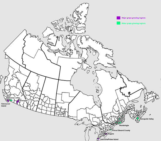
English: Map of grape growing regions in Canada. Own work based on Public Domain Census Subdivision map by Earl Andrew at File:Censusdivisions.PNG and information in John Schreiner (2005), The Wines of Canada, ISBN 1-84533-007-2 Français : Carte des régions viticoles du Canada. |
| Թվական | |
| Աղբյուր | Բեռնողի սեփական աշխատանք |
| Հեղինակ | Luigi Zanasi |
Արտոնագրում
| I, the copyright holder of this work, release this work into the public domain. This applies worldwide. In some countries this may not be legally possible; if so: I grant anyone the right to use this work for any purpose, without any conditions, unless such conditions are required by law. |
Նիշքի պատմություն
Մատնահարեք օրվան/ժամին՝ նիշքի այդ պահին տեսքը դիտելու համար։
| Օր/Ժամ | Մանրապատկեր | Օբյեկտի չափը | Մասնակից | Մեկնաբանություն | |
|---|---|---|---|---|---|
| ընթացիկ | 16:26, 10 Սեպտեմբերի 2006 | | 1388 × 1214 (67 ԿԲ) | Luigizanasi | |
| 16:19, 10 Սեպտեմբերի 2006 |  | 1388 × 1214 (67 ԿԲ) | Luigizanasi | {{Information |Description=Map of grape growing regions in Canada/Carte des régions viticoles du Canada |Source=OWN Work Based on Public Domain Census Subdivision map by Earl Andrew at Image:Censusdivisions.PNG and information in John Schreiner (2005), ' |
Նիշքի օգտագործում
Հետևյալ էջը հղվում է այս նիշքին՝
Նիշքի համընդհանուր օգտագործում
Հետևյալ այլ վիքիները օգտագործում են այս նիշքը՝
- Օգտագործումը cs.wikipedia.org կայքում
- Օգտագործումը de.wikipedia.org կայքում
- Օգտագործումը en.wikipedia.org կայքում
- Օգտագործումը nl.wikipedia.org կայքում
- Օգտագործումը nn.wikipedia.org կայքում
- Օգտագործումը ru.wikipedia.org կայքում
- Օգտագործումը sv.wikipedia.org կայքում
- Օգտագործումը uk.wikipedia.org կայքում