
Մասնակից:Anna Watson Holmes/Ավազարկղ4


Հայաստան, պաշտոնական անվանումը՝ Հայաստանի Հանրապետություն[1], պետություն Առաջավոր Ասիայի[2],թեև աշխարհա-քաղաքական և մշակութային առումներով գտնվում է արևելյան և հարավարևելյան Եվրոպայում։ Հյուսիսային մասում՝ Հայկական լեռնաշխարհի հյուսիս-արևելքում։ Հյուսիսում սահմանակցում է Վրաստանին, արևելքում[2]՝ Ադրբեջանին, հարավում՝ Իրանին, արևմուտքում՝ Թուրքիային։ Հարավարևելյան կողմում Արցախն է[Ն 1], իսկ հարավարևմտյան կողմում՝ Ադրբեջանի վերահսկողության տակ գտնվող Նախիջևանի Ինքնավար Հանրապետությունը [3] ։ Այժմյան Հայաստանը[4] զբաղեցնում է պատմական Հայաստանի տարածքի միայն մեկ տասներորդը[2]։
Geography[խմբագրել | խմբագրել կոդը]
Armenia is a landlocked country in the geopolitical Transcaucasus (South Caucasus) region, that is located in the Southern Caucasus Mountains and their lowlands between the Black Sea and Caspian Sea, and northeast of the Armenian Highlands. Located in Western Asia,[5][6] on the Armenian Highlands, it is bordered by Turkey to the west, Georgia to the north, the Lachin corridor which is a part of Lachin District that is under the control of a Russian peacekeeping force and Azerbaijan proper to the east, and Iran and Azerbaijan's exclave of Nakhchivan to the south.[2] Armenia lies between latitudes 38° and 42° N, and meridians 43° and 47° E. It contains two terrestrial ecoregions: Caucasus mixed forests and Eastern Anatolian montane steppe.[7]
Topography[խմբագրել | խմբագրել կոդը]

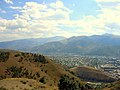
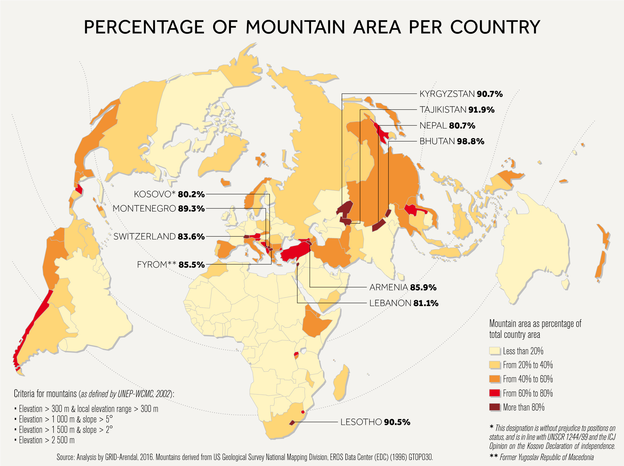
Armenia has a territorial area of 29,743 կիլոմետր քառակուսիs (11,484 sq mi). The terrain is mostly mountainous, with fast flowing rivers, and few forests. The land rises to 4,090 metres (13,419 feet) above sea level at Mount Aragats, and no point is below 390 metres (1,280 ft) above sea level.[8] Average elevation of the country area is 10th highest in the world and it has 85.9% mountain area, more than Switzerland or Nepal.[9]
- Mount Ararat
Mount Ararat, which was historically part of Armenia, is the highest mountain in the region at 5,137 meters (16,854 feet). Now located in Turkey, but clearly visible from Armenia, it is regarded by the Armenians as a symbol of their land. Because of this, the mountain is present on the Armenian national emblem today.[10][11][12]
Climate[խմբագրել | խմբագրել կոդը]

The climate in Armenia is markedly highland continental. Summers are hot, dry and sunny, lasting from June to mid-September. The temperature fluctuates between 22 and 36 °C (72 and 97 °F). However, the low humidity level mitigates the effect of high temperatures. Evening breezes blowing down the mountains provide a welcome refreshing and cooling effect. Springs are short, while autumns are long. Autumns are known for their vibrant and colourful foliage.
Winters are quite cold with plenty of snow, with temperatures ranging between −10 and −5 °C (14 and 23 °F). Winter sports enthusiasts enjoy skiing down the hills of Tsakhkadzor, located thirty minutes outside Yerevan. Lake Sevan, nestled up in the Armenian highlands, is the second largest lake in the world relative to its altitude, at 1,900 metres (6,234 ft) above sea level.
Environment[խմբագրել | խմբագրել կոդը]

Armenia ranked 63rd out of 180 countries on Environmental Performance Index (EPI) in 2018. Its rank on subindex Environmental Health (which is weighted at 40% in EPI) is 109, while Armenia's rank on subindex of Ecosystem Vitality (weighted at 60% in EPI) is 27th best in the world.[14] This suggests that main environmental issues in Armenia are with population health, while environment vitality is of lesser concern. Out of sub-subindices contributing to Environmental Health subindex ranking on Air Quality to which population is exposed is particularly unsatisfying.
Waste management in Armenia is underdeveloped, as no waste sorting or recycling takes place at Armenia's 60 landfills. A waste processing plant is scheduled for construction near Hrazdan city, which will allow for closure of 10 waste dumps.[15]
Despite the availability of abundant renewable energy sources in Armenia (especially hydroelectric and wind power) and calls from EU officials to shut down the nuclear power plant at Metsamor,[16] the Armenian Government is exploring the possibilities of installing new small modular nuclear reactors. In 2018 existing nuclear plant is scheduled for modernization to enhance its safety and increase power production by about 10%.[17][18]
Ծանոթագրություններ[խմբագրել | խմբագրել կոդը]
- ↑ "Armenia Արխիվացված 10 Դեկտեմբեր 2015 Wayback Machine." Dictionary.com Unabridged. 2015.
- ↑ 2,0 2,1 2,2 2,3 The Oxford Encyclopedia of Economic History. Oxford University Press. 2003. էջ 156. ISBN 978-0-19-510507-0.
- ↑ "[https://www.lexico.com/definition/multiple_image
- ↑ «Multiple Image». Lexico Dictionaries (անգլերեն). Վերցված է 2021-02-15-ին.
{{cite web}}: Text "Definition of Multiple Image by Oxford Dictionary on Lexico.com also meaning of Multiple Image" ignored (օգնություն); Text "English" ignored (օգնություն) - ↑ Central Intelligence Agency (2014). The CIA World Factbook 2015. Skyhorse Publishing. էջ 5241. ISBN 978-1-62914-903-5.
- ↑ Քաղվածելու սխալ՝ Սխալ
<ref>պիտակ՝ «classification of world regions» անվանումով ref-երը տեքստ չեն պարունակում: - ↑ Dinerstein, Eric; Olson, David; Joshi, Anup; Vynne, Carly; Burgess, Neil D.; Wikramanayake, Eric; Hahn, Nathan; Palminteri, Suzanne; Hedao, Prashant; Noss, Reed; Hansen, Matt; Locke, Harvey; Ellis, Erle C; Jones, Benjamin; Barber, Charles Victor; Hayes, Randy; Kormos, Cyril; Martin, Vance; Crist, Eileen; Sechrest, Wes; Price, Lori; Baillie, Jonathan E. M.; Weeden, Don; Suckling, Kierán; Davis, Crystal; Sizer, Nigel; Moore, Rebecca; Thau, David; Birch, Tanya; Potapov, Peter; Turubanova, Svetlana; Tyukavina, Alexandra; de Souza, Nadia; Pintea, Lilian; Brito, José C.; Llewellyn, Othman A.; Miller, Anthony G.; Patzelt, Annette; Ghazanfar, Shahina A.; Timberlake, Jonathan; Klöser, Heinz; Shennan-Farpón, Yara; Kindt, Roeland; Lillesø, Jens-Peter Barnekow; van Breugel, Paulo; Graudal, Lars; Voge, Maianna; Al-Shammari, Khalaf F.; Saleem, Muhammad (2017). «An Ecoregion-Based Approach to Protecting Half the Terrestrial Realm». BioScience. 67 (6): 534–545. doi:10.1093/biosci/bix014. ISSN 0006-3568.
- ↑ «Geographic Characteristic of The Republic of Armenia» (PDF). Marzes of the Republic of Armenia in Figures, 2002–2006. National Statistical Service of the Republic of Armenia. 2007. Արխիվացված (PDF) օրիգինալից 25 March 2009-ին. Վերցված է 22 July 2009-ին.
- ↑ «Percentage of Mountain Area per Country (map)». Արխիվացված օրիգինալից 9 January 2019-ին.
- ↑ Natasha May Azarian (2007). The Seeds of Memory: Narrative Renditions of the Armenian Genocide Across Generations. էջ 96. ISBN 978-0-549-53005-3. Արխիվացված օրիգինալից 28 May 2013-ին. Վերցված է 28 April 2013-ին. «Mount Ararat is considered the 'heart' of historical Armenia as it is Armenian folklore which considers the majestic mountain to be the place where Noah's Arc landed. Armenian businesses, households, and schools almost ubiquitously have at ...»
- ↑ Rouben Paul Adalian (13 May 2010). Historical Dictionary of Armenia. Scarecrow Press. էջ 85. ISBN 978-0-8108-7450-3. Արխիվացված օրիգինալից 28 May 2013-ին. Վերցված է 28 April 2013-ին. «Although the mythology associated with the pagan worship of the mountain is now lost to popular belief, Mount Ararat has played a very ...»
- ↑ James Minahan (1998). Miniature empires: a historical dictionary of the newly independent states. Greenwood Publishing Group. էջեր 2–3. ISBN 978-0-313-30610-5. Արխիվացված օրիգինալից 28 May 2013-ին. Վերցված է 28 April 2013-ին. «Mount Ararat, the legendary landing place of Noah's Ark, is located in what is now modern Turkey. Situated near the border, the peak is visible from nearly every area of Armenia. Historically, the mountain has been the Armenian people's most ...»
- ↑ Beck, Hylke E.; Zimmermann, Niklaus E.; McVicar, Tim R.; Vergopolan, Noemi; Berg, Alexis; Wood, Eric F. (30 October 2018). «Present and future Köppen-Geiger climate classification maps at 1-km resolution» (PDF). Scientific Data. 5: 180214. Bibcode:2018NatSD...580214B. doi:10.1038/sdata.2018.214. PMC 6207062. PMID 30375988. Վերցված է 6 September 2019-ին.
- ↑ «Environmental Performance Index». epi.envirocenter.yale.edu (անգլերեն). Արխիվացված է օրիգինալից 16 October 2019-ին. Վերցված է 2 February 2018-ին.
- ↑ «"We have good reasons to boast economic growth in the coming years" – Karen Karapetyan Pleased with 2017 Indices in Kotayk Marz». www.gov.am (անգլերեն). Արխիվացված է օրիգինալից 16 February 2018-ին. Վերցված է 16 February 2018-ին.
- ↑ «EU: Armenia nuclear plant should be shut down as soon as possible». news.am (անգլերեն). Արխիվացված է օրիգինալից 16 February 2018-ին. Վերցված է 16 February 2018-ին.
- ↑ «Modernization to increase the capacity of Armenian nuclear power plant by 10%». arka.am. Արխիվացված օրիգինալից 16 February 2018-ին. Վերցված է 16 February 2018-ին.
- ↑ «Armenian Nuclear Power Plant upgrading program to continue in 2018». armenpress.am (անգլերեն). Արխիվացված է օրիգինալից 16 February 2018-ին. Վերցված է 16 February 2018-ին.
Պատկերասրահ[խմբագրել | խմբագրել կոդը]
-
 Հայաստան
 -
 Խոր Վիրապ
 -
 եկեղեցի
 -
 Վաղարշապատ
 -
 Վանաձոր
 -
 Գյումրի
 -
 Երևան
Երևան -
 Հայաստան
 -
 Սփյուռք


