
Պատկեր:Krim 2014 de.svg

Size of this PNG preview of this SVG file: 665 × 441 պիքսել. Այլ թույլտվությաններ: 320 × 212 պիքսել | 640 × 424 պիքսել | 1024 × 679 պիքսել | 1280 × 849 պիքսել | 2560 × 1698 պիքսել.
Սկզբնական նիշք (SVG-նիշք, անվանապես 665 × 441 փիքսել, նիշքի չափը՝ 103 ԿԲ)
Ամփոփում
| Նկարագրում |
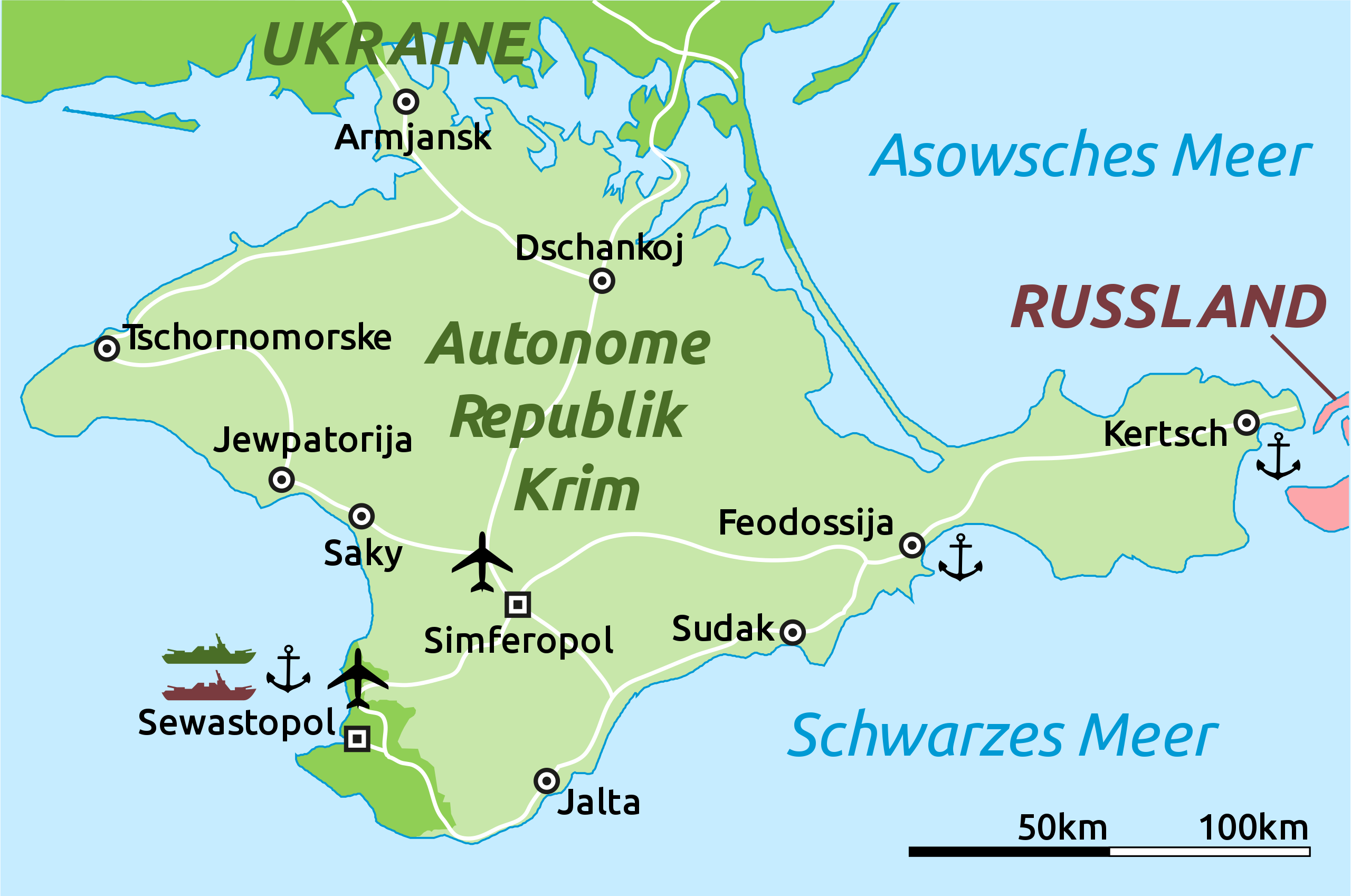
Deutsch: Karte der Krim-Republik.
English: Map of the Autonomous Republic of Crimea and of Sevastopol, Ukraine. |
| Թվական | |
| Աղբյուր |
This file was derived from : |
| Հեղինակ |
Original: Վեկտոր: |
| Այլ մեկնակերպներ |
|
| SVG genesis | Այս մասշտաբավորելի վեկտորային գրաֆիկայի նիշքի ելակետային կոդը վավեր է. Սա վեկտոր գրաֆիկական պատկեր է ստեղծված է եղել Adobe Illustrator օգնությամբ: . |

Արտոնագրում
Ես, սույն աշխատանքի հեղինակային իրավունքների տերը, այսուհետ այն հրատարակում եմ հետևյալ արտոնագրի ներքո։
| This file is made available under the Creative Commons CC0 1.0 Universal Public Domain Dedication. | |
| The person who associated a work with this deed has dedicated the work to the public domain by waiving all of their rights to the work worldwide under copyright law, including all related and neighboring rights, to the extent allowed by law. You can copy, modify, distribute and perform the work, even for commercial purposes, all without asking permission.
|
Original upload log
This image is a derivative work of the following images:
- Crimea republic map.png licensed with Cc-zero
- 2012-09-06T09:53:36Z PANONIAN 1031x684 (62218 Bytes) corrected Sevastopol border
- 2012-08-30T11:55:15Z PANONIAN 1031x684 (61885 Bytes) {{Information |Description=Map of the Autonomous Republic Crimea, Ukraine. |Source={{own}} |Date=2012 |Author= [[User:PANONIAN|PANONIAN]] |Permission= |other_versions= }}
Uploaded with derivativeFX
Նիշքի պատմություն
Մատնահարեք օրվան/ժամին՝ նիշքի այդ պահին տեսքը դիտելու համար։
| Օր/Ժամ | Մանրապատկեր | Օբյեկտի չափը | Մասնակից | Մեկնաբանություն | |
|---|---|---|---|---|---|
| ընթացիկ | 16:52, 5 Մարտի 2014 | | 665 × 441 (103 ԿԲ) | Schwarzorange | moved "Saky" closer to Saky |
| 19:10, 4 Մարտի 2014 |  | 665 × 441 (103 ԿԲ) | Martin Kraft | Maßstab, +Tschornomorske, diverse kleiner Optimierungen | |
| 10:37, 4 Մարտի 2014 |  | 665 × 441 (103 ԿԲ) | Martin Kraft | Dzhankoi -> Dschankoj | |
| 11:25, 3 Մարտի 2014 |  | 665 × 441 (103 ԿԲ) | Martin Kraft | Straßen, weiter Städte, Farben | |
| 08:39, 3 Մարտի 2014 |  | 665 × 441 (105 ԿԲ) | Martin Kraft | Pfade aufgeräumt. Dateigröße halbiert. | |
| 07:42, 3 Մարտի 2014 |  | 665 × 441 (229 ԿԲ) | Furfur | Sinferopol -> Simferopol | |
| 22:39, 2 Մարտի 2014 |  | 665 × 441 (225 ԿԲ) | Martin Kraft | +Flughafen | |
| 22:27, 2 Մարտի 2014 |  | 665 × 441 (226 ԿԲ) | Martin Kraft | Ohne Schraffur ist doch irgendwie besser | |
| 22:14, 2 Մարտի 2014 |  | 665 × 441 (230 ԿԲ) | Martin Kraft | Karte komplett überarbeitet. Bei Nichtgefallen einfach revertieren, dann stelle ich sie seperat ein | |
| 20:44, 2 Մարտի 2014 |  | 665 × 441 (313 ԿԲ) | Furfur | verbessert |
Նիշքի օգտագործում
Այս նիշքին օգտագործող էջեր չկան։
Նիշքի համընդհանուր օգտագործում
Հետևյալ այլ վիքիները օգտագործում են այս նիշքը՝
- Օգտագործումը de.wikipedia.org կայքում
- Օգտագործումը fr.wikipedia.org կայքում
- Օգտագործումը sr.wikinews.org կայքում