
Պատկեր:Worldmaphedo.jpg
Ավելի բարձր կետաչափով տարբերակ չկա։
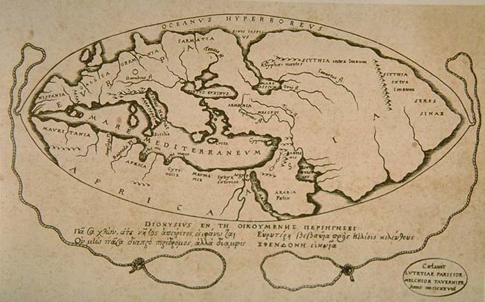
Worldmaphedo.jpg (700 × 437 փիքսել, նիշքի չափը՝ 57 ԿԲ, MIME-տեսակը՝ image/jpeg)
Ամփոփում
| Նկարագրում |
English: World map according to ideas by Posidonius (150-130 B.C.), drawn by 16th century cartographers Petrus Bertius & Melchior Tavernier in 1628. Many of the details in this map couldn't have been known by Posidonius, rather, Bertius and Tavernier show Posidonius' ideas about the positions of the continents. |
|||||||||||||||||||||||||||||||||||||||||||||
| Թվական | ||||||||||||||||||||||||||||||||||||||||||||||
| Աղբյուր | Armenica | |||||||||||||||||||||||||||||||||||||||||||||
| Հեղինակ |
|
|||||||||||||||||||||||||||||||||||||||||||||
| Այլ մեկնակերպներ |
|
|||||||||||||||||||||||||||||||||||||||||||||


,_hoc_est,_fvnda_Posidonii._LOC_97690010.jpg)

Արտոնագրում
|
This work is in the public domain in its country of origin and other countries and areas where the copyright term is the author's life plus 100 years or fewer. This work is in the public domain in the United States because it was published (or registered with the U.S. Copyright Office) before January 1, 1929. | |
| This file has been identified as being free of known restrictions under copyright law, including all related and neighboring rights. | |
Original upload log
Transferred from en.wikipedia to Commons by Woudloper using CommonsHelper.
The original description page was here. All following user names refer to en.wikipedia.
- 2007-02-08 14:26 Artaxiad 700×437×8 (57932 bytes) World map according to Posidonius (150-130 B.C.) {{GFDL-Armenica}}
Նիշքի պատմություն
Մատնահարեք օրվան/ժամին՝ նիշքի այդ պահին տեսքը դիտելու համար։
| Օր/Ժամ | Մանրապատկեր | Օբյեկտի չափը | Մասնակից | Մեկնաբանություն | |
|---|---|---|---|---|---|
| ընթացիկ | 15:22, 20 Մայիսի 2008 | | 700 × 437 (57 ԿԲ) | Woudloper | {{Information |Description={{en|World map according to Posidonius (150-130 B.C.) Source: http://www.armenica.org/cgi-bin/history/en/getHistory.cgi?3=1==Historical%20maps==1=3=AAA}} |Source=Transferred from [http://en.wikipedia.org en.wikipedia]; transfer |
Նիշքի օգտագործում
Հետևյալ 2 էջերը հղվում են այս նիշքին՝
Նիշքի համընդհանուր օգտագործում
Հետևյալ այլ վիքիները օգտագործում են այս նիշքը՝
- Օգտագործումը af.wikipedia.org կայքում
- Օգտագործումը bn.wikipedia.org կայքում
- Օգտագործումը bs.wikipedia.org կայքում
- Օգտագործումը ca.wikipedia.org կայքում
- Օգտագործումը cs.wikipedia.org կայքում
- Օգտագործումը de.wikipedia.org կայքում
- Օգտագործումը en.wikipedia.org կայքում
- Օգտագործումը es.wikipedia.org կայքում
- Օգտագործումը fa.wikipedia.org կայքում
- Օգտագործումը fr.wikipedia.org կայքում
- Օգտագործումը ha.wikipedia.org կայքում
- Օգտագործումը he.wikipedia.org կայքում
- Օգտագործումը hi.wikibooks.org կայքում
- Օգտագործումը hr.wikipedia.org կայքում
- Օգտագործումը it.wikipedia.org կայքում
- Օգտագործումը ja.wikipedia.org կայքում
- Օգտագործումը lv.wikipedia.org կայքում
- Օգտագործումը nl.wikipedia.org կայքում
- Օգտագործումը no.wikipedia.org կայքում
- Օգտագործումը pnb.wikipedia.org կայքում
- Օգտագործումը sh.wikipedia.org կայքում
- Օգտագործումը sl.wikipedia.org կայքում
- Օգտագործումը sr.wikipedia.org կայքում
- Օգտագործումը th.wikipedia.org կայքում
- Օգտագործումը uk.wikipedia.org կայքում
- Օգտագործումը ur.wikipedia.org կայքում
- Օգտագործումը zh.wikipedia.org կայքում