
Պատկեր:Virginia and Florida by W. Blaeu (MAM, Madrid, 413) 01.jpg
Նախադիտման չափ՝ 793 × 600 պիքսել։ Այլ թույլտվությաններ: 317 × 240 պիքսել | 635 × 480 պիքսել | 1015 × 768 պիքսել | 1280 × 968 պիքսել | 2560 × 1936 պիքսել | 3120 × 2360 պիքսել.
Սկզբնական նիշք (3120 × 2360 փիքսել, նիշքի չափը՝ 2,36 ՄԲ, MIME-տեսակը՝ image/jpeg)
| Description |
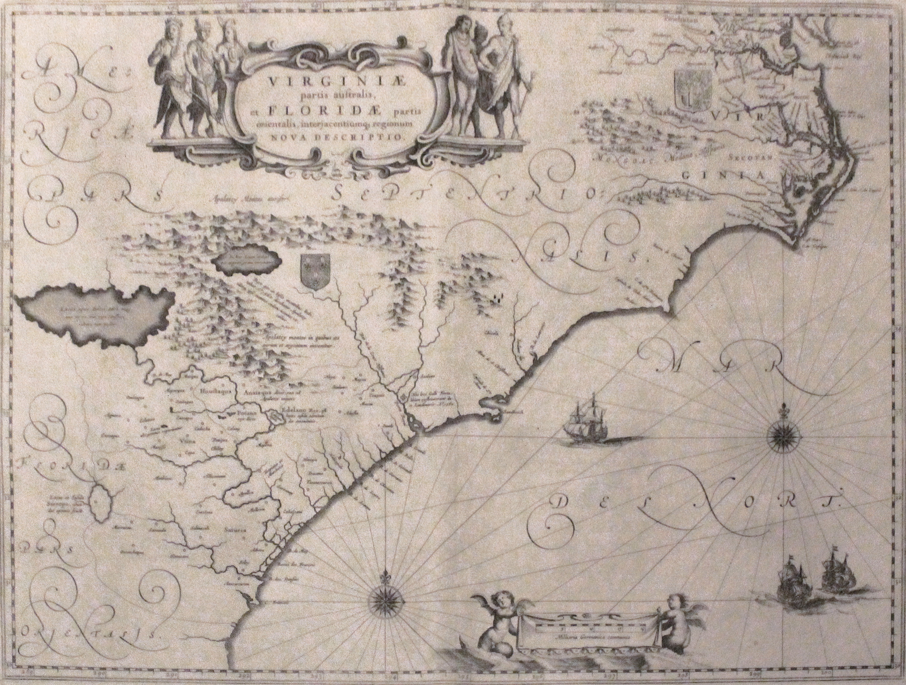
English: Map depicting the former Colony of Virginia (according to the Second Charter) and part of Florida.
Español: Mapa que muestra la antigua Colonia de Virginia (según la Segunda Carta) y parte de Florida. |
||||||||||||||||||||||||||
| Թվական | 1609 - 1638 | ||||||||||||||||||||||||||
| Աղբյուր | Լուսանկար: Luis García (Zaqarbal), 12 Սեպտեմբեր 2013. | ||||||||||||||||||||||||||
| Ստեղծել է |
|
||||||||||||||||||||||||||
| Իրավունքներ (Նիշքի վերաօգտագործումը) |
|
||||||||||||||||||||||||||
| Geotemporal data | |||||||||||||||||||||||||||
| Պատկերման ամսաթիվ | 1609 - 1638 | ||||||||||||||||||||||||||
| Map location |
English: Nowadays Virgina, North Carolina, South Carolina, Georgia and north of Florida.
Español: Los actuales estados de Virginia, Carolina del Norte, Carolina del Sur, Georgia y norte de Florida. |
||||||||||||||||||||||||||
| Georeferencing | If inappropriate please set warp_status = skip to hide. | ||||||||||||||||||||||||||
| Bibliographic data | |||||||||||||||||||||||||||
| Լեզու | լատիներեն | ||||||||||||||||||||||||||
| Archival data | |||||||||||||||||||||||||||
| Հավաքածու |
|
||||||||||||||||||||||||||
| ID |
413 |
||||||||||||||||||||||||||
| Չափեր | բարձրություն: 382 cm; լայնություն: 503 cm | ||||||||||||||||||||||||||
| Տեխնիկա | paper | ||||||||||||||||||||||||||
| Ծանոթագրություններ | Museum's website – Web del museo – Site du musée | ||||||||||||||||||||||||||


_01.jpg)
Նիշքի պատմություն
Մատնահարեք օրվան/ժամին՝ նիշքի այդ պահին տեսքը դիտելու համար։
| Օր/Ժամ | Մանրապատկեր | Օբյեկտի չափը | Մասնակից | Մեկնաբանություն | |
|---|---|---|---|---|---|
| ընթացիկ | 17:53, 29 հունվարի 2016 | | 3120 × 2360 (2,36 ՄԲ) | Zaqarbal | Photo taken by Luis García (Zaqarbal) on September 12th, 2013. Hereby released into the public domain. |
| 17:44, 29 հունվարի 2016 |  | 3120 × 2360 (2,36 ՄԲ) | Zaqarbal | Photo taken by Luis García (Zaqarbal) on September 12th, 2013. Hereby published under GFDL and Cc-by-sa-3.0-ES licenses. |
Նիշքի օգտագործում
Հետևյալ 2 էջերը հղվում են այս նիշքին՝
Նիշքի համընդհանուր օգտագործում
Հետևյալ այլ վիքիները օգտագործում են այս նիշքը՝
- Օգտագործումը ar.wikipedia.org կայքում
- Օգտագործումը en.wikipedia.org կայքում
- Օգտագործումը pl.wikipedia.org կայքում
_01.jpg)