
Պատկեր:Republic of Artsakh (orthographic projection) v1.png
Նախադիտման չափ՝ 603 × 599 պիքսել։ Այլ թույլտվությաններ: 242 × 240 պիքսել | 617 × 613 պիքսել.
Սկզբնական նիշք (617 × 613 փիքսել, նիշքի չափը՝ 120 ԿԲ, MIME-տեսակը՝ image/png)
_v1.png)
| Նկարագրում |
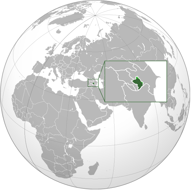
English: Orthographic Projection Map of the Nagorno-Karabakh Republic Dark Green represents areas under ethnic Armenian military control, light green represents areas claimed by the republic, under Azerbaijan government control. |
| Թվական | (UTC) |
| Աղբյուր | |
| Հեղինակ |
|
.svg)
| Սա խմբագրված պատկեր է, որը համեմատ բնօրինակին ենթարկվել է թվային մշակման։ Փոփոխությունները՝ made the location of NKR more clear on the world map: Սկզբնական պատկերը գտնվում է այստեղ՝ Nagorno-Karabakh Republic (orthographic projection).svg։ Խմբագրել է Ashot Arzumanyan մասնակիցը։
|
| Այս պատկերը հեղինակային իրավունքներով չի պաշտպանվում, որովհետև փծուն է, գեղարվեստական արժեք չունի, բաղկացած է միայն հանրահայտ տարրերից, ուրոնք հեղինակ չունեն: |
Original upload log
This image is a derivative work of the following images:
- File:Nagorno-Karabakh_Republic_(orthographic_projection).svg licensed with PD-ineligible
- 2010-02-23T00:53:47Z Kentronhayastan 550x550 (594491 Bytes) cleaned up the fixed borders
- 2010-02-21T11:04:39Z Dinamik 550x550 (655950 Bytes) some more information about territory
- 2010-02-12T12:42:58Z Justass 550x550 (586396 Bytes) Reverted to version as of 10:24, 27 January 2010
- 2010-02-12T12:40:31Z Maulucioni 550x550 (105958 Bytes) to png
- 2010-01-27T10:24:54Z Kentronhayastan 550x550 (586396 Bytes) adjusted map size
- 2010-01-27T10:19:16Z Kentronhayastan 550x550 (586344 Bytes) {{Information |Description={{en|1=Orthographic Projection Map of the Nagorno-Karabakh Republic}} |Source=Ssolbergj's work |Author=kentronhayastan, Ssolbergj |Date= |Permission= |other_versions= }}
Uploaded with derivativeFX
Նիշքի պատմություն
Մատնահարեք օրվան/ժամին՝ նիշքի այդ պահին տեսքը դիտելու համար։
| Օր/Ժամ | Մանրապատկեր | Օբյեկտի չափը | Մասնակից | Մեկնաբանություն | |
|---|---|---|---|---|---|
| ընթացիկ | 18:46, 11 հունվարի 2011 | | 617 × 613 (120 ԿԲ) | Ashot Arzumanyan | {{Information |Description={{en|1=Orthographic Projection Map of the Nagorno-Karabakh Republic}} Dark Green represents areas under ethnic Armenian military control, light green represents areas claimed by the republic, under Azerbaijan government control. |
Նիշքի օգտագործում
Հետևյալ էջը հղվում է այս նիշքին՝
Նիշքի համընդհանուր օգտագործում
Հետևյալ այլ վիքիները օգտագործում են այս նիշքը՝
- Օգտագործումը en.wikipedia.org կայքում
- Օգտագործումը fa.wikipedia.org կայքում
_v1.png)