
Պատկեր:Old Town, St. Mary's - geograph.org.uk - 929131.jpg
Ավելի բարձր կետաչափով տարբերակ չկա։
Old_Town,_St._Mary's_-_geograph.org.uk_-_929131.jpg (640 × 500 փիքսել, նիշքի չափը՝ 343 ԿԲ, MIME-տեսակը՝ image/jpeg)
Ամփոփում
| Նկարագրում |
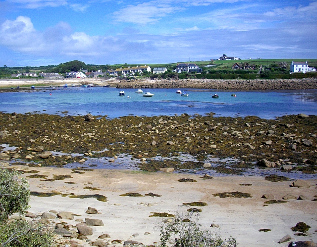
English: Old Town, St. Mary's Known as Porthennor when, in Medieval times, this was the most important harbour on Ennor (as the island of St. Mary's was then known). The tree covered lump on the horizon (left) is the site of the 13th century castle. An annual rent of 8d or 300 puffins was to be paid to the crown for this. The airport buildings can be seen on the right hand horizon. |
| Թվական | |
| Աղբյուր | From geograph.org.uk |
| Հեղինակ | Bob Embleton |
| Հղում (required by the license) | Bob Embleton / Old Town, St. Mary's / |
| Տեսախցիկի տեղագրություն | | Այս և ուրիշ պատկերներ իրենց տեղագրությամբ OpenStreetMap |
|---|
_heading:67.00&language=hy)
| Օբյեկտի տեղագրություն | | Այս և ուրիշ պատկերներ իրենց տեղագրությամբ OpenStreetMap |
|---|
_heading:67.00&language=hy)
Արտոնագրում

|
This image was taken from the Geograph project collection. See this photograph's page on the Geograph website for the photographer's contact details. The copyright on this image is owned by Bob Embleton and is licensed for reuse under the Creative Commons Attribution-ShareAlike 2.0 license.
|
This file is licensed under the Creative Commons Attribution-Share Alike 2.0 Generic license.
Հղում: Bob Embleton
- Դուք ազատ եք՝
- կիսվել ստեղծագործությամբ – պատճենել, տարածել և փոխանցել այս աշխատանքը։
- վերափոխել – ադապտացնել աշխատանքը
- Պահպանելով հետևյալ պայմանները'
- հղում – Դուք պետք է նշեք հեղինակի (իրավատիրոջ) հղումը:
- համանման տարածում – Եթե դուք ձևափոխում եք, փոխակերպում, կամ այս աշխատանքի հիման վրա ստեղծում եք նոր աշխատանք, ապա ձեր ստեղծածը կարող է տարածվել միայն նույն կամ համարժեք թույլատրագրով։
Նիշքի պատմություն
Մատնահարեք օրվան/ժամին՝ նիշքի այդ պահին տեսքը դիտելու համար։
| Օր/Ժամ | Մանրապատկեր | Օբյեկտի չափը | Մասնակից | Մեկնաբանություն | |
|---|---|---|---|---|---|
| ընթացիկ | 03:29, 22 փետրվարի 2011 | | 640 × 500 (343 ԿԲ) | GeographBot | == {{int:filedesc}} == {{Information |description={{en|1=Old Town, St. Mary's Known as Porthennor when, in Medieval times, this was the most important harbour on Ennor (as the island of St. Mary's was then known). The tree covered lump on the horizon (lef |
Նիշքի օգտագործում
Հետևյալ էջը հղվում է այս նիշքին՝
Նիշքի համընդհանուր օգտագործում
Հետևյալ այլ վիքիները օգտագործում են այս նիշքը՝
- Օգտագործումը en.wikipedia.org կայքում
- Օգտագործումը eu.wikipedia.org կայքում
- Օգտագործումը it.wikipedia.org կայքում