
Պատկեր:NATO and the Warsaw Pact 1973.svg

Size of this PNG preview of this SVG file: 450 × 456 պիքսել. Այլ թույլտվությաններ: 237 × 240 պիքսել | 474 × 480 պիքսել | 758 × 768 պիքսել | 1011 × 1024 պիքսել | 2021 × 2048 պիքսել.
Սկզբնական նիշք (SVG-նիշք, անվանապես 450 × 456 փիքսել, նիշքի չափը՝ 478 ԿԲ)
Ամփոփում


.svg)
.svg)
.svg)
.svg)
.svg)


.svg)
.svg)
.svg)


.png)
.png)


.svg)


.svg)

.svg)


.svg)
.svg)
.svg)
.svg)


.svg)
.png)


.svg)


.svg)
.svg)


.svg)


.svg)


.svg)
.svg)
.svg)
.svg)
.svg)
.svg)
.svg)
_cropped.svg)
.svg)
.svg)
.svg)
.svg)
.svg)
.svg)
.svg)
.svg)
.svg)
.svg)
.svg)
.svg)
.svg)
.svg)
.svg)
.svg)
.svg)
.svg)
.svg)
.svg)
.svg)
.svg)
.svg)
.svg)
.svg)
.svg)
.svg)
.svg)
.svg)
.svg)
.svg)
.svg)
.svg)
.svg)
.svg)
.svg)
.svg)
.svg)
.svg)
.svg)
.svg)
.svg)
.svg)
.svg)
.svg)
Արտոնագրում
Ես, սույն աշխատանքի հեղինակային իրավունքների տերը, այսուհետ այն հրատարակում եմ հետևյալ արտոնագրի ներքո։
Այս նիշքը հասանելի է Creative Commons Attribution-Share Alike 3.0 Unported արտոնագրի ներքո:
- Դուք ազատ եք՝
- կիսվել ստեղծագործությամբ – պատճենել, տարածել և փոխանցել այս աշխատանքը։
- վերափոխել – ադապտացնել աշխատանքը
- Պահպանելով հետևյալ պայմանները'
- հղում – Դուք պետք է նշեք հեղինակի (իրավատիրոջ) հղումը:
- համանման տարածում – Եթե դուք ձևափոխում եք, փոխակերպում, կամ այս աշխատանքի հիման վրա ստեղծում եք նոր աշխատանք, ապա ձեր ստեղծածը կարող է տարածվել միայն նույն կամ համարժեք թույլատրագրով։
Original upload log
This image is a derivative work of the following images:
- File:Blank_map_of_Europe_1956-1990.svg licensed with Cc-by-sa-3.0
- 2011-10-30T04:43:42Z Alphathon 450x456 (485146 Bytes) == {{int:filedesc}} == {{Information |Description={{en|Blank map of Europe showing national borders as they stood from 1956-1990.}} |Source=*[[:File:Blank_map_of_Europe.svg|]] |Date=2011-10-30 04:42 (UTC) |Author=*[[:File:Bla
Uploaded with derivativeFX
Նիշքի պատմություն
Մատնահարեք օրվան/ժամին՝ նիշքի այդ պահին տեսքը դիտելու համար։
| Օր/Ժամ | Մանրապատկեր | Օբյեկտի չափը | Մասնակից | Մեկնաբանություն | |
|---|---|---|---|---|---|
| ընթացիկ | 09:17, 22 Հուլիսի 2022 | | 450 × 456 (478 ԿԲ) | Kwamikagami | change to NATO blue; Liecht. not a member |
| 06:43, 30 Հունիսի 2016 |  | 450 × 456 (477 ԿԲ) | FreshCorp619 | Reverted to version as of 18:32, 25 February 2012 (UTC) | |
| 06:42, 30 Հունիսի 2016 |  | 450 × 456 (728 ԿԲ) | FreshCorp619 | fixed errors | |
| 06:38, 30 Հունիսի 2016 |  | 450 × 456 (707 ԿԲ) | FreshCorp619 | Added Byelorussian and Ukrainian SSRs (UN Members) | |
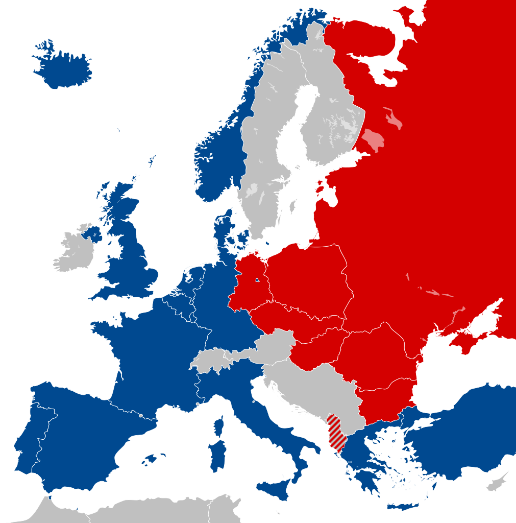
| 18:32, 25 փետրվարի 2012 |  | 450 × 456 (477 ԿԲ) | Alphathon | == {{int:filedesc}} == {{Information |Description={{en|Map of Europe showing NATO and the Warsaw Pact circa 1973.}} |Source={{Derived from|Blank_map_of_Europe_1956-1990.svg|display=50}} |Date=2012-02-25 18:31 (UTC) |Aut... |
Նիշքի օգտագործում
Հետևյալ էջը հղվում է այս նիշքին՝
Նիշքի համընդհանուր օգտագործում
Հետևյալ այլ վիքիները օգտագործում են այս նիշքը՝
- Օգտագործումը als.wikipedia.org կայքում
- Օգտագործումը ar.wikipedia.org կայքում
- Օգտագործումը ca.wikipedia.org կայքում
- Unió de Repúbliques Socialistes Soviètiques
- República Democràtica Alemanya
- República Socialista Federativa Soviètica de Rússia
- República Federal Socialista de Iugoslàvia
- Pacte de Varsòvia
- Consell d'Assistència Econòmica Mútua
- Bloc de l'Est
- República Popular d'Albània
- República Socialista de Romania
- República Democràtica de Finlàndia
- Història de la Unió Soviètica (1985-1991)
- Història de la Unió Soviètica (1953-1985)
- República Popular de Polònia
- Plantilla:Europa Oriental Comunista
- Història de la Unió Soviètica i la Rússia Soviètica (1917-1927)
- Economia de la Unió Soviètica
- Doctrina Bréjnev
- República Popular d'Hongria
- República Popular de Bulgària
- República Socialista Txecoslovaca
- Ampliació de la Unió Europea de 2004
- Օգտագործումը de.wikipedia.org կայքում
- Օգտագործումը el.wikipedia.org կայքում
- Օգտագործումը en.wikipedia.org կայքում
- History of the Soviet Union (1982–1991)
- East Germany
- Warsaw Pact
- History of Soviet Russia and the Soviet Union (1917–1927)
- Byelorussian Soviet Socialist Republic
- History of the Soviet Union (1953–1964)
- Socialist Republic of Romania
- Democratic Federal Yugoslavia
- Socialist Federal Republic of Yugoslavia
- Polish People's Republic
- Ukrainian Soviet Socialist Republic
- History of Czechoslovakia (1948–1989)
- History of the Soviet Union (1927–1953)
- History of Poland (1945–1989)
- Czechoslovak Socialist Republic
- Template:Communist Eastern and Central Europe
- People's Republic of Bulgaria
- Hungarian People's Republic
- History of East Germany
- People's Socialist Republic of Albania
- History of the Soviet Union (1964–1982)
- User:Peterstrempel/Soviet-Brezhnev-draft
- History of the Soviet Union
- History of NATO
- User:Y-S.Ko/Wikipedia course/History
Տեսնել այս նիշքի ավելի համընդհանուր օգտագործումը: