
Պատկեր:Moyen Orient Amarna 1.svg

Սկզբնական նիշք (SVG-նիշք, անվանապես 1885 × 1354 փիքսել, նիշքի չափը՝ 4,02 ՄԲ)

|
Այս SVG ֆայլ օգտագործում է զետեղված տեքստ, որը կարելի է հեշտ թարգմանել ձեր լեզվի վրա using [toolforge:svgtranslate/File:Moyen_Orient_Amarna_1.svglink this automated tool]: Իմացեք ավելին: You can also download it and translate it manually using a text editor. |
| Նկարագրում |
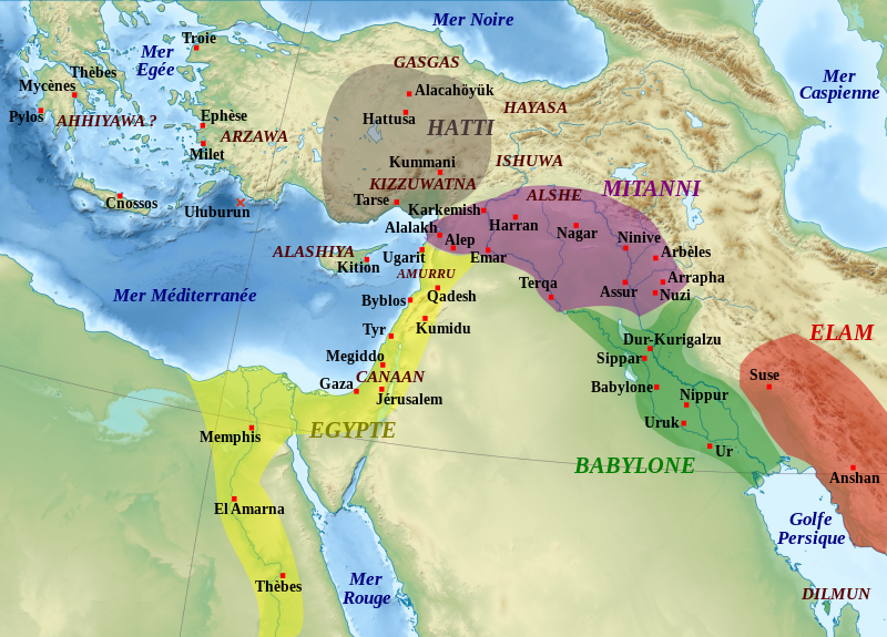
English: Map of the Middle East in the beginning of the Amarna letters period, the first half of the 14th century BC. The extension of the dominions of the great kingdoms is approximate. Remarks : the extension of the Arzawa is not shown because of its uncertainty, it may have covered the main part of Western Anatolia ; the Ahhiyawa are here supposed to be the "Mycaneans" ; the extension of Elam is very approximate. Español: Mapa de l'Orient Mitjà al començament del període de les cartes d'Amarna, la primera meitat del segle XIV aC. L'extensió dels dominis dels grans regnes és aproximada. Observacions: l'extensió de l'Arzawa no es mostra a causa de la seva incertesa, podria haver cobert la part principal de l'Anatòlia occidental ; els Ahhiyawa aquí se suposa que són els "micènics"; l'extensió d'Elam és molt aproximada. Français : Carte de la situation politique du Moyen-Orient au début de la période des Lettres d'Amarna, première moitié du XIVe siècle av. J.-C. L'extension des zones dominées par les grands royaumes est approximative. Remarques : l'extension de l'Arzawa n'est pas notée car trop incertaine, mais doit couvrir la majeure partie de l'Anatolie occidentale ; les Ahhiyawa sont considérés comme correspondant à la civilisation mycénienne ; l'extension de l'Elam est approximative. |
| Թվական | (UTC) |
| Աղբյուր | |
| Հեղինակ |
|
| Այլ մեկնակերպներ |
File:Moyen Orient Amarna 1.svg has 2 translations.
Other related versions: []
|


|
|
Այս SVG ֆայլ օգտագործում է զետեղված տեքստ, որը կարելի է հեշտ թարգմանել ձեր լեզվի վրա using [toolforge:svgtranslate/File:Moyen_Orient_Amarna_1.svglink this automated tool]: Իմացեք ավելին: You can also download it and translate it manually using a text editor. |
This file is translated using SVG For most Wikipedia projects, you can embed the file normally (without a To translate the text into your language, you can use the SVG Translate tool. Alternatively, you can download the file to your computer, add your translations using whatever software you're familiar with, and re-upload it with the same name. You will find help in Graphics Lab if you're not sure how to do this. |
| Սա խմբագրված պատկեր է, որը համեմատ բնօրինակին ենթարկվել է թվային մշակման։ Փոփոխությունները՝ Ajout des royaumes, sites archéologiques et régions.: Սկզբնական պատկերը գտնվում է այստեղ՝ Middle East topographic map-blank.svg։ Խմբագրել է Zunkir մասնակիցը։
|
- Դուք ազատ եք՝
- կիսվել ստեղծագործությամբ – պատճենել, տարածել և փոխանցել այս աշխատանքը։
- վերափոխել – ադապտացնել աշխատանքը
- Պահպանելով հետևյալ պայմանները'
- հղում – Դուք պետք է նշեք հեղինակի (իրավատիրոջ) հղումը:
- համանման տարածում – Եթե դուք ձևափոխում եք, փոխակերպում, կամ այս աշխատանքի հիման վրա ստեղծում եք նոր աշխատանք, ապա ձեր ստեղծածը կարող է տարածվել միայն նույն կամ համարժեք թույլատրագրով։

|
Այս վավերագրման պատճենահանման, տարածման և/կամ ձևափոխման թույլտվություն կամ լիցենզիայի GNU FDL պայմաններով 1.2 մեկնակերպի կամ ավելի ուշ, հրատարակված Ազատ ծրագրային ապահովության հիմնադրամում, առանց անփոփոխելի հատվածների, առանց բնագիրների, որոնք տեղադրված են առաջին և վերջին շապիկներում: Լիցենզիայի պատճենը գտնվում է GNU Free Documentation License հատվածում: |
Original upload log
This image is a derivative work of the following images:
- File:Middle_East_topographic_map-blank.svg licensed with Cc-by-sa-3.0,2.5,2.0,1.0, GFDL
- 2010-11-03T17:52:56Z Sémhur 3097x1938 (10510751 Bytes) == {{int:filedesc}} == {{Information |Description={{Multilingual description |en= Blank physical map of the [[:en:Middle East|Middle East]] |fr= Carte physique vierge du [[:fr:Moyen-Orient|Moyen-Orient]]. }} |Source={{own}}.
Uploaded with derivativeFX
Նիշքի պատմություն
Մատնահարեք օրվան/ժամին՝ նիշքի այդ պահին տեսքը դիտելու համար։
| Օր/Ժամ | Մանրապատկեր | Օբյեկտի չափը | Մասնակից | Մեկնաբանություն | |
|---|---|---|---|---|---|
| ընթացիկ | 18:58, 22 փետրվարի 2024 | | 1885 × 1354 (4,02 ՄԲ) | Manlleus | File uploaded using svgtranslate tool (https://svgtranslate.toolforge.org/). Added translation for ca. |
| 17:47, 22 փետրվարի 2024 |  | 1885 × 1354 (3,96 ՄԲ) | Manlleus | fixed text labels for translation | |
| 12:47, 19 Հոկտեմբերի 2020 |  | 1885 × 1354 (3,97 ՄԲ) | Rebblumstein | Reverted to version as of 14:58, 6 March 2016 (UTC) (Until I fix it more thoroughly) | |
| 12:02, 19 Հոկտեմբերի 2020 |  | 1885 × 1354 (3,97 ՄԲ) | Rebblumstein | Removed more nested <tspan> elements | |
| 11:50, 19 Հոկտեմբերի 2020 |  | 1885 × 1354 (3,97 ՄԲ) | Rebblumstein | Removed nested <tspan> elements | |
| 14:58, 6 Մարտի 2016 |  | 1885 × 1354 (3,97 ՄԲ) | Geagea | Reverted to version as of 20:28, 28 October 2011 (UTC) | |
| 14:57, 6 Մարտի 2016 |  | 1885 × 1354 (3,97 ՄԲ) | Geagea | Editing SVG source code using User:Rillke/SVGedit.js; upload handled by User:Rillke/MwJSBot.js | |
| 20:28, 28 Հոկտեմբերի 2011 |  | 1885 × 1354 (3,97 ՄԲ) | Zunkir | Police et remaniements mineurs. | |
| 19:30, 14 Նոյեմբերի 2010 |  | 1885 × 1354 (3,96 ՄԲ) | Zunkir | {{Information |Description={{Multilingual description |fr= Carte de la situation politique du Moyen-Orient au début de la période des Lettres d'Amarna, première moitié du XIVe siècle av. J.-C. L'extension des zones dominées par les grands royaumes e |
Նիշքի օգտագործում
Հետևյալ էջը հղվում է այս նիշքին՝
Նիշքի համընդհանուր օգտագործում
Հետևյալ այլ վիքիները օգտագործում են այս նիշքը՝
- Օգտագործումը ar.wikipedia.org կայքում
- Օգտագործումը ca.wikipedia.org կայքում
- Օգտագործումը de.wikipedia.org կայքում
- Օգտագործումը en.wikipedia.org կայքում
- Օգտագործումը es.wikipedia.org կայքում
- Օգտագործումը fr.wikipedia.org կայքում
- Pharaon
- Mésopotamie
- Hittites
- Kizzuwatna
- Hébreux
- Histoire de l'Irak
- Lettres d'Amarna
- Liste des souverains de Babylone
- Assur-uballit Ier
- Histoire de la Mésopotamie
- Proche-Orient ancien
- Diplomatie dans le Proche-Orient ancien
- Mittani
- Histoire des Hittites
- Utilisateur:Zunkir/POA autres
- Utilisateur:Soutekh67/Bac à sable (Egypte)
- Amurru (royaume)
- Utilisateur:Zunkir/cartothèque
Տեսնել այս նիշքի ավելի համընդհանուր օգտագործումը: