
Պատկեր:Mountainous Armenia 1921.png
Նախադիտման չափ՝ 656 × 599 պիքսել։ Այլ թույլտվությաններ: 263 × 240 պիքսել | 526 × 480 պիքսել | 934 × 853 պիքսել.
Սկզբնական նիշք (934 × 853 փիքսել, նիշքի չափը՝ 47 ԿԲ, MIME-տեսակը՝ image/png)
Ամփոփում
| Նկարագրում |
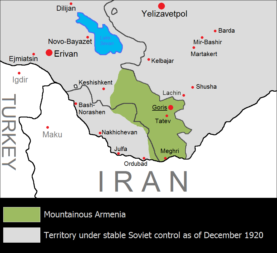
English: The Republic of Mountainous Armenia from December 1920 to June 1921. անհայտ |
| Թվական | |
| Աղբյուր | Բեռնողի սեփական աշխատանք |
| Հեղինակ | Yerevanci |
Արտոնագրում
Ես, սույն աշխատանքի հեղինակային իրավունքների տերը, այսուհետ այն հրատարակում եմ հետևյալ արտոնագրի ներքո։
Այս նիշքը հասանելի է Creative Commons Attribution-Share Alike 3.0 Unported արտոնագրի ներքո:
- Դուք ազատ եք՝
- կիսվել ստեղծագործությամբ – պատճենել, տարածել և փոխանցել այս աշխատանքը։
- վերափոխել – ադապտացնել աշխատանքը
- Պահպանելով հետևյալ պայմանները'
- հղում – Դուք պետք է նշեք հեղինակի (իրավատիրոջ) հղումը:
- համանման տարածում – Եթե դուք ձևափոխում եք, փոխակերպում, կամ այս աշխատանքի հիման վրա ստեղծում եք նոր աշխատանք, ապա ձեր ստեղծածը կարող է տարածվել միայն նույն կամ համարժեք թույլատրագրով։

|
This historical map image could be re-created using vector graphics as an SVG file. This has several advantages; see Commons:Media for cleanup for more information. If an SVG form of this image is available, please upload it and afterwards replace this template with
{{vector version available|new image name}}.
It is recommended to name the SVG file “Mountainous Armenia 1921.svg”—then the template Vector version available (or Vva) does not need the new image name parameter. |
Նիշքի պատմություն
Մատնահարեք օրվան/ժամին՝ նիշքի այդ պահին տեսքը դիտելու համար։
| Օր/Ժամ | Մանրապատկեր | Օբյեկտի չափը | Մասնակից | Մեկնաբանություն | |
|---|---|---|---|---|---|
| ընթացիկ | 11:56, 18 Օգոստոսի 2023 | | 934 × 853 (47 ԿԲ) | Golden | Reverted to version as of 21:15, 17 July 2023 (UTC) It did not match the borders of East Zangezur either. Lachin city was under the control of Azeri-soviet forces by the time of this map. This file has no source anyway, it should not be used in Wikipedia articles |
| 18:11, 16 Օգոստոսի 2023 |  | 934 × 853 (53 ԿԲ) | Kevo327 | Reverted to version as of 19:44, 17 July 2023 (UTC) I highly doubt the borders matched perfectly to the ones the Soviets drew | |
| 21:15, 17 Հուլիսի 2023 |  | 934 × 853 (47 ԿԲ) | Golden | Reverted to version as of 17:33, 17 July 2023 (UTC) The map itself has no source. Mountainous Armenia almost never controlled East Zangezur and was under Soviet control during this time (not Azeri, sorry for the confusion) | |
| 19:44, 17 Հուլիսի 2023 |  | 934 × 853 (53 ԿԲ) | Rototekaraka | Reverted to version as of 17:55, 15 July 2023 (UTC) No source was provided to the edit made by the user Golden in regards to "east Zangezur (modern Azerbaijan) was under Azeri control at this time". The Azerbaijan Democratic Republic had ceased to exist in april of 1920, nearly 8 months before the Mountainous Republic of Armenia was established making it impossible for the lands highlighted by the edit to be "under Azeri control at this time". | |
| 17:33, 17 Հուլիսի 2023 |  | 934 × 853 (47 ԿԲ) | Golden | Reverted to version as of 08:47, 17 July 2023 (UTC) vandalism | |
| 10:17, 17 Հուլիսի 2023 |  | 934 × 853 (53 ԿԲ) | Rototekaraka | Reverted to version as of 17:55, 15 July 2023 (UTC) | |
| 08:47, 17 Հուլիսի 2023 |  | 934 × 853 (47 ԿԲ) | Golden | Reverted to version as of 14:39, 1 November 2022 (UTC) rv vandalism | |
| 17:55, 15 Հուլիսի 2023 |  | 934 × 853 (53 ԿԲ) | Rototekaraka | Reverted to version as of 03:51, 3 February 2015 (UTC) | |
| 14:39, 1 Նոյեմբերի 2022 |  | 934 × 853 (47 ԿԲ) | Golden | east Zangezur (modern Azerbaijan) was under Azeri control at this time | |
| 03:51, 3 փետրվարի 2015 |  | 934 × 853 (53 ԿԲ) | Yerevantsi | tweak |
Նիշքի օգտագործում
Այս նիշքին օգտագործող էջեր չկան։
Նիշքի համընդհանուր օգտագործում
Հետևյալ այլ վիքիները օգտագործում են այս նիշքը՝
- Օգտագործումը az.wikipedia.org կայքում
- Օգտագործումը be-tarask.wikipedia.org կայքում
- Օգտագործումը de.wikipedia.org կայքում
- Օգտագործումը en.wikipedia.org կայքում
- Օգտագործումը eo.wikipedia.org կայքում
- Օգտագործումը eo.wikinews.org կայքում
- Օգտագործումը es.wikipedia.org կայքում
- Օգտագործումը fi.wikipedia.org կայքում
- Օգտագործումը fr.wikipedia.org կայքում
- Օգտագործումը id.wikipedia.org կայքում
- Օգտագործումը ja.wikipedia.org կայքում
- Օգտագործումը ka.wikipedia.org կայքում
- Օգտագործումը ko.wikipedia.org կայքում
- Օգտագործումը mt.wikipedia.org կայքում
- Օգտագործումը nl.wikipedia.org կայքում
- Օգտագործումը pl.wikipedia.org կայքում
- Օգտագործումը pt.wikipedia.org կայքում
- Օգտագործումը ru.wikipedia.org կայքում
- Օգտագործումը tr.wikipedia.org կայքում
- Օգտագործումը uk.wikipedia.org կայքում
- Օգտագործումը vi.wikipedia.org կայքում
- Օգտագործումը www.wikidata.org կայքում
- Օգտագործումը zh.wikipedia.org կայքում