
Պատկեր:EU Member states and Candidate countries map.svg

Size of this PNG preview of this SVG file: 701 × 599 պիքսել. Այլ թույլտվությաններ: 281 × 240 պիքսել | 561 × 480 պիքսել | 898 × 768 պիքսել | 1198 × 1024 պիքսել | 2395 × 2048 պիքսել | 1401 × 1198 պիքսել.
Սկզբնական նիշք (SVG-նիշք, անվանապես 1401 × 1198 փիքսել, նիշքի չափը՝ 860 ԿԲ)
Ամփոփում
| Նկարագրում |
Asturianu: Estaos miembros de la XE (más los países candidatos)
Català: Estats membres de la UE (més els països candidats)
Deutsch: Mitgliedstaaten der EU (+ Bewerberländer)
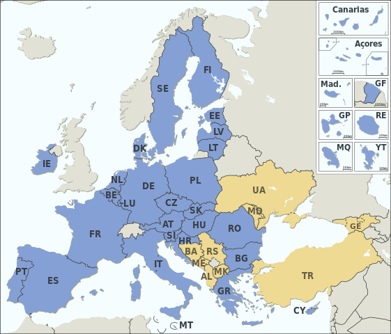
English: Member states of the EU (plus candidate countries)
Esperanto: Membraj ŝtatoj de EU (kaj kandidataj landoj)
Español: Estados miembros de la UE (más los países candidatos)
Français : Etats membres de l’UE (et pays candidats)
Italiano: Stati membri dell’UE (+ Paesi candidati)
Македонски: Земји членки на ЕУ (+ кандидати)
Member states of the EU Candidate countries
|
|||||||||||||||||||||||||||||||||||||||||||||||||||||||||||||||||||||||||||||||||||
| Թվական | ||||||||||||||||||||||||||||||||||||||||||||||||||||||||||||||||||||||||||||||||||||
| Աղբյուր |
Natural Earth 1:50m (http://www.naturalearthdata.com) This SVG _?_ includes elements from this _?_: |
|||||||||||||||||||||||||||||||||||||||||||||||||||||||||||||||||||||||||||||||||||
| Հեղինակ | Alexrk2 | |||||||||||||||||||||||||||||||||||||||||||||||||||||||||||||||||||||||||||||||||||
| Այլ մեկնակերպներ |
|
|||||||||||||||||||||||||||||||||||||||||||||||||||||||||||||||||||||||||||||||||||
| SVG genesis | Սա վեկտոր գրաֆիկական պատկեր է ստեղծված է եղել Batik օգնությամբ: . and with Inkscape.
|


Արտոնագրում
Ես, սույն աշխատանքի հեղինակային իրավունքների տերը, այսուհետ այն հրատարակում եմ հետևյալ արտոնագրի ներքո։
Այս նիշքը հասանելի է Creative Commons Attribution-Share Alike 3.0 Unported արտոնագրի ներքո:
- Դուք ազատ եք՝
- կիսվել ստեղծագործությամբ – պատճենել, տարածել և փոխանցել այս աշխատանքը։
- վերափոխել – ադապտացնել աշխատանքը
- Պահպանելով հետևյալ պայմանները'
- հղում – Դուք պետք է նշեք հեղինակի (իրավատիրոջ) հղումը:
- համանման տարածում – Եթե դուք ձևափոխում եք, փոխակերպում, կամ այս աշխատանքի հիման վրա ստեղծում եք նոր աշխատանք, ապա ձեր ստեղծածը կարող է տարածվել միայն նույն կամ համարժեք թույլատրագրով։
Նիշքի պատմություն
Մատնահարեք օրվան/ժամին՝ նիշքի այդ պահին տեսքը դիտելու համար։
| Օր/Ժամ | Մանրապատկեր | Օբյեկտի չափը | Մասնակից | Մեկնաբանություն | |
|---|---|---|---|---|---|
| ընթացիկ | 17:11, 31 հունվարի 2024 | | 1401 × 1198 (860 ԿԲ) | Janitoalevic | Armenia-Azerbaijan update |
| 00:27, 15 Դեկտեմբերի 2023 |  | 1401 × 1198 (860 ԿԲ) | Iktsokh | Georgia is recognized as an official candidate. | |
| 16:12, 6 փետրվարի 2023 |  | 1401 × 1198 (860 ԿԲ) | Nestrus | forgot the caption | |
| 16:07, 6 փետրվարի 2023 |  | 1401 × 1198 (859 ԿԲ) | Nestrus | +candidate Bosnia | |
| 18:58, 23 Հունիսի 2022 |  | 1401 × 1198 (845 ԿԲ) | Cyygma | Ukraine and Modova confirmed as official candidates | |
| 15:13, 1 փետրվարի 2020 |  | 1401 × 1198 (844 ԿԲ) | Hansbaer | absurd argument. The map has always followed the development of the EU | |
| 14:48, 1 փետրվարի 2020 |  | 1401 × 1198 (845 ԿԲ) | Alexis Jazz | Reverted to version as of 16:53, 17 March 2015 (UTC) User:Janitoalevic needs to be uploaded as a new file | |
| 23:15, 31 հունվարի 2020 |  | 1401 × 1198 (844 ԿԲ) | Janitoalevic | Brexit | |
| 16:53, 17 Մարտի 2015 |  | 1401 × 1198 (845 ԿԲ) | Appaches | Ukraine-Crimée : séparation pointillée | |
| 17:05, 15 Մարտի 2015 |  | 1401 × 1198 (844 ԿԲ) | Appaches | Islande retirée |
Նիշքի օգտագործում
Հետևյալ էջը հղվում է այս նիշքին՝
Նիշքի համընդհանուր օգտագործում
Հետևյալ այլ վիքիները օգտագործում են այս նիշքը՝
- Օգտագործումը ab.wikipedia.org կայքում
- Օգտագործումը ar.wikipedia.org կայքում
- Օգտագործումը ast.wikipedia.org կայքում
- Օգտագործումը az.wikipedia.org կայքում
- Օգտագործումը az.wiktionary.org կայքում
- Օգտագործումը be-tarask.wikipedia.org կայքում
- Օգտագործումը br.wikipedia.org կայքում
- Օգտագործումը ca.wikipedia.org կայքում
- Օգտագործումը cy.wikipedia.org կայքում
- Օգտագործումը da.wikipedia.org կայքում
- Օգտագործումը de.wikipedia.org կայքում
- Europäische Union
- Portal:Europäische Union
- Mitgliedstaaten der Europäischen Union
- Gebiet der Europäischen Union
- Vorlage:Imagemap Mitgliedstaaten der Europäischen Union
- Vorlage:Imagemap Mitgliedstaaten der Europäischen Union/Test
- Wikipedia:Kartenwerkstatt/Archiv/2011-04
- Benutzer:RickVulcan/Länder Europas
- Extrempunkte der Europäischen Union
- Benutzer:Kpfiwa/Spielwiese/Test
- Benutzer:Oesterreicher12/Spielwiese 2
- Benutzer:HudecEmil
- Օգտագործումը de.wiktionary.org կայքում
- Օգտագործումը ext.wikipedia.org կայքում
- Օգտագործումը fiu-vro.wikipedia.org կայքում
- Օգտագործումը fo.wikipedia.org կայքում
- Օգտագործումը frp.wikipedia.org կայքում
- Օգտագործումը fr.wikipedia.org կայքում
- Élargissement de l'Union européenne
- Droit européen
- Utilisateur:William Pedros
- Modèle:UE-EU-ISO 3166-1 530px
- Union européenne
- Futur élargissement de l'Union européenne
- Wikipédia:Atelier graphique/Cartes/Archives/mai 2014
- Wikipédia:Atelier graphique/Cartes/Archives/mars 2015
- Utilisateur:AlexisN
- Wikipédia:Atelier graphique/Cartes/Archives/août 2017
- Օգտագործումը fr.wikibooks.org կայքում
- Օգտագործումը fur.wikipedia.org կայքում
- Օգտագործումը fy.wikipedia.org կայքում
- Օգտագործումը gd.wikipedia.org կայքում
- Օգտագործումը he.wikipedia.org կայքում
- Օգտագործումը hr.wikipedia.org կայքում
- Օգտագործումը hu.wikipedia.org կայքում
- Օգտագործումը ia.wikipedia.org կայքում
- Օգտագործումը id.wikipedia.org կայքում
Տեսնել այս նիշքի ավելի համընդհանուր օգտագործումը: