
Պատկեր:DesertStormMap v2.svg

Size of this PNG preview of this SVG file: 800 × 563 պիքսել. Այլ թույլտվությաններ: 320 × 225 պիքսել | 640 × 451 պիքսել | 1024 × 721 պիքսել | 1280 × 901 պիքսել | 2560 × 1802 պիքսել | 1500 × 1056 պիքսել.
Սկզբնական նիշք (SVG-նիշք, անվանապես 1500 × 1056 փիքսել, նիշքի չափը՝ 3,13 ՄԲ)
|

Ամփոփում
Սա վեկտոր գրաֆիկական պատկեր է ստեղծված է եղել Inkscape օգնությամբ: .
| Անվանում |
Operation Desert Storm |
||||
| Description |
العربية: عملية عاصفة الصحراء، ضمن حرب الخليج الثانية، 24-28 شباط/ فبراير 1991.
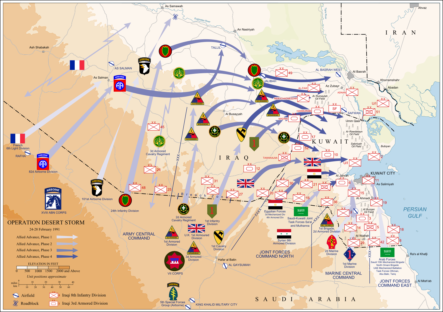
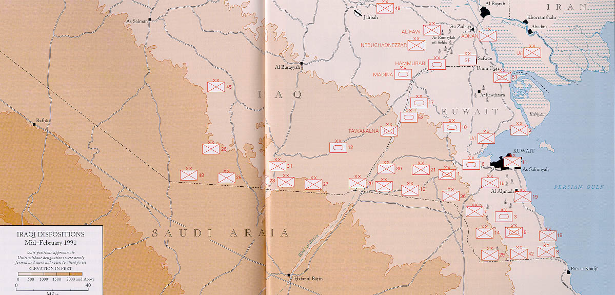
English: Map of ground operations of Operation Desert Storm starting invasion February 24-28th 1991. Shows allied and Iraqi forces. Special arrows indicate the American 101st Airborne division moved by air and where the French 6st light division and American 3rd Armored Cavalry Regiment provided security.
Français : Carte montrant les opérations terrestres menées lors de l'opération Tempête du désert entre le 24 et le 28 février 1991 : les positions tenues par les armées irakienne et alliées, et les mouvements de cette dernière. Des flèches particulières indiquent les manœuvres héliportées pratiquées par la 101e division aéroportée, ainsi que les zones sécurisées par la 6e brigade légère blindée française et par le 3e régiment blindé de cavalerie américain. |
||||
| Թվական | (UTC) | ||||
| Աղբյուր | self-vectored from Image:Operation Desert Storm.jpg from this site and this site. | ||||
| Ստեղծել է | |||||
| Geotemporal data | |||||
| Պատկերման ամսաթիվ | |||||
| Map location | Iraq/Kuwait border | ||||
| OpenStreetMap zoom level | 9 | ||||
| Bounding box |
|
||||
| Georeferencing | |||||
| Bibliographic data | |||||
| Լեզու | eng | ||||
| Archival data | |||||
| Տեխնիկա | Inkscape SVG | ||||
| Այլ մեկնակերպներ |
 |
||||

Արտոնագրում
This file is a work of a U.S. Army soldier or employee, taken or made as part of that person's official duties. As a work of the U.S. federal government, it is in the public domain in the United States.
|
 |
Ես, այս աշխատանքի հեղինակային իրավունքների տերը, ներկա հրատարակում եմ սրա հետևյալ լիցենզիաների պայմաններով

|
Այս վավերագրման պատճենահանման, տարածման և/կամ ձևափոխման թույլտվություն կամ լիցենզիայի GNU FDL պայմաններով 1.2 մեկնակերպի կամ ավելի ուշ, հրատարակված Ազատ ծրագրային ապահովության հիմնադրամում, առանց անփոփոխելի հատվածների, առանց բնագիրների, որոնք տեղադրված են առաջին և վերջին շապիկներում: Լիցենզիայի պատճենը գտնվում է GNU Free Documentation License հատվածում: |
This file is licensed under the Creative Commons Attribution-Share Alike Attribution-Share Alike 4.0 International, 3.0 Unported, 2.5 Generic, 2.0 Generic and 1.0 Generic license.
- Դուք ազատ եք՝
- կիսվել ստեղծագործությամբ – պատճենել, տարածել և փոխանցել այս աշխատանքը։
- վերափոխել – ադապտացնել աշխատանքը
- Պահպանելով հետևյալ պայմանները'
- հղում – Դուք պետք է նշեք հեղինակի (իրավատիրոջ) հղումը:
- համանման տարածում – Եթե դուք ձևափոխում եք, փոխակերպում, կամ այս աշխատանքի հիման վրա ստեղծում եք նոր աշխատանք, ապա ձեր ստեղծածը կարող է տարածվել միայն նույն կամ համարժեք թույլատրագրով։
Կարող եք ընտրել այս թույլատրագրերից ցանկացածը։
Նիշքի պատմություն
Մատնահարեք օրվան/ժամին՝ նիշքի այդ պահին տեսքը դիտելու համար։
| Օր/Ժամ | Մանրապատկեր | Օբյեկտի չափը | Մասնակից | Մեկնաբանություն | |
|---|---|---|---|---|---|
| ընթացիկ | 13:14, 9 Հունիսի 2012 | | 1500 × 1056 (3,13 ՄԲ) | Coolland | uploaded with x-external-editor |
| 04:31, 6 փետրվարի 2008 |  | 1500 × 1056 (3,13 ՄԲ) | Jeff Dahl | flags/label edits | |
| 21:00, 4 փետրվարի 2008 |  | 1500 × 1056 (2,89 ՄԲ) | Jeff Dahl | == Summary == {{Inkscape}} {{Information |Description=Map of ground operations of Operation Desert Storm from February 24-28th 1991. Shows allied and Iraqi forces. |Source=self-made, vectored from Image:Operation Desert Storm.jpg from [http://www.his |
Նիշքի օգտագործում
Հետևյալ էջը հղվում է այս նիշքին՝
Նիշքի համընդհանուր օգտագործում
Հետևյալ այլ վիքիները օգտագործում են այս նիշքը՝
- Օգտագործումը an.wikipedia.org կայքում
- Օգտագործումը ar.wikipedia.org կայքում
- Օգտագործումը bg.wikipedia.org կայքում
- Օգտագործումը br.wikipedia.org կայքում
- Օգտագործումը ca.wikipedia.org կայքում
- Օգտագործումը cs.wikipedia.org կայքում
- Օգտագործումը de.wikipedia.org կայքում
- Օգտագործումը el.wikipedia.org կայքում
- Օգտագործումը en.wikipedia.org կայքում
- French Foreign Legion
- Kuwait Armed Forces
- Armed Forces of Saudi Arabia
- 101st Airborne Division
- 82nd Airborne Division
- Gulf War
- 1st Cavalry Division (United States)
- 3rd Armored Division (United States)
- VII Corps (United States)
- 24th Infantry Division (United States)
- Norman Schwarzkopf Jr.
- 1st (United Kingdom) Division
- Air assault
- Battle of Khafji
- Royal Green Jackets (Rifles) Museum
- Iraqi invasion of Kuwait
- List of conflicts in Asia
- Opération Daguet
- Portal:Maps/Selected picture
- 1st Foreign Cavalry Regiment
- Wikipedia:WikiProject Iraq
- Wikipedia:Featured pictures thumbs/10
- Wikipedia:Featured picture candidates/February-2008
- Wikipedia:Featured picture candidates/Operation Desert Storm
- Wikipedia:Wikipedia Signpost/2008-02-18/Features and admins
- User talk:Jeff Dahl/Archive 3
- 82nd Sustainment Brigade
- Wikipedia:Featured pictures/Diagrams, drawings, and maps/Maps
- Wikipedia:WikiProject United States Government
- Wikipedia:Picture of the day/July 2008
- Template:POTD/2008-07-27
- User talk:Jeff Dahl/Archive 4
- Wikipedia:Wikipedia Signpost/2008-02-18/SPV
- Portal:Maps/Selected picture/38
- Wikipedia:WikiProject Military history/Showcase
- Wikipedia:WikiProject Military history/Showcase/FP
- 1st Brigade, 24th Infantry Division (United States)
Տեսնել այս նիշքի ավելի համընդհանուր օգտագործումը: