
Պատկեր:Corinth, Greece (NASA).jpg

Սկզբնական նիշք (2514 × 1686 փիքսել, նիշքի չափը՝ 7,43 ՄԲ, MIME-տեսակը՝ image/jpeg)
.jpg)
Ամփոփում
| Նկարագրում |
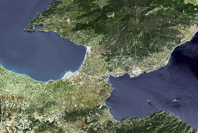
Español: Corinto y su istmo (Grecia). Foto satélite de la NASA.
English: The Isthmus of Corinth has played a very important role in the history of Greece. It is the only land bridge between the country's north (Attica) and south (Peloponnese). It is a 6 km wide tongue of land separating the Gulf of Corinth from the Saronic Sea. Populations, armies and commodities have got to move through it. In the 6th century BCE, the Greeks built the Diolkos, a 10 meter-wide stone roadway to pull ships across the Isthmus on wooden cylinders and wheeled vehicles. In 1882, a canal was started and completed 11 years later. It is 6343 meters long, 25 meters wide, and 8 meters deep.
With its 14 spectral bands from the visible to the thermal infrared wavelength region, and its high spatial resolution of 15 to 90 meters (about 50 to 300 feet), ASTER images Earth to map and monitor the changing surface of our planet. ASTER is one of five Earth-observing instruments launched December 18, 1999, on NASA's Terra satellite. The instrument was built by Japan's Ministry of Economy, Trade and Industry. A joint U.S./Japan science team is responsible for validation and calibration of the instrument and the data products. The broad spectral coverage and high spectral resolution of ASTER provides scientists in numerous disciplines with critical information for surface mapping, and monitoring of dynamic conditions and temporal change. Example applications are: monitoring glacial advances and retreats; monitoring potentially active volcanoes; identifying crop stress; determining cloud morphology and physical properties; wetlands evaluation; thermal pollution monitoring; coral reef degradation; surface temperature mapping of soils and geology; and measuring surface heat balance. The U.S. science team is located at NASA's Jet Propulsion Laboratory, Pasadena, Calif. The Terra mission is part of NASA's Science Mission Directorate.
|
| Թվական | |
| Աղբյուր | https://www.flickr.com/photos/pingnews/449549729/ (see also http://photojournal.jpl.nasa.gov/catalog/PIA01919) |
| Հեղինակ | NASA/GSFC/METI/ERSDAC/JAROS, and U.S./Japan ASTER Science Team |
| Այլ մեկնակերպներ | File:Corinth ast 2005129 lrg.jpg |
Այս պատկերը կամ տեսագրությունը մտցրած են одного из исследовательских центров Национального управления США по аэронавтике и исследованию космического пространства (NASA)под идентификатором (Photo ID): PIA01919. Эта пометка не указывает на правовой статус данной работы. Пометка о правовом статусе по-прежнему необходима. См. подробнее правила лицензирования Викисклада. Other languages:
|
Արտոնագրում
| Այս նիշքը հանրության սեփականության է պատկանում, քանզի այն ստեղծվել է ՆԱՍԱ-ն։ ՆԱՍԱ-ի հեղինակային իրավունքների մասին քաղաքականությունը նշում է, որ «ՆԱՍԱ-ի նյութերը հեղինակային իրավունքներով պաշտպանված չեն, միթե այդպես նշված լինի»։ (Տե՛ս Template:PD-USGov, ՆԱՍԱ-ի հեղինակային իրավունքների քաղաքականության մասին էջը կամ ՋեյՓիԷլի պատկերների օգտագործման մասին քաղաքականությունը)։ | ||
 |
Զգուշացումներ՝:
|
Նիշքի պատմություն
Մատնահարեք օրվան/ժամին՝ նիշքի այդ պահին տեսքը դիտելու համար։
| Օր/Ժամ | Մանրապատկեր | Օբյեկտի չափը | Մասնակից | Մեկնաբանություն | |
|---|---|---|---|---|---|
| ընթացիկ | 00:44, 12 Օգոստոսի 2008 | | 2514 × 1686 (7,43 ՄԲ) | FlickreviewR | Replacing image by its original image from Flickr |
| 17:22, 10 Հուլիսի 2007 |  | 1024 × 687 (629 ԿԲ) | Dorieo21 | {{Information |Description=Corinto y su istmo (Grecia). Foto sarélite de la NASA. |Source=http://www.flickr.com/photos/pingnews/449549729/ |Date=7 abril 2007 |Author=pingnews.com pingnews.com |Permission= |other_versions= }} |
Նիշքի օգտագործում
Այս նիշքին օգտագործող էջեր չկան։
Նիշքի համընդհանուր օգտագործում
Հետևյալ այլ վիքիները օգտագործում են այս նիշքը՝
- Օգտագործումը arz.wikipedia.org կայքում
- Օգտագործումը ceb.wikipedia.org կայքում
- Օգտագործումը cs.wikipedia.org կայքում
- Օգտագործումը eo.wikipedia.org կայքում
- Օգտագործումը es.wikipedia.org կայքում
- Օգտագործումը fi.wikipedia.org կայքում
- Օգտագործումը fr.wikipedia.org կայքում
- Օգտագործումը hu.wikipedia.org կայքում
- Օգտագործումը it.wikipedia.org կայքում
- Օգտագործումը ja.wikipedia.org կայքում
- Օգտագործումը ka.wikipedia.org կայքում
- Օգտագործումը ko.wikipedia.org կայքում
- Օգտագործումը pl.wikipedia.org կայքում
- Օգտագործումը ro.wikipedia.org կայքում
- Օգտագործումը ru.wikipedia.org կայքում
- Օգտագործումը sv.wikipedia.org կայքում
- Օգտագործումը sw.wikipedia.org կայքում
- Օգտագործումը vls.wikipedia.org կայքում
- Օգտագործումը www.wikidata.org կայքում
.jpg)