
Պատկեր:Civitas Londinium or The Agas Map of London.jpg

Նախադիտման չափ՝ 800 × 338 պիքսել։ Այլ թույլտվությաններ: 320 × 135 պիքսել | 640 × 271 պիքսել | 1024 × 433 պիքսել | 1280 × 541 պիքսել | 4730 × 2000 պիքսել.
Սկզբնական նիշք (4730 × 2000 փիքսել, նիշքի չափը՝ 4,08 ՄԲ, MIME-տեսակը՝ image/jpeg)
Ամփոփում
| Նկարագրում |
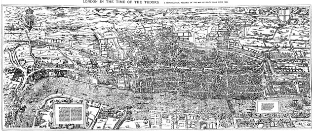
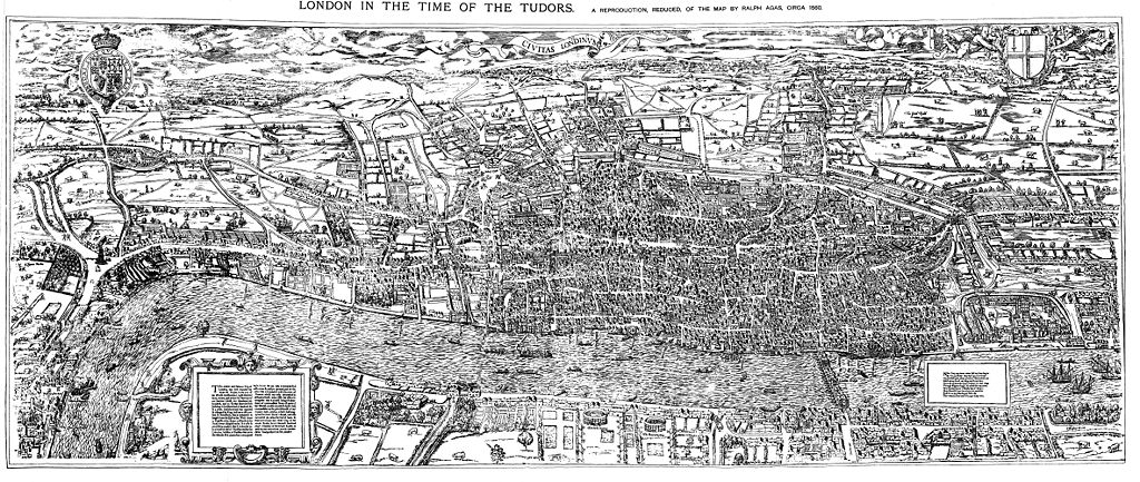
English: The earliest proper map (as opposed to panorama) of London known. Attributed to Ralph Agas, and probably surveyed between 1570 and 1605. The original was 6 foot 0.5 inches long by 2 feet 4.5 inches wide. This much reduced image is a scan of a copy of a lithograph of a copy, was itself badly repaired with sellotape and has had to be "restored"; so is hardly a truly faithful representation of the original, but few good copies exist and no other detailed public domain images are known. |
| Թվական | |
| Աղբյուր | Maps of Old London, London, Adam and Charles Black, 1908. Scanned & corrected Mike Calder. |
| Հեղինակ | Mike Calder, image of Civitas Londinium, Agas' Map of London, c. 1570-1605 |
| Այլ մեկնակերպներ | Derivative works of this file: Covent Garden from the Ralph Agas 1572 map of London.jpg |
Արտոնագրում
|
This work is in the public domain in its country of origin and other countries and areas where the copyright term is the author's life plus 100 years or fewer. | |
| This file has been identified as being free of known restrictions under copyright law, including all related and neighboring rights. | |
Նիշքի պատմություն
Մատնահարեք օրվան/ժամին՝ նիշքի այդ պահին տեսքը դիտելու համար։
| Օր/Ժամ | Մանրապատկեր | Օբյեկտի չափը | Մասնակից | Մեկնաբանություն | |
|---|---|---|---|---|---|
| ընթացիկ | 18:59, 14 Օգոստոսի 2009 | | 4730 × 2000 (4,08 ՄԲ) | MikeCalder | {{Information |Description={{en|1=The earliest proper map (as opposed to panorama) of London known. Attributed to Ralph Agas, and probably surveyed between 1570 and 1605. The original was 6 foot 0.5 inches long by 2 feet 4.5 inches wide. This much reduc |
Նիշքի օգտագործում
Հետևյալ էջը հղվում է այս նիշքին՝
Նիշքի համընդհանուր օգտագործում
Հետևյալ այլ վիքիները օգտագործում են այս նիշքը՝
- Օգտագործումը af.wikipedia.org կայքում
- Օգտագործումը ar.wikipedia.org կայքում
- Օգտագործումը avk.wikipedia.org կայքում
- Օգտագործումը azb.wikipedia.org կայքում
- Օգտագործումը de.wikipedia.org կայքում
- Օգտագործումը el.wikipedia.org կայքում
- Օգտագործումը en.wikipedia.org կայքում
- Օգտագործումը es.wikipedia.org կայքում
- Օգտագործումը fa.wikipedia.org կայքում
- Օգտագործումը it.wikipedia.org կայքում
- Օգտագործումը ja.wikipedia.org կայքում
- Օգտագործումը ko.wikipedia.org կայքում
- Օգտագործումը la.wikipedia.org կայքում
- Օգտագործումը pt.wikipedia.org կայքում
- Օգտագործումը ro.wikipedia.org կայքում
- Օգտագործումը ru.wikipedia.org կայքում
- Օգտագործումը simple.wikipedia.org կայքում
- Օգտագործումը sl.wikipedia.org կայքում
- Օգտագործումը tr.wikipedia.org կայքում
- Օգտագործումը uk.wikipedia.org կայքում
- Օգտագործումը zh.wikipedia.org կայքում