
Պատկեր:AustriaHungaryWWI.gif
Նախադիտման չափ՝ 681 × 599 պիքսել։ Այլ թույլտվությաններ: 273 × 240 պիքսել | 545 × 480 պիքսել | 776 × 683 պիքսել.
Սկզբնական նիշք (776 × 683 փիքսել, նիշքի չափը՝ 98 ԿԲ, MIME-տեսակը՝ image/gif)
Ամփոփում
| Նկարագրում |
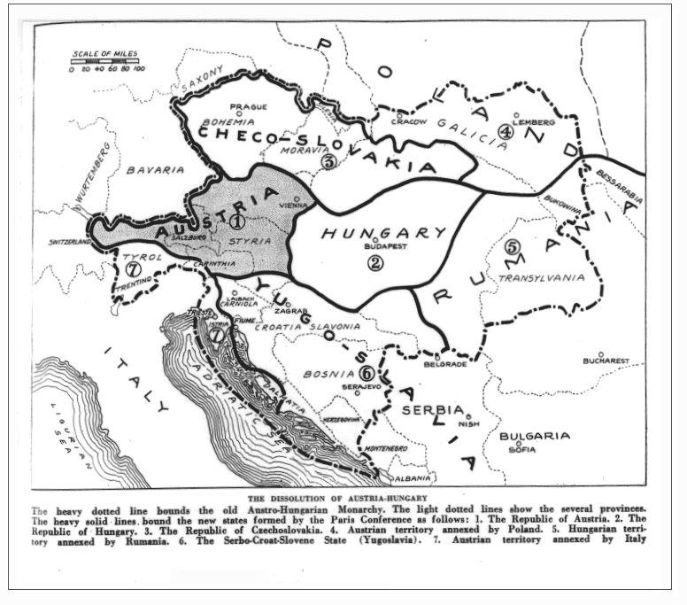
English: Drafted borders of Austria-Hungary in the Treaty of Trianon and Saint Germain. (map as published in the magazine; may differ from the later implementation of the treaty) |
| Թվական | |
| Աղբյուր |
https://babel.hathitrust.org/cgi/pt?id=iau.31858029095456;view=1up;seq=427 (Jump to 391) The Independent (New York), June 14, vol. 98, 1919, p. 391 (Primary source, if any, not cited) |
| Հեղինակ | The Independent |
Original upload log
The original description page was here. All following user names refer to en.wikipedia.
- 2009-01-20 00:44 Bizso 776×683 (100493 bytes)
Արտոնագրում
| Այս նիշքը հասանելի է Creative Commons Attribution-Share Alike 3.0 Unported արտոնագրի ներքո: Subject to disclaimers. | ||
| ||
| Այս արտոնգրության հատկանիշը ավելացված է տվյալ նիշքին որպես GFDL արտոնագրի բարեփոխում: |

|
Այս վավերագրման պատճենահանման, տարածման և/կամ ձևափոխման թույլտվություն կամ լիցենզիայի GNU FDL պայմաններով 1.2 մեկնակերպի կամ ավելի ուշ, հրատարակված Ազատ ծրագրային ապահովության հիմնադրամում, առանց անփոփոխելի հատվածների, առանց բնագիրների, որոնք տեղադրված են առաջին և վերջին շապիկներում: Լիցենզիայի պատճենը գտնվում է GNU Free Documentation License հատվածում: Subject to disclaimers. |
or
This media file is in the public domain in the United States. This applies to U.S. works where the copyright has expired, often because its first publication occurred prior to January 1, 1929, and if not then due to lack of notice or renewal. See this page for further explanation.
|
 | |
 |
This image might not be in the public domain outside of the United States; this especially applies in the countries and areas that do not apply the rule of the shorter term for US works, such as Canada, Mainland China (not Hong Kong or Macao), Germany, Mexico, and Switzerland. The creator and year of publication are essential information and must be provided. See Wikipedia:Public domain and Wikipedia:Copyrights for more details.
|
Նիշքի պատմություն
Մատնահարեք օրվան/ժամին՝ նիշքի այդ պահին տեսքը դիտելու համար։
| Օր/Ժամ | Մանրապատկեր | Օբյեկտի չափը | Մասնակից | Մեկնաբանություն | |
|---|---|---|---|---|---|
| ընթացիկ | 05:39, 26 հունվարի 2022 | | 776 × 683 (98 ԿԲ) | GPinkerton | Reverted to version as of 22:53, 20 January 2009 (UTC) COM:CROP, manipulation of historical images |
| 11:11, 27 Դեկտեմբերի 2021 |  | 762 × 642 (97 ԿԲ) | Claude Zygiel | Sub-Carpathian Ruthenia never was Polish, this is not a "historical map" but an error of a newspaper: correcting it is not "manipulation". | |
| 04:31, 27 Սեպտեմբերի 2021 |  | 776 × 683 (98 ԿԲ) | GPinkerton | Reverted to version as of 22:53, 20 January 2009 (UTC) COM:CROP, manipulation of historical images | |
| 09:27, 23 Հուլիսի 2020 |  | 762 × 642 (97 ԿԲ) | Claude Zygiel | Better (see [https://commons.wikimedia.org/wiki/File:Dissolution_of_Austria-Hungary.png]) | |
| 22:53, 20 հունվարի 2009 |  | 776 × 683 (98 ԿԲ) | Bizso | {{Information |Description={{en|New hand-drawn borders of Austria-Hungary in the Treaty of Trianon and Saint Germain.}} |Source=Transferred from [http://en.wikipedia.org en.wikipedia]; transfer was stated to be made by User:Bizso.<br/> (Original text |
Նիշքի օգտագործում
Հետևյալ էջը հղվում է այս նիշքին՝
Նիշքի համընդհանուր օգտագործում
Հետևյալ այլ վիքիները օգտագործում են այս նիշքը՝
- Օգտագործումը azb.wikipedia.org կայքում
- Օգտագործումը bg.wikipedia.org կայքում
- Օգտագործումը ca.wikipedia.org կայքում
- Օգտագործումը cy.wikipedia.org կայքում
- Օգտագործումը el.wikipedia.org կայքում
- Օգտագործումը en.wikipedia.org կայքում
- Օգտագործումը ga.wikipedia.org կայքում
- Օգտագործումը gl.wikipedia.org կայքում
- Օգտագործումը he.wikipedia.org կայքում
- Օգտագործումը hr.wikipedia.org կայքում
- Օգտագործումը id.wikipedia.org կայքում
- Օգտագործումը it.wikipedia.org կայքում
- Օգտագործումը ko.wikipedia.org կայքում
- Օգտագործումը lv.wikipedia.org կայքում
- Օգտագործումը pnb.wikipedia.org կայքում
- Օգտագործումը pt.wikipedia.org կայքում
- Օգտագործումը ru.wikipedia.org կայքում
- Օգտագործումը sh.wikipedia.org կայքում
- Օգտագործումը simple.wikipedia.org կայքում
- Օգտագործումը sk.wikipedia.org կայքում
- Օգտագործումը th.wikipedia.org կայքում
- Օգտագործումը ur.wikipedia.org կայքում
- Օգտագործումը vi.wikipedia.org կայքում
- Օգտագործումը zh.wikipedia.org կայքում