
Պատկեր:Afghanistan region during 500 BC.jpg
Afghanistan_region_during_500_BC.jpg (348 × 347 փիքսել, նիշքի չափը՝ 56 ԿԲ, MIME-տեսակը՝ image/jpeg)
| Նկարագրում |
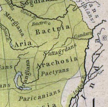
Español: Mapa histórico del Imperio Aqueménida.
English: Historic map of the Achaemenid Empire
Français : Carte historique de l'empire achéménide
Arachosia, Aria and Bactria were the ancient satraps of the Persian Achaemenid Empire that made up most of what is now Afghanistan and western Pakistan during 500 B.C. The main inhabitants of Arachosia were known as Pactyans, whose name possibly survives in today's Pakhtuns. |
||||
| Թվական | |||||
| Աղբյուր |
http://www.lib.utexas.edu/maps/historical/history_asia.html http://www.lib.utexas.edu/maps/historical/shepherd/persian_empire.jpg |
||||
| Հեղինակ | William R. Shepherd (b. 1871 - d. 1934) | ||||
| Իրավունքներ (Նիշքի վերաօգտագործումը) |
|
||||
| Այլ մեկնակերպներ | File:Map of the Achaemenid Empire.jpg (full) | ||||
Նիշքի պատմություն
Մատնահարեք օրվան/ժամին՝ նիշքի այդ պահին տեսքը դիտելու համար։
| Օր/Ժամ | Մանրապատկեր | Օբյեկտի չափը | Մասնակից | Մեկնաբանություն | |
|---|---|---|---|---|---|
| ընթացիկ | 13:48, 12 Մարտի 2010 | | 348 × 347 (56 ԿԲ) | Officer | {{Information |Description={{es|Mapa histórico del imperio Aqueménido.}} {{en|Historic map of the Achaemenid Empire}} {{fr|Carte historique de l'empire achéménide}} |Source=http://www.lib.utexas.edu/maps/historical/history_asia.html http://www.lib.ut |
| 20:47, 21 հունվարի 2010 |  | 324 × 357 (63 ԿԲ) | Officer | {{Information |Description={{es|Mapa histórico del imperio Aqueménido.}} {{en|Historic map of the Achaemenid Empire}} {{fr|Carte historique de l'empire achéménide}} |Source=http://www.lib.utexas.edu/maps/historical/history_asia.html http://www.lib.ut |
Նիշքի օգտագործում
Հետևյալ էջը հղվում է այս նիշքին՝
Նիշքի համընդհանուր օգտագործում
Հետևյալ այլ վիքիները օգտագործում են այս նիշքը՝
- Օգտագործումը am.wikipedia.org կայքում
- Օգտագործումը ar.wikipedia.org կայքում
- Օգտագործումը azb.wikipedia.org կայքում
- Օգտագործումը az.wikipedia.org կայքում
- Օգտագործումը bg.wikipedia.org կայքում
- Օգտագործումը bn.wikipedia.org կայքում
- Օգտագործումը ca.wikipedia.org կայքում
- Օգտագործումը de.wikipedia.org կայքում
- Օգտագործումը en.wikipedia.org կայքում
- Օգտագործումը eo.wikipedia.org կայքում
- Օգտագործումը es.wikipedia.org կայքում
- Օգտագործումը he.wikipedia.org կայքում
- Օգտագործումը hi.wikipedia.org կայքում
- Օգտագործումը hr.wikipedia.org կայքում
- Օգտագործումը id.wikipedia.org կայքում
- Օգտագործումը it.wikipedia.org կայքում
- Օգտագործումը ja.wikipedia.org կայքում
- Օգտագործումը ka.wikipedia.org կայքում
- Օգտագործումը lt.wikipedia.org կայքում
- Օգտագործումը mn.wikipedia.org կայքում
- Օգտագործումը pt.wikipedia.org կայքում
- Օգտագործումը ro.wikipedia.org կայքում
- Օգտագործումը ru.wikipedia.org կայքում
- Օգտագործումը sh.wikipedia.org կայքում
- Օգտագործումը sk.wikipedia.org կայքում
- Օգտագործումը sr.wikipedia.org կայքում
- Օգտագործումը ta.wikipedia.org կայքում
- Օգտագործումը tg.wikipedia.org կայքում
- Օգտագործումը uk.wikipedia.org կայքում
Տեսնել այս նիշքի ավելի համընդհանուր օգտագործումը: