Պատկեր:60m artificial fumarole at el tatio geothermal field.jpg
Սկզբնական նիշք (900 × 595 փիքսել, նիշքի չափը՝ 294 ԿԲ, MIME-տեսակը՝ image/jpeg)
Այս նիշքը տեղադրված է Վիքիպահեստում է և այն կարող է օգտագործվել այլ նախագծերի կողմից։ Վիքիպահեստում նիշքի մասին տեղեկությունների հիմնական մասը ներկայացված է ստորև։
Ամփոփում
Նկարագրում60m artificial fumarole at el tatio geothermal field.jpg |
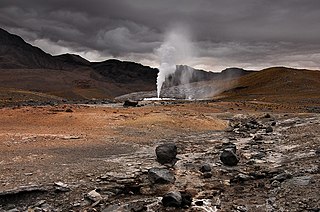
English: In 2008, the “Geortérmica del Norte” consortium - formed by Chilean state owned ENAP and Codelco mining companies in association with Italian Enel Green Power - began exploration in the "quebrada El Zoquete", near the El Tatio geothermal field in Chile's II Region, with the purpose of constructing a 40 MW geothermal plant. After months of exploration, an operating malfunction occurred in well No. 10 in September 2009, causing the eruption of a 60-m-high artificial fumarole which took away virtually all the pressure in the El Tatio complex. Although the company finally managed to close the well, damage was not limited to the visual. Ignorance of both guides and visitors - who were literally running all over the vents - caused extensive damage to the fragile mineral deposits, and the harm make take years, if not decades, to get undone. In fact, an earlier exploration attempt in the late sixties turned into disaster – even if only economically. |
Թվական | |
Աղբյուր | Բեռնողի սեփական աշխատանք |
Հեղինակ | Gerard Prins |
Տեսախցիկի տեղագրություն | 22° 21′ 00,6″ Հվ. լ., 68° 00′ 29,4″ Ամ. ե. | Այս և ուրիշ պատկերներ իրենց տեղագրությամբ OpenStreetMap | -22.350167; -68.008167 |
---|
Altitude: 4334.00 m
Արտոնագրում
- Դուք ազատ եք՝
- կիսվել ստեղծագործությամբ – պատճենել, տարածել և փոխանցել այս աշխատանքը։
- վերափոխել – ադապտացնել աշխատանքը
- Պահպանելով հետևյալ պայմանները'
- հղում – Դուք պետք է նշեք հեղինակի (իրավատիրոջ) հղումը:
- համանման տարածում – Եթե դուք ձևափոխում եք, փոխակերպում, կամ այս աշխատանքի հիման վրա ստեղծում եք նոր աշխատանք, ապա ձեր ստեղծածը կարող է տարածվել միայն նույն կամ համարժեք թույլատրագրով։
Այս վավերագրման պատճենահանման, տարածման և/կամ ձևափոխման թույլտվություն կամ լիցենզիայի GNU FDL պայմաններով 1.2 մեկնակերպի կամ ավելի ուշ, հրատարակված Ազատ ծրագրային ապահովության հիմնադրամում, առանց անփոփոխելի հատվածների, առանց բնագիրների, որոնք տեղադրված են առաջին և վերջին շապիկներում: Լիցենզիայի պատճենը գտնվում է GNU Free Documentation License հատվածում:http://www.gnu.org/copyleft/fdl.htmlGFDLGNU Free Documentation Licensetruetrue |
Items portrayed in this file
պատկերված
27 Սեպտեմբերի 2009
captured with անգլերեն
Nikon D200 անգլերեն
22°21'0.601"S, 68°0'29.401"W
image/jpeg
checksum անգլերեն
ec76e5e9568b40db414d1139663359b701eedd0c
data size անգլերեն
300 630 Բայթ
595 փիքսել
900 փիքսել
Նիշքի պատմություն
Մատնահարեք օրվան/ժամին՝ նիշքի այդ պահին տեսքը դիտելու համար։
Օր/Ժամ | Մանրապատկեր | Օբյեկտի չափը | Մասնակից | Մեկնաբանություն | |
---|---|---|---|---|---|
ընթացիկ | 07:47, 23 փետրվարի 2010 | 900 × 595 (294 ԿԲ) | Gerard Prins | {{Information |Description={{en|1=A failed prospecting drill for geothermal exploitation by the “Geortérmica del Norte” consortium, formed by Chilean state owned ENAP and Codelco in association with Italian state owned ENEL, has caused an eco disaste |
Նիշքի օգտագործում
Հետևյալ էջը հղվում է այս նիշքին՝
Նիշքի համընդհանուր օգտագործում
Հետևյալ այլ վիքիները օգտագործում են այս նիշքը՝
- Օգտագործումը ba.wikipedia.org կայքում
- Օգտագործումը en.wikipedia.org կայքում
- Օգտագործումը en.wikivoyage.org կայքում
- Օգտագործումը es.wikipedia.org կայքում
- Օգտագործումը id.wikipedia.org կայքում
- Օգտագործումը kk.wikipedia.org կայքում
- Օգտագործումը ru.wikipedia.org կայքում
- Օգտագործումը uk.wikipedia.org կայքում
Մետատվյալներ
Նիշքը պարունակում է ընդարձակ տվյալները, հավանաբար ավելացված թվային լուսանկարչական ապարատի կամ սկաների կողմից, որոնք օգտագործվել են նկարը ստեղծելու կամ թվայնացնելու համար։
Եթե նիշքը ձևափոխվել է ստեղծումից ի վեր, ապա որոշ տվյալները կարող են չհամապատասխանել ձևափոխված նիշքին։
Camera manufacturer | NIKON CORPORATION |
---|---|
Camera model | NIKON D200 |
Author | Gerard Prins |
Exposure time | 1/640 sec (0,0015625) |
F Number | f/10 |
ISO speed rating | 400 |
Date and time of data generation | 08:09, 27 Սեպտեմբերի 2009 |
Lens focal length | 16 mm |
User comments | (c) gerardprins.com (562) 758 7209 |
Latitude | 22° 21′ 0,6″ S |
Longitude | 68° 0′ 29,4″ W |
Altitude | 4334 meters above sea level |
Online copyright statement | http://www.gerardprins.com |
Copyright holder |
|
Image title |
|
Usage terms |
|
City shown | San Pedro de Atacama |
Width | 3872 փիքսել |
Height | 2592 փիքսել |
Bits per component |
|
Compression scheme | Uncompressed |
Pixel composition | RGB |
Orientation | Normal |
Number of components | 3 |
Horizontal resolution | 72 dpi |
Vertical resolution | 72 dpi |
Data arrangement | chunky format |
Software used | Adobe Photoshop CS3 Windows |
File change date and time | 04:42, 23 փետրվարի 2010 |
Pair of black and white reference values |
|
Exposure Program | Aperture priority |
Exif version | 2.2 |
Date and time of digitizing | 08:09, 27 Սեպտեմբերի 2009 |
APEX exposure bias | 0 |
Maximum land aperture | 4 APEX (f/4) |
Metering mode | Pattern |
Light source | Unknown |
Flash | Flash did not fire |
DateTime subseconds | 00 |
DateTimeOriginal subseconds | 00 |
DateTimeDigitized subseconds | 00 |
Supported Flashpix version | 1 |
Color space | sRGB |
Sensing method | One-chip color area sensor |
File source | Digital still camera |
Scene type | A directly photographed image |
Custom image processing | Normal process |
Exposure mode | Auto exposure |
White balance | Auto white balance |
Digital zoom ratio | 1 |
Focal length in 35 mm film | 24 mm |
Scene capture type | Standard |
Scene control | Low gain up |
Contrast | Normal |
Saturation | Normal |
Sharpness | Hard |
Subject distance range | Unknown |
GPS time (atomic clock) | 12:09 |
Satellites used for measurement | 09 |
GPS tag version | 0.0.2.2 |
Supported Flashpix version | 1 |
GPS date | 08:09, 27 Սեպտեմբերի 2009 |
Geodetic survey data used | |
Image width | 900 փիքսել |
Image height | 595 փիքսել |
Date metadata was last modified | 01:42, 23 փետրվարի 2010 |
Copyright status | Copyrighted |
Contact information | gerard@gerardprins.com
www.gerardprins.com Parque Villarrica 9094, Peñalolén Santiago, R.M., 794-0933 Chile |
Province or state shown | II Region |
Country shown | Chile |
Sublocation of city shown | Hoyada de los Géiseres del Tatio |
Code for country shown | CL |
IIM version | 2 |