
Պատկեր:Yemen division 2011-10-23.svg

Size of this PNG preview of this SVG file: 800 × 522 պիքսել. Այլ թույլտվությաններ: 320 × 209 պիքսել | 640 × 418 պիքսել | 1024 × 669 պիքսել | 1280 × 836 պիքսել | 2560 × 1671 պիքսել | 1524 × 995 պիքսել.
Սկզբնական նիշք (SVG-նիշք, անվանապես 1524 × 995 փիքսել, նիշքի չափը՝ 1,07 ՄԲ)
Ամփոփում
| Նկարագրում |
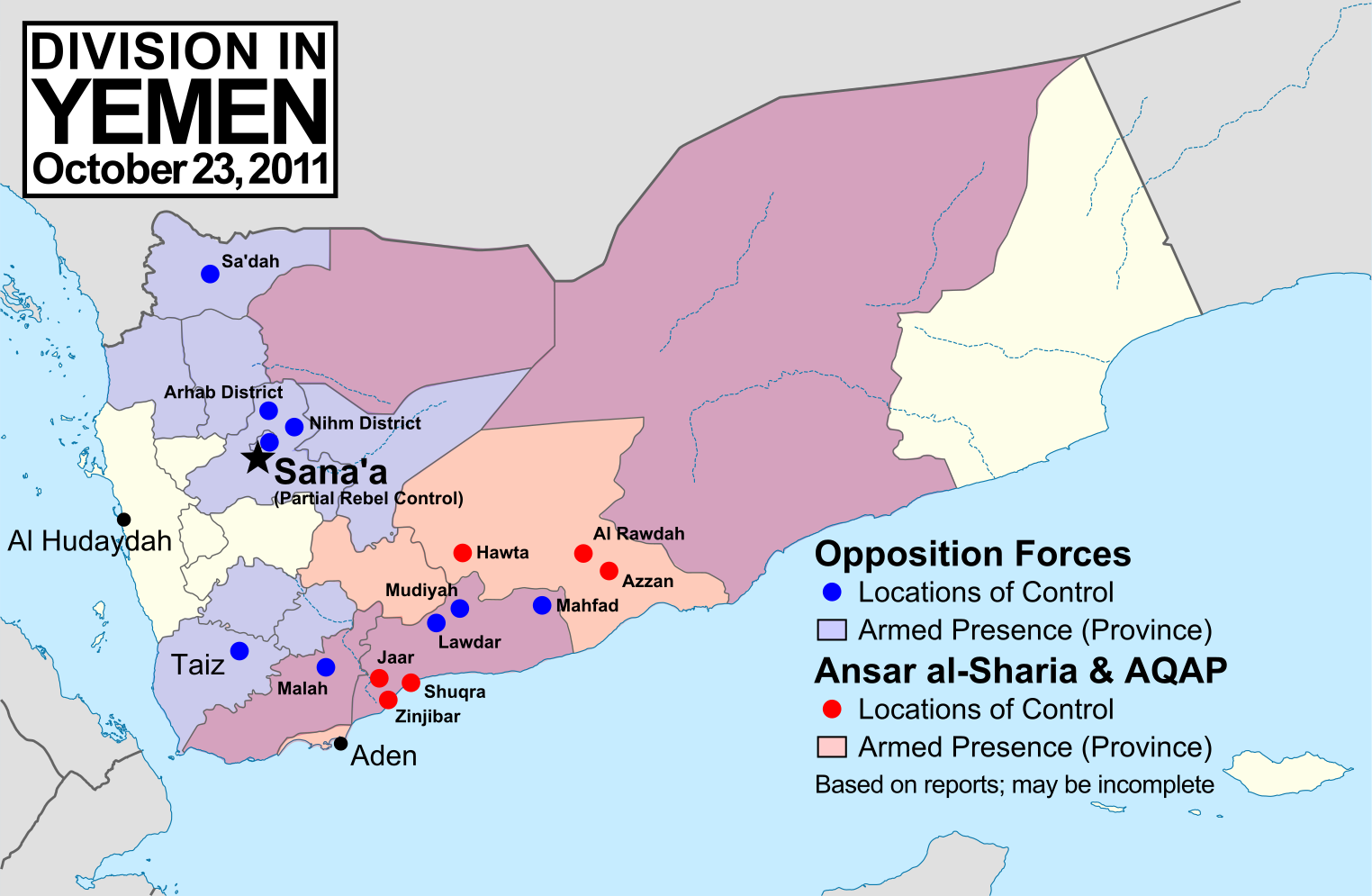
English: Note: This map depicts the situation in October 2011. For an updated version, see File:Yemen division 2012-3-11.svg. Map of division in Yemen as of October 23, 2011. Map is limited to information from English-language media, and therefore may be incomplete. Red represents Islamist extremists under Ansar al-Sharia and/or Al-Qaeda in the Arabian Peninsula (AQAP). Blue represents all other non-government armed groups which are hostile or possibly hostile to the government of President Ali Abdullah Saleh, including military defectors, pre-existing rebel groups, and local and kinship-based militias (including those which have worked together with the government against Ansar al-Sharia). Dots indicate specific locations cited by the media as being currently controlled by said groups, while shading indicates provinces (governorates) from which an open armed presence or attacks by said groups have been reported since the uprising began. Purple shading indicates that Ansar al-Sharia/AQAP and other non-government forces both have armed presences reported within the province, while white indicates that no rebel activity has been reported (implying that Saleh's government still fully maintains state power there). Note that unarmed protests are not depicted, and would extend well into the white areas of the map. See also: File:Yemen division 2011-7-7.svg |
| Թվական | |
| Աղբյուր | Բեռնողի սեփական աշխատանք, starting from File:Yemen_location_map.svg by user NordNordWest. Information comes from a variety of online news sources, especially the Yemen Post and Critical Threats. |
| Հեղինակ | GeoEvan |
| Իրավունքներ (Նիշքի վերաօգտագործումը) |
Modified version of file from Political Geography Now blog, re-licensed here to allow for commercial use. Please credit "Political Geography Now" with link to http://www.polgeonow.com. |
Արտոնագրում
Ես, սույն աշխատանքի հեղինակային իրավունքների տերը, այսուհետ այն հրատարակում եմ հետևյալ արտոնագրի ներքո։
Այս նիշքը հասանելի է Creative Commons Attribution-Share Alike 3.0 Unported արտոնագրի ներքո:
- Դուք ազատ եք՝
- կիսվել ստեղծագործությամբ – պատճենել, տարածել և փոխանցել այս աշխատանքը։
- վերափոխել – ադապտացնել աշխատանքը
- Պահպանելով հետևյալ պայմանները'
- հղում – Դուք պետք է նշեք հեղինակի (իրավատիրոջ) հղումը:
- համանման տարածում – Եթե դուք ձևափոխում եք, փոխակերպում, կամ այս աշխատանքի հիման վրա ստեղծում եք նոր աշխատանք, ապա ձեր ստեղծածը կարող է տարածվել միայն նույն կամ համարժեք թույլատրագրով։
Նիշքի պատմություն
Մատնահարեք օրվան/ժամին՝ նիշքի այդ պահին տեսքը դիտելու համար։
| Օր/Ժամ | Մանրապատկեր | Օբյեկտի չափը | Մասնակից | Մեկնաբանություն | |
|---|---|---|---|---|---|
| ընթացիկ | 15:15, 19 Նոյեմբերի 2011 | | 1524 × 995 (1,07 ՄԲ) | GeoEvan | Corrections per English Wikipedia talk page (http://en.wikipedia.org/wiki/File_talk:Yemen_division_2011-10-23.svg): Added Sa'dah city to opposition controlled locations; changed "Islamist Militants" label to "Ansar a-Sharia & AQAP" so as to exclude the un |
| 19:41, 25 Հոկտեմբերի 2011 |  | 1524 × 995 (1,04 ՄԲ) | GeoEvan | =={{int:filedesc}}== {{Information |description={{en|1=Map of division in Yemen as of October 23, 2011. Map is limited to information from from English-language media, and therefore may be incomplete. Red represents Islamist militants (Ansar al-Sharia and |
Նիշքի օգտագործում
Հետևյալ էջը հղվում է այս նիշքին՝
Նիշքի համընդհանուր օգտագործում
Հետևյալ այլ վիքիները օգտագործում են այս նիշքը՝
- Օգտագործումը azb.wikipedia.org կայքում
- Օգտագործումը ca.wikipedia.org կայքում
- Օգտագործումը en.wikipedia.org կայքում
- Օգտագործումը it.wikipedia.org կայքում
- Օգտագործումը ka.wikipedia.org կայքում
- Օգտագործումը pl.wikipedia.org կայքում
- Օգտագործումը pt.wikipedia.org կայքում
- Օգտագործումը ru.wikipedia.org կայքում
- Օգտագործումը www.wikidata.org կայքում