
Պատկեր:Wallace-line1.jpg
Նախադիտման չափ՝ 800 × 503 պիքսել։ Այլ թույլտվությաններ: 320 × 201 պիքսել | 640 × 403 պիքսել | 1024 × 644 պիքսել | 1280 × 805 պիքսել | 2560 × 1610 պիքսել | 3685 × 2318 պիքսել.
Սկզբնական նիշք (3685 × 2318 փիքսել, նիշքի չափը՝ 3,6 ՄԲ, MIME-տեսակը՝ image/jpeg)
Ամփոփում
| Description |
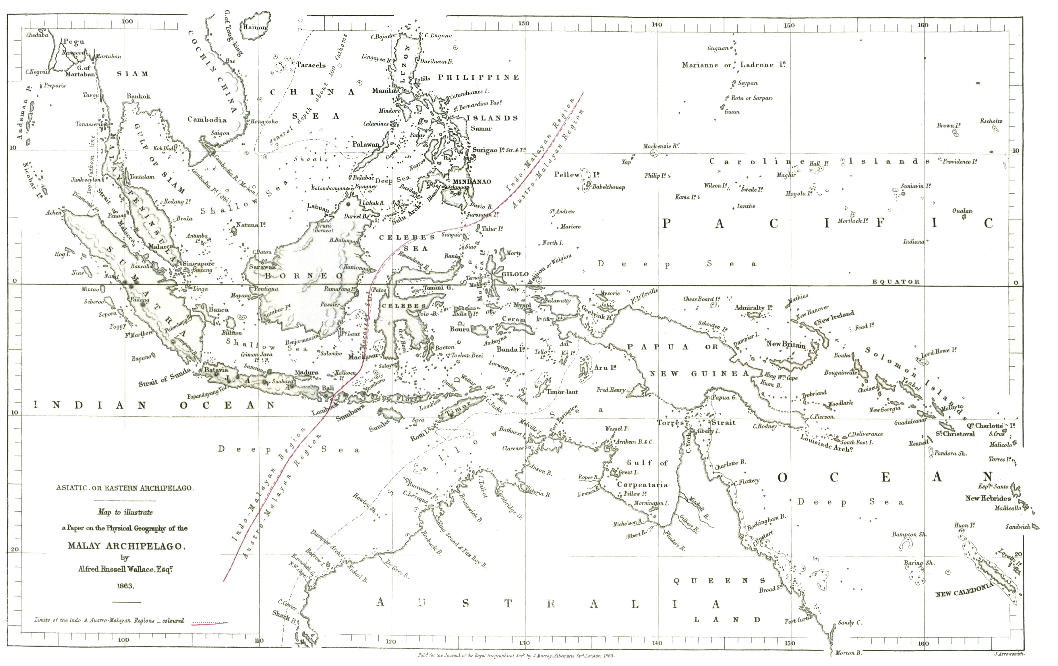
English: The original drawing of the 'Wallace Line' showing the division between Asian and Australasian flora and fauna reproduced at the internet archive |
|||||||||
| Թվական | ||||||||||
| Աղբյուր | On the Physical Geography of the Malay Archipelago | |||||||||
| Ստեղծել է |
Wallace, Alfred Russel; J. Arrowsmith |
|||||||||
| Geotemporal data | ||||||||||
| Bounding box |
|
|||||||||
| Georeferencing | ||||||||||
Արտոնագրում
|
This work is in the public domain in its country of origin and other countries and areas where the copyright term is the author's life plus 70 years or fewer. This work is in the public domain in the United States because it was published (or registered with the U.S. Copyright Office) before January 1, 1929. | |
| This file has been identified as being free of known restrictions under copyright law, including all related and neighboring rights. | |
Նիշքի պատմություն
Մատնահարեք օրվան/ժամին՝ նիշքի այդ պահին տեսքը դիտելու համար։
| Օր/Ժամ | Մանրապատկեր | Օբյեկտի չափը | Մասնակից | Մեկնաբանություն | |
|---|---|---|---|---|---|
| ընթացիկ | 01:41, 23 Մարտի 2022 | | 3685 × 2318 (3,6 ՄԲ) | Shyamal | Reduce whitespace on the right Cropped 12 % horizontally using CropTool with precise mode. |
| 05:25, 26 Օգոստոսի 2018 |  | 4208 × 2318 (3,4 ՄԲ) | Shyamal | Keep the colors | |
| 08:33, 19 Ապրիլի 2018 |  | 3632 × 2280 (1,84 ՄԲ) | Shyamal | Complete map | |
| 08:26, 19 Ապրիլի 2018 |  | 2100 × 2298 (1,28 ՄԲ) | Shyamal | Boost contrast | |
| 09:51, 25 Ապրիլի 2015 |  | 2100 × 2298 (515 ԿԲ) | Chris55 | User created page with UploadWizard |
Նիշքի օգտագործում
Հետևյալ 6 էջերը հղվում են այս նիշքին՝
Նիշքի համընդհանուր օգտագործում
Հետևյալ այլ վիքիները օգտագործում են այս նիշքը՝
- Օգտագործումը bg.wikipedia.org կայքում
- Օգտագործումը cy.wikipedia.org կայքում
- Օգտագործումը en.wikipedia.org կայքում
- Օգտագործումը fa.wikipedia.org կայքում
- Օգտագործումը gl.wikipedia.org կայքում
- Օգտագործումը it.wikipedia.org կայքում
- Օգտագործումը pt.wikipedia.org կայքում
- Օգտագործումը ta.wikipedia.org կայքում
- Օգտագործումը www.wikidata.org կայքում