
Պատկեր:Urartu in comparison with states in 2008-en.svg

Size of this PNG preview of this SVG file: 800 × 513 պիքսել. Այլ թույլտվությաններ: 320 × 205 պիքսել | 640 × 410 պիքսել | 1024 × 657 պիքսել | 1280 × 821 պիքսել | 2560 × 1641 պիքսել | 2714 × 1740 պիքսել.
Սկզբնական նիշք (SVG-նիշք, անվանապես 2714 × 1740 փիքսել, նիշքի չափը՝ 931 ԿԲ)
Ամփոփում
| Նկարագրում |
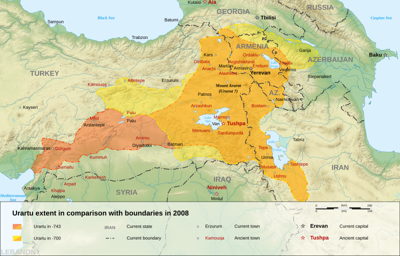
English: English map of a comparison with kingdom of Urartu in -743 and -700, and current states boundaries in 2008.
Français : Carte en anglais, comparant les frontières du royaume d'Urartu en -743 et -700, et les frontières des États actuels en 2008.
فارسی: نقشهای به زبان انگلیسی از پادشاهی اورارتو در ۷۴۳ و ۷۰۰ پیش از میلاد. |
||
| Թվական | |||
| Աղբյուր |
Own work.
Sources :
Softwares used :
Other data :
|
||
| Հեղինակ | Sémhur | ||
| Այլ մեկնակերպներ |
See Urartu.
| ||
| Հղում (required by the license) | © Sémhur / Wikimedia Commons / | ||
| SVG | W3C-validity not checked. Սա վեկտոր գրաֆիկական պատկեր է ստեղծված է եղել Inkscape օգնությամբ: .
|
||
| Atelier graphique |


| Տեսախցիկի տեղագրություն | | Այս և ուրիշ պատկերներ իրենց տեղագրությամբ OpenStreetMap |
|---|
Արտոնագրում
Ես, այս աշխատանքի հեղինակային իրավունքների տերը, ներկա հրատարակում եմ սրա հետևյալ լիցենզիաների պայմաններով
| Copyleft: This work of art is free; you can redistribute it and/or modify it according to terms of the Free Art License. You will find a specimen of this license on the Copyleft Attitude site as well as on other sites. |
This file is licensed under the Creative Commons Attribution-Share Alike 4.0 International, 3.0 Unported, 2.5 Generic, 2.0 Generic and 1.0 Generic license.
- Դուք ազատ եք՝
- կիսվել ստեղծագործությամբ – պատճենել, տարածել և փոխանցել այս աշխատանքը։
- վերափոխել – ադապտացնել աշխատանքը
- Պահպանելով հետևյալ պայմանները'
- հղում – Դուք պետք է նշեք հեղինակի (իրավատիրոջ) հղումը:
- համանման տարածում – Եթե դուք ձևափոխում եք, փոխակերպում, կամ այս աշխատանքի հիման վրա ստեղծում եք նոր աշխատանք, ապա ձեր ստեղծածը կարող է տարածվել միայն նույն կամ համարժեք թույլատրագրով։
Կարող եք ընտրել այս թույլատրագրերից ցանկացածը։
Նիշքի պատմություն
Մատնահարեք օրվան/ժամին՝ նիշքի այդ պահին տեսքը դիտելու համար։
| Օր/Ժամ | Մանրապատկեր | Օբյեկտի չափը | Մասնակից | Մեկնաբանություն | |
|---|---|---|---|---|---|
| ընթացիկ | 17:37, 8 հունվարի 2008 | | 2714 × 1740 (931 ԿԲ) | Sémhur | == Description == {{Information |Description= {{en| English map of a comparison with kingdom of Urartu in -743 and -700, and current states boundaries in 2008.}} {{fr| Carte en anglais, comparant les frontières du royaume d'Urartu en -743 et -700, et les |
Նիշքի օգտագործում
Այս նիշքին օգտագործող էջեր չկան։
Նիշքի համընդհանուր օգտագործում
Հետևյալ այլ վիքիները օգտագործում են այս նիշքը՝
- Օգտագործումը en.wikipedia.org կայքում
- Օգտագործումը eo.wikipedia.org կայքում
- Օգտագործումը et.wikipedia.org կայքում
- Օգտագործումը fa.wikipedia.org կայքում
- Օգտագործումը nn.wikipedia.org կայքում
- Օգտագործումը pl.wikipedia.org կայքում
- Օգտագործումը tr.wikipedia.org կայքում