
Պատկեր:Ukraine 2022-02-21.svg

Սկզբնական նիշք (SVG-նիշք, անվանապես 1546 × 1038 փիքսել, նիշքի չափը՝ 452 ԿԲ)
Ամփոփում
| Նկարագրում |
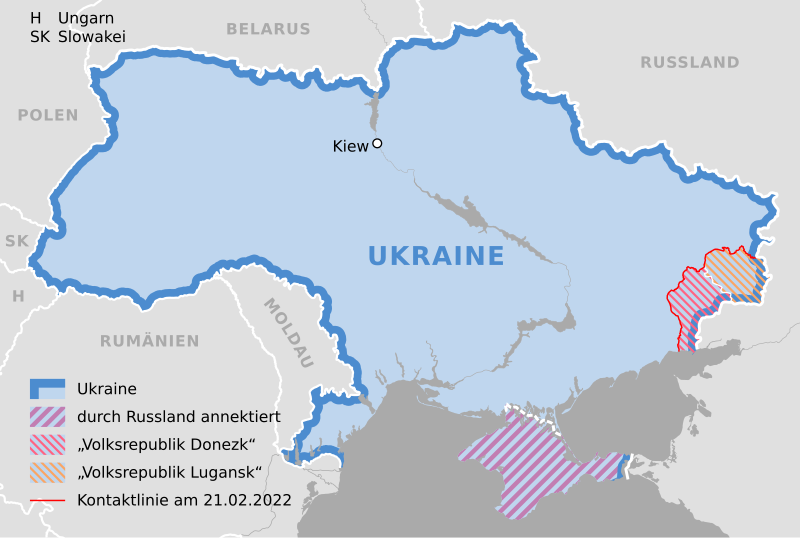
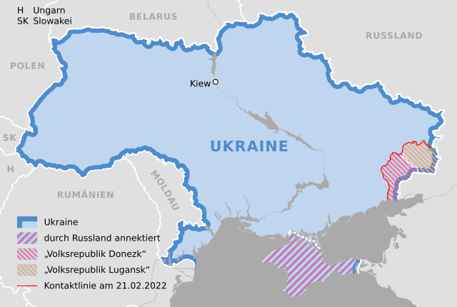
Deutsch: Karte der Ukraine, Stand 21. Februar 2022 |
||
| Թվական | |||
| Աղբյուր |
Own work using: Ukraine adm location map.svg by NordNordWest |
||
| Հեղինակ | NordNordWest | ||
| SVG genesis | Այս մասշտաբավորելի վեկտորային գրաֆիկայի նիշքի ելակետային կոդը վավեր է. Սա վեկտոր գրաֆիկական պատկեր է ստեղծված է եղել Adobe Illustrator by NordNordWest օգնությամբ: .
|

Արտոնագրում
Usage of this file with:

explanatory notes: Legally binding is only the full legalcode. For a free usage I recommend to respect the following licence conditions:
1. Provide my name as given above: NordNordWest,
2. a copy of, or the URI for, the applicable license: https://creativecommons.org/licenses/by-sa/3.0/de/legalcode,
3. the title of the work,
4. in the case of an adaptation, a credit identifying the use of the work in the adaptation.
This license and the rights granted hereunder will terminate automatically upon any breach by you of the terms of this license. Any of the above conditions can be waived if you get permission from the copyright holder. If you have questions or wish differing conditions, please contact me through nnwest or my discussion page ![]() t-online.de
t-online.de
- Դուք ազատ եք՝
- կիսվել ստեղծագործությամբ – պատճենել, տարածել և փոխանցել այս աշխատանքը։
- վերափոխել – ադապտացնել աշխատանքը
- Պահպանելով հետևյալ պայմանները'
- հղում – Դուք պետք է նշեք հեղինակի (իրավատիրոջ) հղումը:
- համանման տարածում – Եթե դուք ձևափոխում եք, փոխակերպում, կամ այս աշխատանքի հիման վրա ստեղծում եք նոր աշխատանք, ապա ձեր ստեղծածը կարող է տարածվել միայն նույն կամ համարժեք թույլատրագրով։

Նիշքի պատմություն
Մատնահարեք օրվան/ժամին՝ նիշքի այդ պահին տեսքը դիտելու համար։
| Օր/Ժամ | Մանրապատկեր | Օբյեկտի չափը | Մասնակից | Մեկնաբանություն | |
|---|---|---|---|---|---|
| ընթացիկ | 15:34, 27 փետրվարի 2022 | | 1546 × 1038 (452 ԿԲ) | NordNordWest | Reverted to version as of 14:40, 25 February 2022 (UTC); nein danke |
| 20:31, 26 փետրվարի 2022 |  | 1546 × 1038 (492 ԿԲ) | Kematen | Donezk weiter westlich | |
| 19:51, 25 փետրվարի 2022 |  | 1546 × 1038 (492 ԿԲ) | Kematen | übersichtlicher | |
| 14:40, 25 փետրվարի 2022 |  | 1546 × 1038 (452 ԿԲ) | NordNordWest | c | |
| 14:38, 25 փետրվարի 2022 |  | 1546 × 1038 (450 ԿԲ) | NordNordWest | c | |
| 21:40, 24 փետրվարի 2022 |  | 1546 × 1038 (442 ԿԲ) | NordNordWest | == {{int:filedesc}} == {{Information |description= {{de|1=Karte der Ukraine, Stand 21. Februar 2022}} |source={{Own using|Ukraine adm location map.svg|by=NordNordWest}} * https://www.osce.org/files/b/c/map_settlements--2022-02-20.jpg?itok=82567= |date={{Date|2022|02|24}} |author={{U|NordNordWest}} |permission= |other_versions= }} {{Kartenwerkstatt}} == {{int:license-header}} == {{User:NordNordWest/LicenceMap}} Category:Maps of the Russo-Ukrainian war Category:SVG maps of Ukraine [[... |
Նիշքի օգտագործում
Այս նիշքին օգտագործող էջեր չկան։
Նիշքի համընդհանուր օգտագործում
Հետևյալ այլ վիքիները օգտագործում են այս նիշքը՝
- Օգտագործումը als.wikipedia.org կայքում
- Օգտագործումը de.wikipedia.org կայքում
- Օգտագործումը en.wikipedia.org կայքում