
Պատկեր:Porthloo beach, St Mary's, Scilly - geograph.org.uk - 1607577.jpg
Ավելի բարձր կետաչափով տարբերակ չկա։
Porthloo_beach,_St_Mary's,_Scilly_-_geograph.org.uk_-_1607577.jpg (640 × 383 փիքսել, նիշքի չափը՝ 83 ԿԲ, MIME-տեսակը՝ image/jpeg)
Ամփոփում
| Նկարագրում |
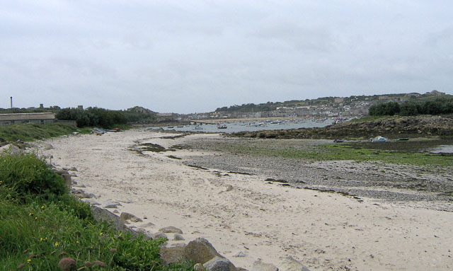
English: Porthloo beach, St Mary's, Scilly Porthloo has a nice sandy upper beach, but the middle shore is mainly occupied by shingle, rocks and weed. Not good for swimming, but from the seats nearby, you can watch shorebirds foraging amongst the rocks and weed. In the middle distance is the launching ramp for the St Mary's lifeboat at Carn Thomas. Beyond and to the right is St Mary's Pool, with many boats moored. The island to the middle right is Newford Island. The land to the upper right is the Garrison. |
| Թվական | |
| Աղբյուր | From geograph.org.uk |
| Հեղինակ | John Rostron |
| Հղում (required by the license) | John Rostron / Porthloo beach, St Mary's, Scilly / |
| Տեսախցիկի տեղագրություն | | Այս և ուրիշ պատկերներ իրենց տեղագրությամբ OpenStreetMap |
|---|
_heading:202.00&language=hy)
| Օբյեկտի տեղագրություն | | Այս և ուրիշ պատկերներ իրենց տեղագրությամբ OpenStreetMap |
|---|
_heading:202.00&language=hy)
Արտոնագրում

|
This image was taken from the Geograph project collection. See this photograph's page on the Geograph website for the photographer's contact details. The copyright on this image is owned by John Rostron and is licensed for reuse under the Creative Commons Attribution-ShareAlike 2.0 license.
|
This file is licensed under the Creative Commons Attribution-Share Alike 2.0 Generic license.
Հղում: John Rostron
- Դուք ազատ եք՝
- կիսվել ստեղծագործությամբ – պատճենել, տարածել և փոխանցել այս աշխատանքը։
- վերափոխել – ադապտացնել աշխատանքը
- Պահպանելով հետևյալ պայմանները'
- հղում – Դուք պետք է նշեք հեղինակի (իրավատիրոջ) հղումը:
- համանման տարածում – Եթե դուք ձևափոխում եք, փոխակերպում, կամ այս աշխատանքի հիման վրա ստեղծում եք նոր աշխատանք, ապա ձեր ստեղծածը կարող է տարածվել միայն նույն կամ համարժեք թույլատրագրով։
Նիշքի պատմություն
Մատնահարեք օրվան/ժամին՝ նիշքի այդ պահին տեսքը դիտելու համար։
| Օր/Ժամ | Մանրապատկեր | Օբյեկտի չափը | Մասնակից | Մեկնաբանություն | |
|---|---|---|---|---|---|
| ընթացիկ | 07:08, 4 Մարտի 2011 | | 640 × 383 (83 ԿԲ) | GeographBot | == {{int:filedesc}} == {{Information |description={{en|1=Porthloo beach, St Mary's, Scilly Porthloo has a nice sandy upper beach, but the middle shore is mainly occupied by shingle, rocks and weed. Not good for swimming, but from the seats nearby, you can |
Նիշքի օգտագործում
Հետևյալ էջը հղվում է այս նիշքին՝
Նիշքի համընդհանուր օգտագործում
Հետևյալ այլ վիքիները օգտագործում են այս նիշքը՝
- Օգտագործումը en.wikipedia.org կայքում
- Օգտագործումը eu.wikipedia.org կայքում
- Օգտագործումը gd.wikipedia.org կայքում
- Օգտագործումը pl.wikipedia.org կայքում
- Օգտագործումը www.wikidata.org կայքում