
Պատկեր:Missionary Ridge.png

Նախադիտման չափ՝ 351 × 599 պիքսել։ Այլ թույլտվությաններ: 140 × 240 պիքսել | 281 × 480 պիքսել | 450 × 768 պիքսել | 600 × 1024 պիքսել | 2000 × 3413 պիքսել.
Սկզբնական նիշք (2000 × 3413 փիքսել, նիշքի չափը՝ 1,16 ՄԲ, MIME-տեսակը՝ image/png)
Ամփոփում
| Նկարագրում | |
| Թվական | |
| Աղբյուր | Բեռնողի սեփական աշխատանք, derived from source http://www.posix.com/CWmaps/ (PD) |
| Հեղինակ | Hal Jespersen |
Արտոնագրում
This file is licensed under the Creative Commons Attribution 3.0 Unported license.
Հղում: Hal Jespersen, www.posix.com/CW
- Դուք ազատ եք՝
- կիսվել ստեղծագործությամբ – պատճենել, տարածել և փոխանցել այս աշխատանքը։
- վերափոխել – ադապտացնել աշխատանքը
- Պահպանելով հետևյալ պայմանները'
- հղում – Դուք պետք է նշեք հեղինակի (իրավատիրոջ) հղումը:
Original upload log
The original description page was here. All following user names refer to en.wikipedia.
- 2009-11-19 17:01 Hlj 1965×3398× (1018830 bytes) Updated Osterhaus's movement, based on 1896 War Dept map, available at http://historicalcharts.noaa.gov/historicals/historical_zoom.asp (map CWCK8 in the Tennessee series of CW maps). Same license.
- 2009-02-13 00:40 Hlj 1965×3398× (1014870 bytes) Corrected some unit movements. Same license. {{cc-by-3.0|Map by Hal Jespersen, www.posix.com/CW}}
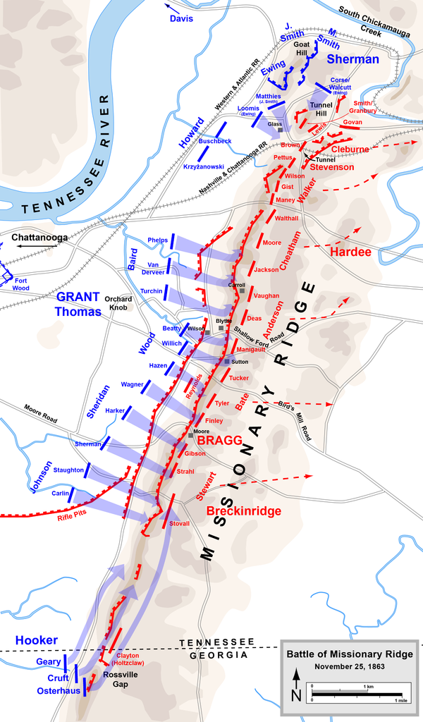
- 2009-01-31 23:03 Hlj 1965×3398× (995340 bytes) {{Information |Description=Map of [[Battle of Missionary Ridge]] of the [[American Civil War]]. Drawn in Adobe Illustrator CS3 by Hal Jespersen. Graphic source file is available at http://www.posix.com/CWmaps/ |Source=own work |Date= January 31, 2009 |Aut
Նիշքի պատմություն
Մատնահարեք օրվան/ժամին՝ նիշքի այդ պահին տեսքը դիտելու համար։
| Օր/Ժամ | Մանրապատկեր | Օբյեկտի չափը | Մասնակից | Մեկնաբանություն | |
|---|---|---|---|---|---|
| ընթացիկ | 23:31, 30 Մարտի 2011 | | 2000 × 3413 (1,16 ՄԲ) | Hlj | Updated graphical format of rivers and roads. Same license. |
| 15:23, 24 հունվարի 2010 |  | 1965 × 3398 (995 ԿԲ) | BotMultichill | {{BotMoveToCommons|en.wikipedia|year={{subst:CURRENTYEAR}}|month={{subst:CURRENTMONTHNAME}}|day={{subst:CURRENTDAY}}}} {{Information |Description={{en|Map of en:Battle of Missionary Ridge of the en:American Civil War. Drawn in Adobe Illustra |
Նիշքի օգտագործում
Հետևյալ էջը հղվում է այս նիշքին՝
Նիշքի համընդհանուր օգտագործում
Հետևյալ այլ վիքիները օգտագործում են այս նիշքը՝
- Օգտագործումը en.wikipedia.org կայքում
- Օգտագործումը fr.wikipedia.org կայքում
- Օգտագործումը nl.wikipedia.org կայքում
- Օգտագործումը ru.wikipedia.org կայքում