
Պատկեր:Misak-i milli.png

Նախադիտման չափ՝ 800 × 493 պիքսել։ Այլ թույլտվությաններ: 320 × 197 պիքսել | 640 × 395 պիքսել | 1024 × 631 պիքսել | 1474 × 909 պիքսել.
Սկզբնական նիշք (1474 × 909 փիքսել, նիշքի չափը՝ 204 ԿԲ, MIME-տեսակը՝ image/png)
Ամփոփում
| Նկարագրում |
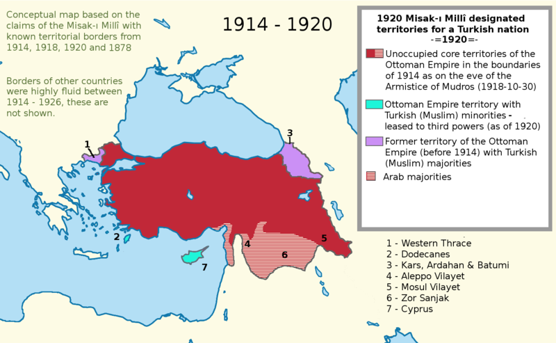
English: I worked more on the proposal map and I also added the current territories. This map shows the goal of the Turkish side. I used a Wikipedia map while I was working on this project. It is called "LocationTurkey2". --Please help me erasing the older one (Misak-ı_milli.PNG)--
Turkish variation: File:Misak-i_milli_tr.png |
| Թվական | 23 Փետրվար 2007 (original upload date) |
| Աղբյուր | Transferred from en.wikipedia to Commons. |
| Հեղինակ | Deliogul at անգլերեն Վիքիպեդիա |
Արտոնագրում
Deliogul from en.wikipedia.org, սույն աշխատանքի հեղինակային իրավունքների տերը, այսուհետ այն հրատարակում է հետևյալ արտոնագրի պայմաններով՝

|
Այս վավերագրման պատճենահանման, տարածման և/կամ ձևափոխման թույլտվություն կամ լիցենզիայի GNU FDL պայմաններով 1.2 մեկնակերպի կամ ավելի ուշ, հրատարակված Ազատ ծրագրային ապահովության հիմնադրամում, առանց անփոփոխելի հատվածների, առանց բնագիրների, որոնք տեղադրված են առաջին և վերջին շապիկներում: Լիցենզիայի պատճենը գտնվում է GNU Free Documentation License հատվածում: |
| Այս նիշքը հասանելի է Creative Commons Attribution-Share Alike 3.0 Unported արտոնագրի ներքո: | ||
| Հղում: Deliogul | ||
| ||
| Այս արտոնգրության հատկանիշը ավելացված է տվյալ նիշքին որպես GFDL արտոնագրի բարեփոխում: |
Original upload log
The original description page was here. All following user names refer to en.wikipedia.
- 2007-02-23 16:09 Deliogul 610×166×8 (27404 bytes) I worked more on the proposal map and I also added the current territories. This map shows the goal of the Turkish side. I used a Wikipedia map while I was working on this project. It is called "LocationTurkey2". --Please help me erasing the older one (Mi
Նիշքի պատմություն
Մատնահարեք օրվան/ժամին՝ նիշքի այդ պահին տեսքը դիտելու համար։
| Օր/Ժամ | Մանրապատկեր | Օբյեկտի չափը | Մասնակից | Մեկնաբանություն | |
|---|---|---|---|---|---|
| ընթացիկ | 21:43, 30 Նոյեմբերի 2016 | | 1474 × 909 (204 ԿԲ) | ScienceDawns | Removed redundant information, weasel word, cropped to part a until reliable encyclopedic sources can be provided linking the current situation to the Misak-ı Millî decisions. |
| 20:48, 11 Նոյեմբերի 2016 |  | 1474 × 1826 (508 ԿԲ) | Metrancya | Complete replacement of the original file - the accuracy of the old file was disputed and the content of the old file did not match the text of the Misak-ı millî. The new file follows the Misak-ı millî word-by-word and outlines the original designa... | |
| 22:47, 9 Ապրիլի 2008 | 610 × 166 (27 ԿԲ) | KureCewlik81 | {{Information |Description={{en|I worked more on the proposal map and I also added the current territories. This map shows the goal of the Turkish side. I used a Wikipedia map while I was working on this project. It is called "LocationTurkey2". --Please h |
Նիշքի օգտագործում
Հետևյալ էջը հղվում է այս նիշքին՝
Նիշքի համընդհանուր օգտագործում
Հետևյալ այլ վիքիները օգտագործում են այս նիշքը՝
- Օգտագործումը ar.wikipedia.org կայքում
- Օգտագործումը arz.wikipedia.org կայքում
- Օգտագործումը azb.wikipedia.org կայքում
- Օգտագործումը az.wikipedia.org կայքում
- Օգտագործումը ca.wikipedia.org կայքում
- Օգտագործումը de.wikipedia.org կայքում
- Օգտագործումը el.wikipedia.org կայքում
- Օգտագործումը en.wikipedia.org կայքում
- Օգտագործումը he.wikipedia.org կայքում
- Օգտագործումը hu.wikipedia.org կայքում
- Օգտագործումը it.wikipedia.org կայքում
- Օգտագործումը mk.wikipedia.org կայքում
- Օգտագործումը nl.wikipedia.org կայքում
- Օգտագործումը pnb.wikipedia.org կայքում
- Օգտագործումը pt.wikipedia.org կայքում
- Օգտագործումը ru.wikipedia.org կայքում
- Օգտագործումը tr.wikipedia.org կայքում
- Օգտագործումը uk.wikipedia.org կայքում
- Օգտագործումը ur.wikipedia.org կայքում
- Օգտագործումը www.wikidata.org կայքում