
Պատկեր:Map of Utah highlighting Duchesne County.svg

Size of this PNG preview of this SVG file: 480 × 600 պիքսել. Այլ թույլտվությաններ: 192 × 240 պիքսել | 384 × 480 պիքսել | 615 × 768 պիքսել | 820 × 1024 պիքսել | 1639 × 2048 պիքսել | 891 × 1113 պիքսել.
Սկզբնական նիշք (SVG-նիշք, անվանապես 891 × 1113 փիքսել, նիշքի չափը՝ 52 ԿԲ)
Ամփոփում
| Նկարագրում |
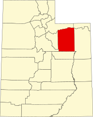
English: This is a locator map showing Duchesne County in Utah. For more information, see Commons:United States county locator maps. |
| Թվական | |
| Աղբյուր |
Բեռնողի սեփական աշխատանք: English: The maps use data from nationalatlas.gov, specifically countyp020.tar.gz on the Raw Data Download page. The maps also use state outline data from statesp020.tar.gz. The Florida maps use hydrogm020.tar.gz to display Lake Okeechobee. |
| Հեղինակ | David Benbennick |
Արտոնագրում
| I, the copyright holder of this work, release this work into the public domain. This applies worldwide. In some countries this may not be legally possible; if so: I grant anyone the right to use this work for any purpose, without any conditions, unless such conditions are required by law. |
Նիշքի պատմություն
Մատնահարեք օրվան/ժամին՝ նիշքի այդ պահին տեսքը դիտելու համար։
| Օր/Ժամ | Մանրապատկեր | Օբյեկտի չափը | Մասնակից | Մեկնաբանություն | |
|---|---|---|---|---|---|
| ընթացիկ | 22:21, 24 Հունիսի 2024 | | 891 × 1113 (52 ԿԲ) | Nux | fix rendering (remove clipping) |
| 17:34, 12 փետրվարի 2006 |  | 4457 × 5566 (56 ԿԲ) | David Benbennick | {{subst:User:Dbenbenn/clm|county=Duchesne County|state=Utah|type=county}} |
Նիշքի օգտագործում
Հետևյալ էջը հղվում է այս նիշքին՝
Նիշքի համընդհանուր օգտագործում
Հետևյալ այլ վիքիները օգտագործում են այս նիշքը՝
- Օգտագործումը ar.wikipedia.org կայքում
- Օգտագործումը be.wikipedia.org կայքում
- Օգտագործումը bg.wikipedia.org կայքում
- Օգտագործումը bpy.wikipedia.org կայքում
- Օգտագործումը ca.wikipedia.org կայքում
- Օգտագործումը cdo.wikipedia.org կայքում
- Օգտագործումը ceb.wikipedia.org կայքում
- Օգտագործումը cs.wikipedia.org կայքում
- Օգտագործումը cy.wikipedia.org կայքում
- Օգտագործումը de.wikipedia.org կայքում
- Օգտագործումը diq.wikipedia.org կայքում
- Օգտագործումը en.wikipedia.org կայքում
- Duchesne County, Utah
- List of counties in Utah
- Altamont, Utah
- Duchesne, Utah
- Myton, Utah
- Neola, Utah
- Roosevelt, Utah
- Tabiona, Utah
- Uintah and Ouray Indian Reservation
- Template:Duchesne County, Utah
- Harper, Utah
- Talmage, Utah
- Altonah, Utah
- Bluebell, Utah
- Fruitland, Utah
- Hanna, Utah
- Mountain Home, Utah
- User:Nyttend/County templates/UT
- Fred Hayes State Park at Starvation
- Strawberry, Utah
- National Register of Historic Places listings in Duchesne County, Utah
Տեսնել այս նիշքի ավելի համընդհանուր օգտագործումը: