
Պատկեր:Irland karte.png
Նախադիտման չափ՝ 503 × 600 պիքսել։ Այլ թույլտվությաններ: 201 × 240 պիքսել | 402 × 480 պիքսել | 644 × 768 պիքսել | 858 × 1024 պիքսել | 1473 × 1757 պիքսել.
Սկզբնական նիշք (1473 × 1757 փիքսել, նիշքի չափը՝ 1,25 ՄԲ, MIME-տեսակը՝ image/png)
|
| Նկարագրում |
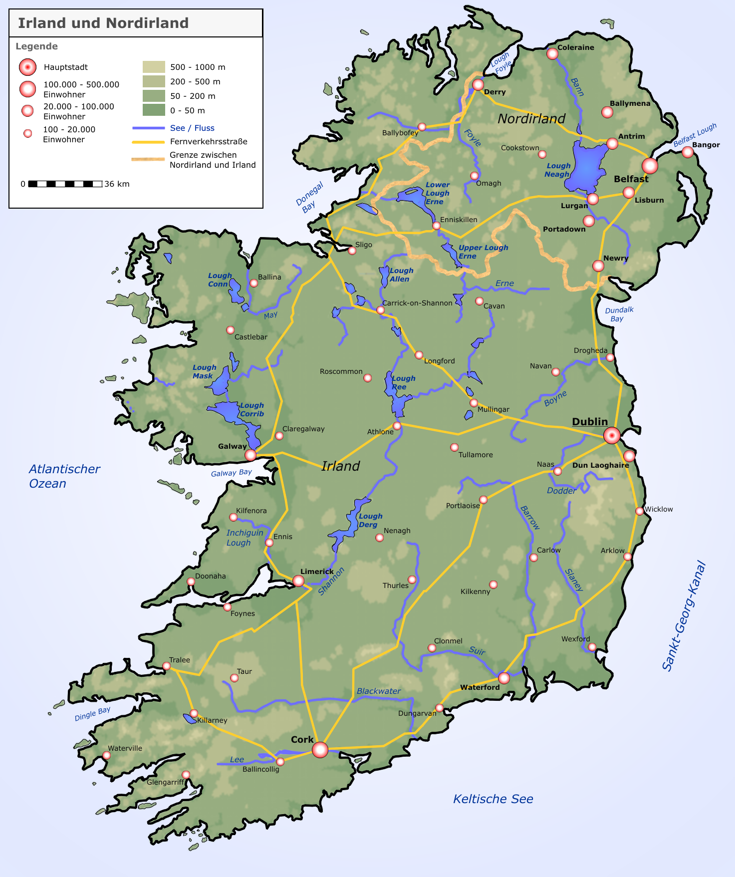
Deutsch: Neue Karte von Irland und Nordirland |
| Թվական | |
| Աղբյուր |
selbst erstellt von Roger Zenner
|
| Հեղինակ | Roger Zenner |
| Իրավունքներ (Նիշքի վերաօգտագործումը) |
CC-by-sa-2.0-de |
| Այլ մեկնակերպներ |
copied from de.wikipedia [1]:
|
![[1]](https://de.wikipedia.org/wiki/Bild:Irland_karte.png)
This file is licensed under the Creative Commons Attribution-Share Alike 2.0 Germany license.
- Դուք ազատ եք՝
- կիսվել ստեղծագործությամբ – պատճենել, տարածել և փոխանցել այս աշխատանքը։
- վերափոխել – ադապտացնել աշխատանքը
- Պահպանելով հետևյալ պայմանները'
- հղում – Դուք պետք է նշեք հեղինակի (իրավատիրոջ) հղումը:
- համանման տարածում – Եթե դուք ձևափոխում եք, փոխակերպում, կամ այս աշխատանքի հիման վրա ստեղծում եք նոր աշխատանք, ապա ձեր ստեղծածը կարող է տարածվել միայն նույն կամ համարժեք թույլատրագրով։


|
This map image could be re-created using vector graphics as an SVG file. This has several advantages; see Commons:Media for cleanup for more information. If an SVG form of this image is available, please upload it and afterwards replace this template with
{{vector version available|new image name}}.
It is recommended to name the SVG file “Irland karte.svg”—then the template Vector version available (or Vva) does not need the new image name parameter. |
Նիշքի պատմություն
Մատնահարեք օրվան/ժամին՝ նիշքի այդ պահին տեսքը դիտելու համար։
| Օր/Ժամ | Մանրապատկեր | Օբյեկտի չափը | Մասնակից | Մեկնաբանություն | |
|---|---|---|---|---|---|
| ընթացիկ | 09:05, 17 Սեպտեմբերի 2005 | | 1473 × 1757 (1,25 ՄԲ) | Saperaud~commonswiki | neue Karte von Irland und Nordirland Lizenz: Das Bild wurde von Benutzer:Roger_Zenner gezeichnet und wurde unter der CC-by-sa/2.0/de veröffentlicht. *Version 1.6: Höhenstufen weicher *Version 1.5: Londonderry heißt nun Derry, Beschriftungen angep |
Նիշքի օգտագործում
Հետևյալ էջը հղվում է այս նիշքին՝
Նիշքի համընդհանուր օգտագործում
Հետևյալ այլ վիքիները օգտագործում են այս նիշքը՝
- Օգտագործումը ar.wikipedia.org կայքում
- Օգտագործումը ca.wikipedia.org կայքում
- Օգտագործումը cs.wikipedia.org կայքում
- Օգտագործումը da.wikipedia.org կայքում
- Օգտագործումը de.wikipedia.org կայքում
- Irland (Insel)
- Irland
- Wikipedia:Kandidaten für exzellente Bilder/Archiv2004/4
- Benutzer:Roger Zenner/Bilder
- Datei:Irland karte.png
- Benutzer:Cmoder/Grafiktipps
- Wikipedia:Exzellente Bilder/Karten und Satellitenbilder
- Benutzer:Uwe Dedering/Länderliste
- Benutzer:Ulflulfl/Karten
- Vorlage:Infobox Insel/Erprobung Karte in einer Ecke
- Vorlage:Infobox Insel/Erprobung Karte in einer Ecke/Doku
- Օգտագործումը de.wiktionary.org կայքում
- Օգտագործումը eo.wikipedia.org կայքում
- Օգտագործումը et.wikipedia.org կայքում
- Օգտագործումը frr.wikipedia.org կայքում
- Օգտագործումը fr.wikipedia.org կայքում
- Օգտագործումը ga.wikipedia.org կայքում
- Օգտագործումը kab.wikipedia.org կայքում
- Օգտագործումը lb.wikipedia.org կայքում
- Օգտագործումը pfl.wikipedia.org կայքում
- Օգտագործումը pl.wikipedia.org կայքում
- Shannon (rzeka)
- Geografia Irlandii
- Boyne
- Lee (rzeka w Irlandii)
- Wikipedysta:DodekBot/lista-de
- Wikipedysta:DodekBot/lista-de2
- Corrib
- Liffey
- Blackwater (Meath)
- Slaney
- Munster Blackwater
- Barrow (rzeka)
- Brosna (rzeka)
- Suir
- Nore
- Erne
- Camac
- Tolka
- Dodder
- Mulkear
- Laune
- Blackwater (Kerry)
- Blackwater (Ulster)
- Finn (rzeka)
- Feale
Տեսնել այս նիշքի ավելի համընդհանուր օգտագործումը: