
Պատկեր:First Republic of Armenia in 1918-1920.png

Նախադիտման չափ՝ 799 × 348 պիքսել։ Այլ թույլտվությաններ: 320 × 139 պիքսել | 640 × 279 պիքսել | 1024 × 446 պիքսել | 1280 × 558 պիքսել | 2560 × 1115 պիքսել | 8192 × 3568 պիքսել.
Սկզբնական նիշք (8192 × 3568 փիքսել, նիշքի չափը՝ 14,85 ՄԲ, MIME-տեսակը՝ image/png)
Ամփոփում
| Նկարագրում |
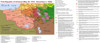
English: The First Republic of Armenia in 1918-1920. |
| Թվական | |
| Աղբյուր | Բեռնողի սեփական աշխատանք |
| Հեղինակ | Accipite7 |
Արտոնագրում
Ես, սույն աշխատանքի հեղինակային իրավունքների տերը, այսուհետ այն հրատարակում եմ հետևյալ արտոնագրի ներքո։
This file is licensed under the Creative Commons Attribution-Share Alike 4.0 International license.
- Դուք ազատ եք՝
- կիսվել ստեղծագործությամբ – պատճենել, տարածել և փոխանցել այս աշխատանքը։
- վերափոխել – ադապտացնել աշխատանքը
- Պահպանելով հետևյալ պայմանները'
- հղում – Դուք պետք է նշեք հեղինակի (իրավատիրոջ) հղումը:
- համանման տարածում – Եթե դուք ձևափոխում եք, փոխակերպում, կամ այս աշխատանքի հիման վրա ստեղծում եք նոր աշխատանք, ապա ձեր ստեղծածը կարող է տարածվել միայն նույն կամ համարժեք թույլատրագրով։
Նիշքի պատմություն
Մատնահարեք օրվան/ժամին՝ նիշքի այդ պահին տեսքը դիտելու համար։
| Օր/Ժամ | Մանրապատկեր | Օբյեկտի չափը | Մասնակից | Մեկնաբանություն | |
|---|---|---|---|---|---|
| ընթացիկ | 15:13, 2 Հունիսի 2021 | | 8192 × 3568 (14,85 ՄԲ) | Accipite7 | for the convenience of viewing small details, the size is increased, the colors are improved |
| 08:17, 25 Մայիսի 2021 |  | 4096 × 1784 (3,69 ՄԲ) | Accipite7 | The border between Nahang of Shirak and Nahang of Syunik has been clarified. | |
| 09:59, 21 Մայիսի 2021 |  | 4096 × 1784 (3,7 ՄԲ) | Accipite7 | The temporary border between the Republic of Armenia and the Soviet republics (August 10, 1920) in the Nakhichevan county has been clarified. Added a legend marked on the map under the number 26. | |
| 08:35, 13 Մայիսի 2021 |  | 4096 × 1784 (3,97 ՄԲ) | Accipite7 | fixed typo | |
| 08:27, 13 Մայիսի 2021 |  | 4096 × 1784 (3,97 ՄԲ) | Accipite7 | The names of the types of administrative units of the former Russian Empire have been clarified: uyezd = county, okrug = district, oblast = territory, guberniya = governorate. | |
| 11:14, 12 Մայիսի 2021 |  | 4096 × 1784 (3,71 ՄԲ) | Accipite7 | Corrected data in the map legend regarding what is indicated on the map by numbers. Clarified the boundaries of the territories required at the Paris Peace Conference. I strongly ask the user of Culminatio not to vandalize and not return the map to the version on which he marked the line reached as a result of the Turkish offensive in 1920. Since, firstly, it is neural: Batumi, Artvin and Ardahan were under the control of the Democratic Republic of Georgia until February-March 1921. And secon... | |
| 04:13, 12 Մայիսի 2021 |  | 5375 × 2341 (7,18 ՄԲ) | Culminatio | Reverted to version as of 15:05, 8 May 2021 (UTC) | |
| 07:11, 11 Մայիսի 2021 |  | 4096 × 1784 (3,99 ՄԲ) | Accipite7 | The boundaries of the territory of the demands of the Armenian delegation in the Transcaucasus, submitted to the Paris Peace Conference of 1919, were clarified. There is no need to overload the map with the line reached by the Turkish forces in 1920, as the map already shows the results of the Armenian-Turkish war of 1920 - the border according to the Treaty of Alexandropol, December 2, 1920 | |
| 15:05, 8 Մայիսի 2021 |  | 5375 × 2341 (7,18 ՄԲ) | Culminatio | Additional line of the turkish advance on the northern positions during the war of 1920. Additional numbers 10,19,20,21 on the map. | |
| 10:49, 8 Մայիսի 2021 |  | 6336 × 2760 (2,21 ՄԲ) | Accipite7 | Improved colors. |
Նիշքի օգտագործում
Հետևյալ 2 էջերը հղվում են այս նիշքին՝
Նիշքի համընդհանուր օգտագործում
Հետևյալ այլ վիքիները օգտագործում են այս նիշքը՝
- Օգտագործումը az.wikipedia.org կայքում
- Օգտագործումը be.wikipedia.org կայքում
- Օգտագործումը bg.wikipedia.org կայքում
- Օգտագործումը de.wikipedia.org կայքում
- Օգտագործումը el.wikipedia.org կայքում
- Օգտագործումը fi.wikipedia.org կայքում
- Օգտագործումը fr.wikipedia.org կայքում
- Օգտագործումը it.wikipedia.org կայքում
- Օգտագործումը nl.wikipedia.org կայքում
- Օգտագործումը pl.wikipedia.org կայքում
- Օգտագործումը pt.wikipedia.org կայքում
- Օգտագործումը ro.wikipedia.org կայքում
- Օգտագործումը ru.wikipedia.org կայքում
- Օգտագործումը sr.wikipedia.org կայքում
- Օգտագործումը uk.wikipedia.org կայքում
- Օգտագործումը zh.wikipedia.org կայքում