
Պատկեր:Europe, 1700—1714.png

Նախադիտման չափ՝ 800 × 546 պիքսել։ Այլ թույլտվությաններ: 320 × 219 պիքսել | 640 × 437 պիքսել | 1024 × 699 պիքսել | 1280 × 874 պիքսել | 1590 × 1086 պիքսել.
Սկզբնական նիշք (1590 × 1086 փիքսել, նիշքի չափը՝ 1,07 ՄԲ, MIME-տեսակը՝ image/png)

|
This map of europe image could be re-created using vector graphics as an SVG file. This has several advantages; see Commons:Media for cleanup for more information. If an SVG form of this image is available, please upload it and afterwards replace this template with
{{vector version available|new image name}}.
It is recommended to name the SVG file “Europe, 1700—1714.svg”—then the template Vector version available (or Vva) does not need the new image name parameter. |
Ամփոփում
| Նկարագրում |
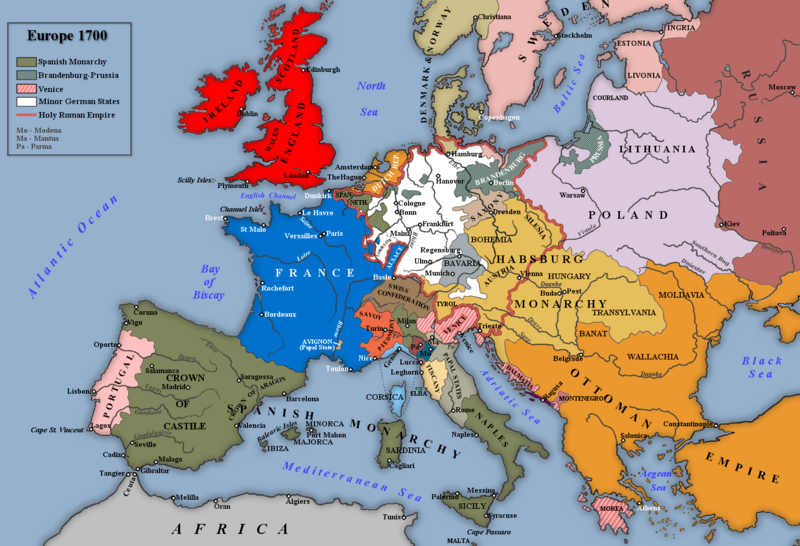
English: Map of Europe 1700. |
| Թվական | |
| Աղբյուր |
Own work based on: an image in Trevelyan, George Macaulay (1930) England Under Queen Anne, I, Լոնդոն: Longmans, Green and Co.
|
| Հեղինակ | Rebel Redcoat |
| Այլ մեկնակերպներ |
.png)
Արտոնագրում
| I, the copyright holder of this work, release this work into the public domain. This applies worldwide. In some countries this may not be legally possible; if so: I grant anyone the right to use this work for any purpose, without any conditions, unless such conditions are required by law. |
Նիշքի պատմություն
Մատնահարեք օրվան/ժամին՝ նիշքի այդ պահին տեսքը դիտելու համար։
| Օր/Ժամ | Մանրապատկեր | Օբյեկտի չափը | Մասնակից | Մեկնաբանություն | |
|---|---|---|---|---|---|
| ընթացիկ | 18:07, 7 Նոյեմբերի 2022 | | 1590 × 1086 (1,07 ՄԲ) | Gyalu22 | Reverted to version as of 18:08, 26 November 2018 (UTC) |
| 10:06, 19 հունվարի 2019 |  | 1590 × 1086 (1,08 ՄԲ) | Julieta39 | Some details according with Stier, H.E. (dir.) ''Grosser Atlas zur Weltgeschichte'', Westermann 1985, {{ISBN|3-14-100919-8}}; ''Putzger historischer Weltatlas'', Cornelsen 1990, {{ISBN|3-464-00176-8}}; Sellier, André & Jean (dir.) « Atlas des Peuples », La Découverte publ.: ''Europe occidentale'', 1995, {{ISBN|2-7071-2505-9}}, ''Europe centrale'', 1992, {{ISBN|2-7071-2032-4}}, ''Orient'', 1993, {{ISBN|2-7071-2222-X}}; ''Atlas istorico-geografic'', Bucharest, Academic publ. {{ISBN|973-27-0500... | |
| 18:08, 26 Նոյեմբերի 2018 |  | 1590 × 1086 (1,07 ՄԲ) | Goran tek-en | Changed name on rivers, Southern Bug and Dniester as requested by user:Gikü | |
| 19:18, 7 հունվարի 2014 |  | 1590 × 1086 (1004 ԿԲ) | Rebel Redcoat~commonswiki | Some minor improvements/accuracy | |
| 12:22, 5 Մայիսի 2012 |  | 1590 × 1086 (1,07 ՄԲ) | Rebel Redcoat~commonswiki | Better version | |
| 12:39, 22 Սեպտեմբերի 2010 |  | 1594 × 1090 (245 ԿԲ) | Altes | there was not S.-Petersburg in 1700 | |
| 14:54, 21 հունվարի 2010 |  | 1594 × 1090 (224 ԿԲ) | Rebel Redcoat~commonswiki | Improvements | |
| 13:58, 27 Մայիսի 2009 |  | 1594 × 1090 (210 ԿԲ) | Rebel Redcoat~commonswiki | Decreased Colour Depth | |
| 13:56, 27 Մայիսի 2009 |  | 1594 × 1090 (619 ԿԲ) | Rebel Redcoat~commonswiki | Minor Changes | |
| 17:35, 8 Մայիսի 2009 |  | 1594 × 1090 (210 ԿԲ) | Rebel Redcoat~commonswiki | Minor Changes |
Նիշքի օգտագործում
Հետևյալ էջը հղվում է այս նիշքին՝
Նիշքի համընդհանուր օգտագործում
Հետևյալ այլ վիքիները օգտագործում են այս նիշքը՝
- Օգտագործումը arz.wikipedia.org կայքում
- Օգտագործումը azb.wikipedia.org կայքում
- Օգտագործումը bo.wikipedia.org կայքում
- Օգտագործումը ca.wikipedia.org կայքում
- Օգտագործումը cs.wikipedia.org կայքում
- Օգտագործումը cv.wikipedia.org կայքում
- Օգտագործումը da.wikipedia.org կայքում
- Օգտագործումը el.wikipedia.org կայքում
- Օգտագործումը en.wikipedia.org կայքում
- Օգտագործումը en.wikibooks.org կայքում
- Օգտագործումը eo.wikipedia.org կայքում
- Օգտագործումը es.wikipedia.org կայքում
- Օգտագործումը et.wikipedia.org կայքում
- Օգտագործումը fr.wikipedia.org կայքում
- Օգտագործումը fr.wikiversity.org կայքում
- Օգտագործումը hi.wikibooks.org կայքում
- Օգտագործումը hr.wikipedia.org կայքում
- Օգտագործումը hu.wikipedia.org կայքում
- Օգտագործումը ia.wikipedia.org կայքում
- Օգտագործումը it.wikipedia.org կայքում
- Օգտագործումը ja.wikipedia.org կայքում
- Օգտագործումը jv.wikipedia.org կայքում
- Օգտագործումը mk.wikipedia.org կայքում
- Օգտագործումը ml.wikipedia.org կայքում
- Օգտագործումը nl.wikipedia.org կայքում
- Օգտագործումը nn.wikipedia.org կայքում
- Օգտագործումը no.wikipedia.org կայքում
- Օգտագործումը pnb.wikipedia.org կայքում
- Օգտագործումը pt.wikipedia.org կայքում
- Օգտագործումը ro.wikipedia.org կայքում
Տեսնել այս նիշքի ավելի համընդհանուր օգտագործումը: