
Պատկեր:China-Historic macro areas.svg

Սկզբնական նիշք (SVG-նիշք, անվանապես 1438 × 1047 փիքսել, նիշքի չափը՝ 3,61 ՄԲ)
Ամփոփում
| Նկարագրում |
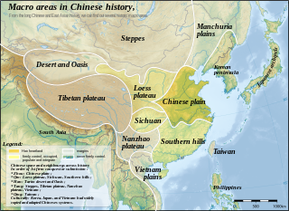
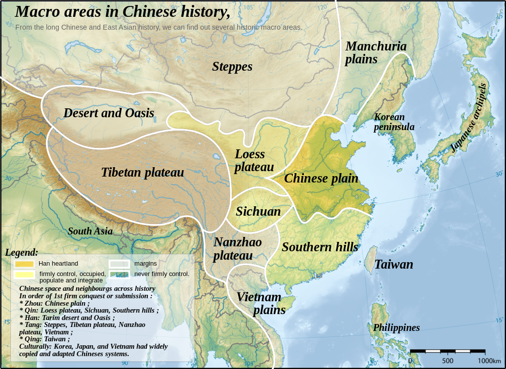
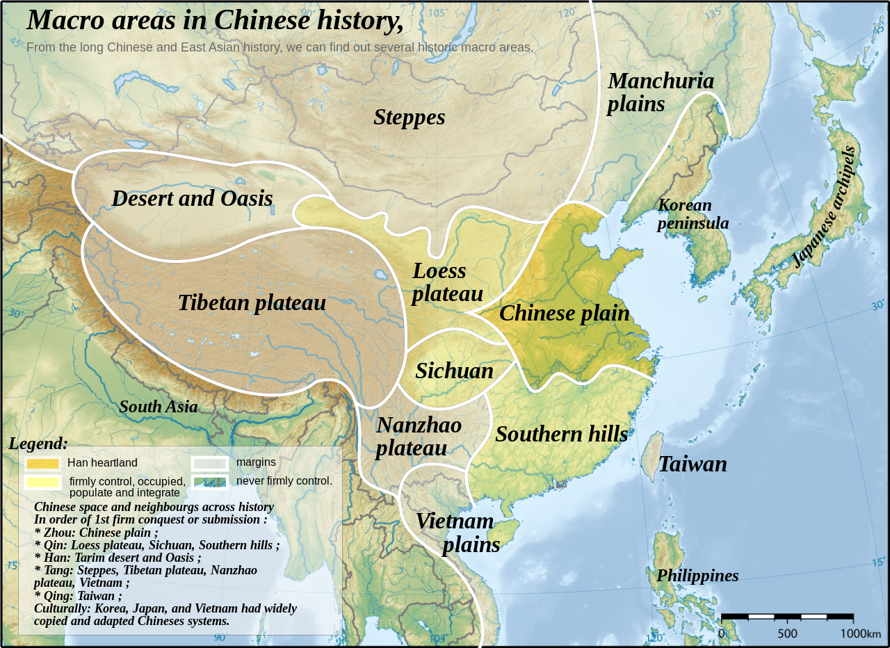
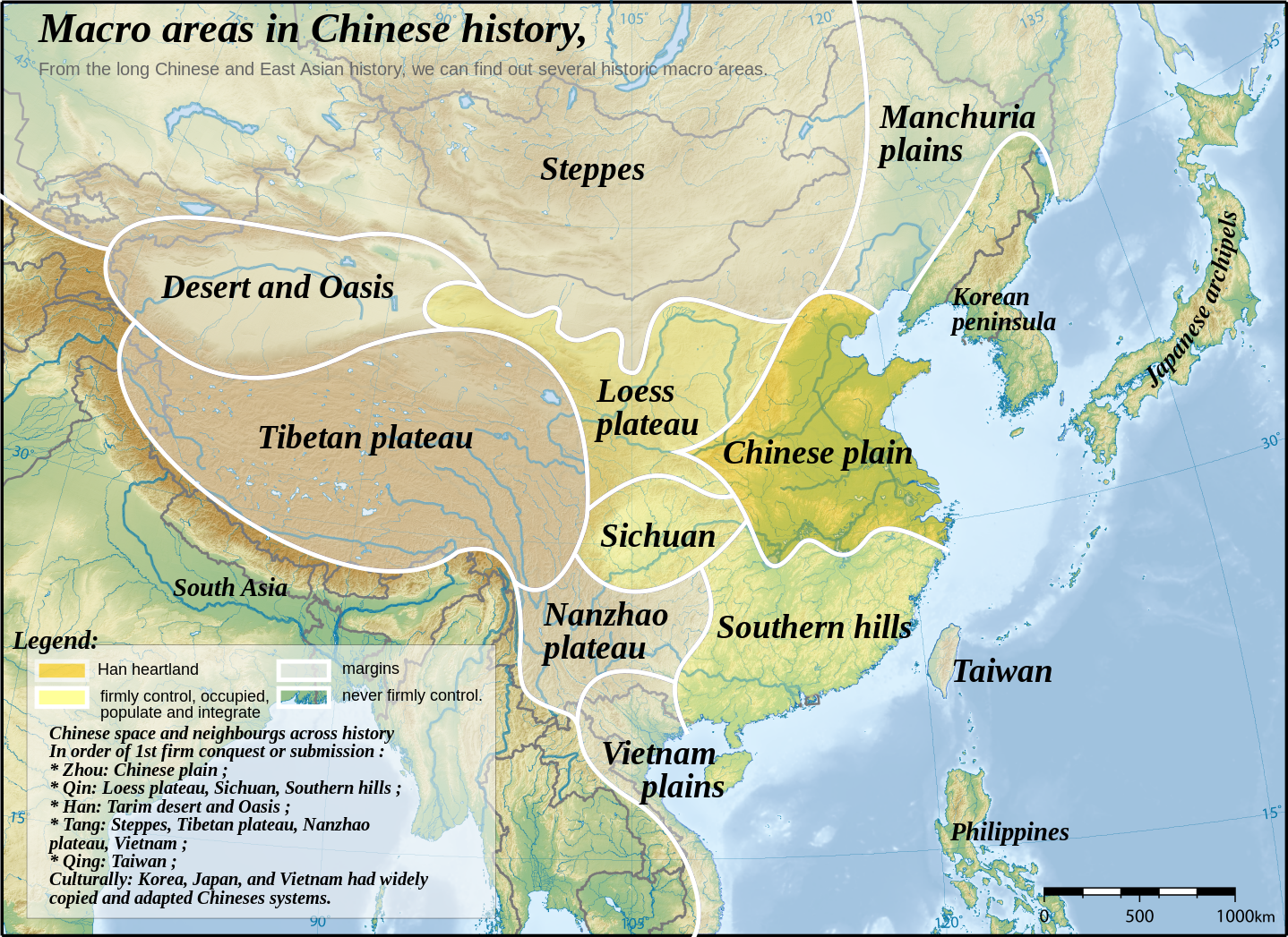
English: Topographic map of East Asia, with historical areas and macro-regions of China depicted.
中文(简体):东亚地形图。
中文(繁體):東亞地形圖。
日本語: 東アジアの地形図。
한국어: 동아시아의 지형도.
Tiếng Việt: Bản đồ địa hình khu vực Đông Á.
Català: Mapa topogràfic de l'Àsia Oriental, amb les macroàrees històriques de la Xina descrites. |
||
| Թվական | |||
| Աղբյուր | East Asia topographic map.png by Ksiom | ||
| Հեղինակ | Yug | ||
| Այլ մեկնակերպներ |
File:China-Historic macro areas.svg has 2 translations.
|
||
| SVG genesis | Սա վեկտոր գրաֆիկական պատկեր է ստեղծված է եղել Inkscape օգնությամբ: .
|


see also: http://uk.wikipedia.org/wiki/%D0%A4%D0%B0%D0%B9%D0%BB:China-Historic_macro_areas-uk.png
The map has been created with the Generic Mapping Tools: https://www.generic-mapping-tools.org/ using one or more of these public-domain datasets for the relief:
|

|
Այս վավերագրման պատճենահանման, տարածման և/կամ ձևափոխման թույլտվություն կամ լիցենզիայի GNU FDL պայմաններով 1.2 մեկնակերպի կամ ավելի ուշ, հրատարակված Ազատ ծրագրային ապահովության հիմնադրամում, առանց անփոփոխելի հատվածների, առանց բնագիրների, որոնք տեղադրված են առաջին և վերջին շապիկներում: Լիցենզիայի պատճենը գտնվում է GNU Free Documentation License հատվածում: |
| Այս նիշքը հասանելի է Creative Commons Attribution-Share Alike 3.0 Unported արտոնագրի ներքո: | ||
| ||
| Այս արտոնգրության հատկանիշը ավելացված է տվյալ նիշքին որպես GFDL արտոնագրի բարեփոխում: |

|
Այս SVG ֆայլ օգտագործում է զետեղված տեքստ, որը կարելի է հեշտ թարգմանել ձեր լեզվի վրա using [toolforge:svgtranslate/File:China-Historic_macro_areas.svglink this automated tool]: Իմացեք ավելին: You can also download it and translate it manually using a text editor. |
This file is translated using SVG For most Wikipedia projects, you can embed the file normally (without a To translate the text into your language, you can use the SVG Translate tool. Alternatively, you can download the file to your computer, add your translations using whatever software you're familiar with, and re-upload it with the same name. You will find help in Graphics Lab if you're not sure how to do this. |
Original upload log
This image is a derivative work of the following images:
- East Asia topographic map.png licensed with GFDL-GMT
- 2008-08-17T05:11:19Z Ksiom 2876x2094 (9245630 Bytes) {{Information |Description={{en|1=Topographic map of East Asia.}} {{ko|1=동아시아의 지형도.}} |Source=Own work by uploader |Author=[[User:Ksiom|Ksiom]] |Date=2008-08-17 |Permission={{GFDL-GMT}} |other_versions= }} [
Uploaded with derivativeFX
Նիշքի պատմություն
Մատնահարեք օրվան/ժամին՝ նիշքի այդ պահին տեսքը դիտելու համար։
| Օր/Ժամ | Մանրապատկեր | Օբյեկտի չափը | Մասնակից | Մեկնաբանություն | |
|---|---|---|---|---|---|
| ընթացիկ | 13:48, 18 Սեպտեմբերի 2023 | | 1438 × 1047 (3,61 ՄԲ) | JoanSMF | File uploaded using svgtranslate tool (https://svgtranslate.toolforge.org/). Added translation for ca. |
| 12:50, 18 Սեպտեմբերի 2023 |  | 1438 × 1047 (3,6 ՄԲ) | JoanSMF | File uploaded using svgtranslate tool (https://svgtranslate.toolforge.org/). Added translation for ca. | |
| 16:19, 13 Դեկտեմբերի 2008 |  | 1438 × 1047 (3,59 ՄԲ) | Yug | ||
| 16:01, 13 Դեկտեմբերի 2008 |  | 1438 × 1047 (267 ԿԲ) | Yug | ||
| 11:38, 13 Դեկտեմբերի 2008 |  | 1438 × 1047 (3,58 ՄԲ) | Yug | Reverted to version as of 06:33, 12 December 2008 | |
| 11:25, 13 Դեկտեմբերի 2008 |  | 1438 × 1047 (249 ԿԲ) | Yug | Smaller, to fix wikimedia svg to png convertor's limit. | |
| 06:33, 12 Դեկտեմբերի 2008 |  | 1438 × 1047 (3,58 ՄԲ) | Yug | Reverted to version as of 23:19, 2 December 2008 | |
| 06:30, 12 Դեկտեմբերի 2008 |  | 2876 × 2094 (12,15 ՄԲ) | Yug | ||
| 23:19, 2 Դեկտեմբերի 2008 |  | 1438 × 1047 (3,58 ՄԲ) | Yug | SVG with smaller Bitmap image embeded inside. To ease usage (wiki bitmap generator script need small SVG to work fine). | |
| 23:31, 29 Նոյեմբերի 2008 |  | 2876 × 2094 (12,15 ՄԲ) | Yug | {{Information |Description={{en|1=Topographic map of East Asia.}} {{ko|1=동아시아의 지형도.}} |Source=*Image:East_Asia_topographic_map.png |Date=2008-11-29 23:09 (UTC) |Author=*derivative work: ~~~ *Image:East_Asia_topographic_map.png: |
Նիշքի օգտագործում
Հետևյալ էջը հղվում է այս նիշքին՝
Նիշքի համընդհանուր օգտագործում
Հետևյալ այլ վիքիները օգտագործում են այս նիշքը՝
- Օգտագործումը af.wikipedia.org կայքում
- Օգտագործումը bg.wikipedia.org կայքում
- Օգտագործումը ca.wikipedia.org կայքում
- Օգտագործումը da.wikipedia.org կայքում
- Օգտագործումը en.wikipedia.org կայքում
- Օգտագործումը fa.wikipedia.org կայքում
- Օգտագործումը fr.wikipedia.org կայքում
- Օգտագործումը it.wikipedia.org կայքում
- Օգտագործումը ja.wikipedia.org կայքում
- Օգտագործումը nl.wikipedia.org կայքում
- Օգտագործումը pnb.wikipedia.org կայքում
- Օգտագործումը sl.wikipedia.org կայքում