
Պատկեր:World map of prehistoric human migrations.jpg
Սկզբնական նիշք (889 × 635 փիքսել, նիշքի չափը՝ 274 ԿԲ, MIME-տեսակը՝ image/jpeg)

|
This biogeographical map image could be re-created using vector graphics as an SVG file. This has several advantages; see Commons:Media for cleanup for more information. If an SVG form of this image is available, please upload it and afterwards replace this template with
{{vector version available|new image name}}.
It is recommended to name the SVG file “World map of prehistoric human migrations.svg”—then the template Vector version available (or Vva) does not need the new image name parameter. |


Ամփոփում
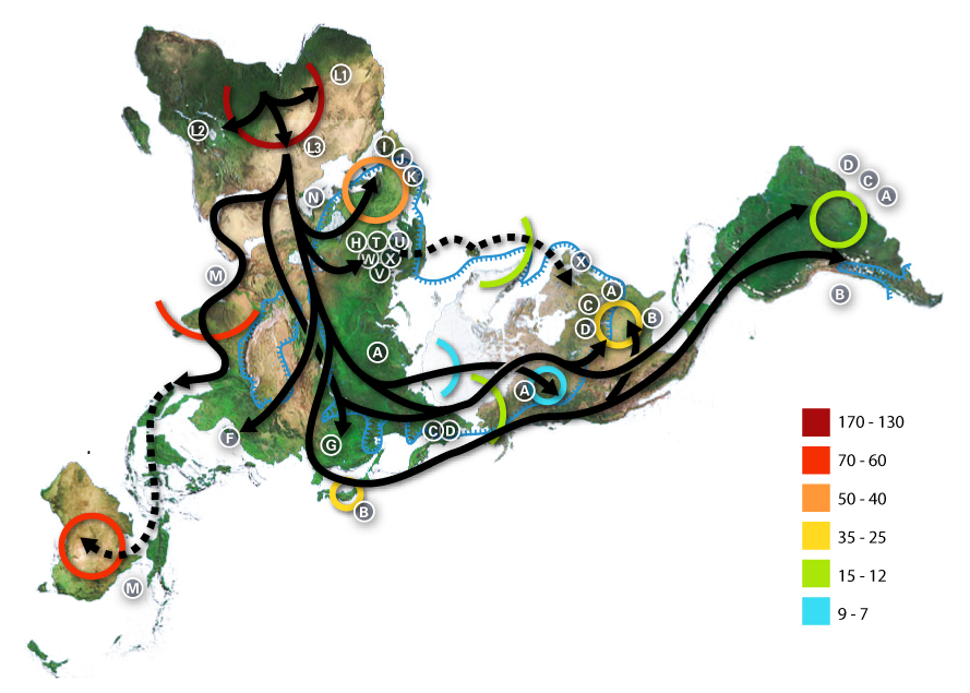
World map of human migrations, with the North Pole at center. Made in 2005.
Africa, harboring the start of the migration, is at the top left and South America at the far right. Migration patterns are based on studies of mitochondrial (matrilinear) DNA. Dashed lines are hypothetical migrations.
Numbers represent thousand years before present.
The blue line represents area covered in ice or tundra during the last great ice age.
The letters are the mitochondrial DNA haplogroups (pure motherly lineages); Haplogroups can be used to define genetic populations and are often geographically oriented. For example, the following are common divisions for mtDNA haplogroups:
- African: L, L1, L2, L3
- Near Eastern: J, N
- Southern European: J, K
- General European: H, V
- Northern European: T, U, X
- Asian: A, B, C, D, E, F, G (note: M is composed of C, D, E, and G)
- Native American: A, B, C, D, and sometimes X
- The letters I, J, K shown in Europe are apparently included by mistake, as they refer to Y-DNA haplogroups.
The dashed path for X, stopping in Iceland, gestures at the "Solutrean hypothesis", an idea discussed in the popular media at the time the map was made but mostly discredited since.
Data derivation
- Image:Northern icesheet hg.png shows the region that was covered by ice or tundra in the last ice age
- All migration data based on mitomap.
- Geographic data from File:Last glacial vegetation map.png
- and adding the following data File:Ice Age Temperature.png we get this interesting result File:Human-migration-temperature.jpg
Licenses

|
Այս վավերագրման պատճենահանման, տարածման և/կամ ձևափոխման թույլտվություն կամ լիցենզիայի GNU FDL պայմաններով 1.2 մեկնակերպի կամ ավելի ուշ, հրատարակված Ազատ ծրագրային ապահովության հիմնադրամում, առանց անփոփոխելի հատվածների, առանց բնագիրների, որոնք տեղադրված են առաջին և վերջին շապիկներում: Լիցենզիայի պատճենը գտնվում է GNU Free Documentation License հատվածում: |
| Այս նիշքը հասանելի է Creative Commons Attribution-Share Alike 3.0 Unported արտոնագրի ներքո: | ||
| ||
| Այս արտոնգրության հատկանիշը ավելացված է տվյալ նիշքին որպես GFDL արտոնագրի բարեփոխում: |
- Դուք ազատ եք՝
- կիսվել ստեղծագործությամբ – պատճենել, տարածել և փոխանցել այս աշխատանքը։
- վերափոխել – ադապտացնել աշխատանքը
- Պահպանելով հետևյալ պայմանները'
- հղում – Դուք պետք է նշեք հեղինակի (իրավատիրոջ) հղումը:
- համանման տարածում – Եթե դուք ձևափոխում եք, փոխակերպում, կամ այս աշխատանքի հիման վրա ստեղծում եք նոր աշխատանք, ապա ձեր ստեղծածը կարող է տարածվել միայն նույն կամ համարժեք թույլատրագրով։
Նիշքի պատմություն
Մատնահարեք օրվան/ժամին՝ նիշքի այդ պահին տեսքը դիտելու համար։
| Օր/Ժամ | Մանրապատկեր | Օբյեկտի չափը | Մասնակից | Մեկնաբանություն | |
|---|---|---|---|---|---|
| ընթացիկ | 01:54, 2 Հուլիսի 2015 | | 889 × 635 (274 ԿԲ) | Chronus | Reverted to version as of 03:10, 22 May 2012 |
| 18:00, 24 Հունիսի 2015 |  | 632 × 889 (295 ԿԲ) | SteinsplitterBot | Bot: Image rotated by 90° | |
| 03:10, 22 Մայիսի 2012 |  | 889 × 635 (274 ԿԲ) | 84user | Reverted to version as of 19:10, 12 August 2005 | |
| 23:30, 20 Մայիսի 2012 |  | 632 × 889 (295 ԿԲ) | Rotatebot | Bot: Image rotated by 90° | |
| 19:10, 12 Օգոստոսի 2005 |  | 889 × 635 (274 ԿԲ) | Avsa | ||
| 21:05, 5 Օգոստոսի 2005 |  | 536 × 380 (80 ԿԲ) | Stevertigo (usurped) | reupload with similar changes, but without compression/artifacts | |
| 21:00, 5 Օգոստոսի 2005 |  | 536 × 380 (30 ԿԲ) | Stevertigo (usurped) | altered brightness contrast - black/brown blending was distracting in last version | |
| 20:30, 17 Հուլիսի 2005 |  | 536 × 380 (110 ԿԲ) | Avsa | ||
| 18:08, 16 Հուլիսի 2005 |  | 745 × 380 (99 ԿԲ) | Avsa | Map of human races migration, according to the mithocondrial dna. All data based on mitomap http://www.mitomap.org/WorldMigrations.pdf I ignored all data I could not understand (for example a dotted line, the +/- and the letters). If someone explains to | |
| 18:03, 16 Հուլիսի 2005 |  | 745 × 380 (99 ԿԲ) | Avsa | Map of human races migration, according to the mithocondrial dna. All data based on mitomap http://www.mitomap.org/WorldMigrations.pdf I ignored all data I could not understand (for example a dotted line, the +/- and the letters). If someone explains to |
Նիշքի օգտագործում
Հետևյալ 2 էջերը հղվում են այս նիշքին՝
Նիշքի համընդհանուր օգտագործում
Հետևյալ այլ վիքիները օգտագործում են այս նիշքը՝
- Օգտագործումը af.wikipedia.org կայքում
- Օգտագործումը ar.wikipedia.org կայքում
- Օգտագործումը ba.wikipedia.org կայքում
- Օգտագործումը bn.wikipedia.org կայքում
- Օգտագործումը bs.wikipedia.org կայքում
- Օգտագործումը bxr.wikipedia.org կայքում
- Օգտագործումը ca.wikipedia.org կայքում
- Օգտագործումը cs.wikipedia.org կայքում
- Օգտագործումը da.wikipedia.org կայքում
- Օգտագործումը de.wikipedia.org կայքում
- Օգտագործումը de.wikinews.org կայքում
- Օգտագործումը de.wiktionary.org կայքում
- Օգտագործումը en.wikipedia.org կայքում
- Human evolution
- Wildlife
- Dymaxion map
- Talk:Human migration
- User:Avsa
- User talk:Truthteller
- Wikipedia:Reference desk/Archives/July 2005 II
- Genealogical DNA test
- User talk:Brian0918/Archive 07
- Haplogroup
- Talk:Human/Archive 16
- Haplogroup N (mtDNA)
- Haplogroup A (mtDNA)
- Haplogroup C (mtDNA)
- Haplogroup L3
- Human genetic variation
- Haplogroup Y
- Talk:Black people/Archive 11
- Portal:Maps/Maps/Thematic
- Portal:Maps/Maps/Thematic/1
Տեսնել այս նիշքի ավելի համընդհանուր օգտագործումը: