
Պատկեր:Western Han Mawangdui Silk Map.JPG

Նախադիտման չափ՝ 621 × 600 պիքսել։ Այլ թույլտվությաններ: 249 × 240 պիքսել | 497 × 480 պիքսել | 795 × 768 պիքսել | 1060 × 1024 պիքսել | 2121 × 2048 պիքսել | 3675 × 3549 պիքսել.
Սկզբնական նիշք (3675 × 3549 փիքսել, նիշքի չափը՝ 3,07 ՄԲ, MIME-տեսակը՝ image/jpeg)
Ամփոփում
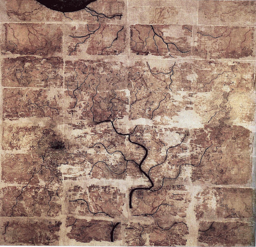
| Նկարագրում | A Chinese topographic map (with the south positioned at the top) from Mawangdui tomb 3; dated to the early Western Han period (183–168 BC); length is 96 cm; width is 96 cm; the map is made of ink on silk. It is now housed in the Hunan Provincial Museum, Changsha. The map depicts a large territory in southern China spanning from the imperial fiefdom of Changsha (a semi-autonomous kingdom within the Han Empire, now modern-day Hunan) to the independent and sometimes hostile Kingdom of Nanyue in what is now modern-day Guangdong and northern Vietnam. |
| Թվական | 2nd century BC (anywhere from 183 to 168 BC) |
| Աղբյուր | Scanned from Barbieri-Low, Anthony J. (2007). Artisans in Early Imperial China. Seattle and London: University of Washington Press. ISBN 0295987138. Page 174. |
| Հեղինակ | Anonymous ancient Chinese cartographer |
| Այլ մեկնակերպներ | Derivative works of this file: Cypraea mappa map comparison.jpg |
Արտոնագրում
|
Այս պատկերում գտնվող երկչափ ստեղծագործությունը հանրության սեփականություն է ամբողջ աշխարհում հեղինակի մահվան ժամանակի, կամ առաջի հրատարակման պատճառով:
Այսպիսով, տվյալ վերարտադրումը նույնպես հանրության սեփականություն է: Դա վերաբերվում է ԱՄՆ-ում, Գերմանիայում և ուրիշ բազմաթիվ պետություններում ստեղծված երկերին:
| ||||
Նիշքի պատմություն
Մատնահարեք օրվան/ժամին՝ նիշքի այդ պահին տեսքը դիտելու համար։
| Օր/Ժամ | Մանրապատկեր | Օբյեկտի չափը | Մասնակից | Մեկնաբանություն | |
|---|---|---|---|---|---|
| ընթացիկ | 22:58, 10 Մայիսի 2018 | | 3675 × 3549 (3,07 ՄԲ) | Soerfm | Brightness, color, crop. |
| 22:10, 27 Ապրիլի 2009 |  | 3675 × 3549 (2,89 ՄԲ) | PericlesofAthens | {{Information |Description=A Chinese topographic map (with the south positioned at the top) from Mawangdui tomb 3; dated to the early Western Han period (183–168 BC); length is 96 cm; width is 96 cm; the map is made of ink on silk. It is now housed |
Նիշքի օգտագործում
Այս նիշքին օգտագործող էջեր չկան։
Նիշքի համընդհանուր օգտագործում
Հետևյալ այլ վիքիները օգտագործում են այս նիշքը՝
- Օգտագործումը als.wikipedia.org կայքում
- Օգտագործումը ca.wikipedia.org կայքում
- Օգտագործումը de.wikipedia.org կայքում
- Օգտագործումը en.wikipedia.org կայքում
- Օգտագործումը es.wikipedia.org կայքում
- Օգտագործումը fi.wikipedia.org կայքում
- Օգտագործումը fr.wikipedia.org կայքում
- Օգտագործումը hr.wikipedia.org կայքում
- Օգտագործումը id.wikipedia.org կայքում
- Օգտագործումը it.wikipedia.org կայքում
- Օգտագործումը ja.wikipedia.org կայքում
- Օգտագործումը km.wikipedia.org կայքում
- Օգտագործումը ko.wikipedia.org կայքում
- Օգտագործումը mwl.wikipedia.org կայքում
- Օգտագործումը nl.wikipedia.org կայքում
- Օգտագործումը pl.wikipedia.org կայքում
- Օգտագործումը pnb.wikipedia.org կայքում
- Օգտագործումը pt.wikipedia.org կայքում
- Օգտագործումը ro.wikipedia.org կայքում
Տեսնել այս նիշքի ավելի համընդհանուր օգտագործումը: