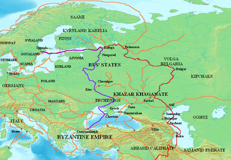
Պատկեր:Varangian routes.png

Նախադիտման չափ՝ 800 × 555 պիքսել։ Այլ թույլտվությաններ: 320 × 222 պիքսել | 640 × 444 պիքսել | 872 × 605 պիքսել.
Սկզբնական նիշք (872 × 605 փիքսել, նիշքի չափը՝ 859 ԿԲ, MIME-տեսակը՝ image/png)
Նիշքի պատմություն
Մատնահարեք օրվան/ժամին՝ նիշքի այդ պահին տեսքը դիտելու համար։
| Օր/Ժամ | Մանրապատկեր | Օբյեկտի չափը | Մասնակից | Մեկնաբանություն | |
|---|---|---|---|---|---|
| ընթացիկ | 11:29, 3 Հոկտեմբերի 2023 |  | 872 × 605 (859 ԿԲ) | OrionNimrod | Restore original: "Wallachians" added by Romanian user, however it was no Wallachia in the 8-11th c: British historian, Martyn Rady - Nobility, land and service in medieval Hungary (p91–93): the sources before the 13th century do not contain references to Vlachs anywhere in Hungary and Transylvania or in Wallachia. Byzantine sources mentioned Vlachs all deep in the Balcan. Also map should make by academic historians not by personal POV. |
| 18:23, 16 Օգոստոսի 2023 |  | 872 × 605 (799 ԿԲ) | Claude Zygiel | In one hand there are Byzantine sources which mention the Vlachs, secondly it is not because other sources do not mention them that they did not exist. In the other hand, the Hungarian theory which affirms that "the absence of proof is proof of absence", that this group disappeared for a thousand years, and that it would have been the only one, among all the peoples of the region , to not being able to cross the Balkans, the Danube and the Carpathians (while they were nomadic shepherds), is u... | |
| 10:54, 25 Հուլիսի 2023 |  | 872 × 605 (794 ԿԲ) | OrionNimrod | "Wallachians" added by Romanian user, however it was no Wallachia in the 8-11th c: British historian, Martyn Rady - Nobility, land and service in medieval Hungary (p91–93): the sources before the 13th century do not contain references to Vlachs anywhere in Hungary and Transylvania or in Wallachia | |
| 07:29, 26 Հունիսի 2023 |  | 872 × 605 (799 ԿԲ) | Johannnes89 | Reverted to version as of 16:47, 18 April 2023 (UTC) crosswiki image spam, often containing historical inaccuracies | |
| 23:53, 25 Հունիսի 2023 |  | 872 × 605 (1017 ԿԲ) | Valdazleifr | Fixed minor errors | |
| 16:47, 18 Ապրիլի 2023 |  | 872 × 605 (799 ԿԲ) | Claude Zygiel | There was no Wallachia but Wallachians. The theory that speakers of Eastern Romance languages disappeared for a thousand years between 275 and 1300 is only supported by Hungarian nationalist authors. | |
| 12:41, 25 Նոյեմբերի 2022 |  | 872 × 605 (794 ԿԲ) | OrionNimrod | Reverted to version as of 15:59, 8 March 2009 (UTC) It was no Wallachia in the 8-11th century | |
| 12:44, 21 Մայիսի 2015 |  | 872 × 605 (799 ԿԲ) | Spiridon Ion Cepleanu | Dvina & Wisla-Dnestr route, some details | |
| 15:59, 8 Մարտի 2009 |  | 872 × 605 (794 ԿԲ) | Mahahahaneapneap | Compressed | |
| 23:15, 18 հունվարի 2007 |  | 872 × 605 (859 ԿԲ) | Electionworld | {{ew|en|Briangotts}} == Summary == Map showing the major Varangian trade routes, the Volga trade route (in red) and the Trade Route from the Varangians to the Greeks (in purple). Other trade routes of the 8th-11th centuries shown in orange |
Նիշքի օգտագործում
Հետևյալ 2 էջերը հղվում են այս նիշքին՝
Նիշքի համընդհանուր օգտագործում
Հետևյալ այլ վիքիները օգտագործում են այս նիշքը՝
- Օգտագործումը af.wikipedia.org կայքում
- Օգտագործումը ar.wikipedia.org կայքում
- Օգտագործումը ast.wikipedia.org կայքում
- Օգտագործումը az.wikipedia.org կայքում
- Օգտագործումը be-tarask.wikipedia.org կայքում
- Օգտագործումը be.wikipedia.org կայքում
- Օգտագործումը bg.wikipedia.org կայքում
- Օգտագործումը ca.wikipedia.org կայքում
- Օգտագործումը ckb.wikipedia.org կայքում
- Օգտագործումը cs.wikipedia.org կայքում
- Օգտագործումը cv.wikipedia.org կայքում
- Օգտագործումը cy.wikipedia.org կայքում
- Օգտագործումը de.wikipedia.org կայքում
- Օգտագործումը el.wikipedia.org կայքում
- Օգտագործումը en.wikipedia.org կայքում
Տեսնել այս նիշքի ավելի համընդհանուր օգտագործումը:


