
Պատկեր:USA Territorial Growth 1850.jpg

Սկզբնական նիշք (1400 × 616 փիքսել, նիշքի չափը՝ 124 ԿԲ, MIME-տեսակը՝ image/jpeg)
| US growth maps |
| Animated: large · small |
| Years |
| 1775 · 1790 · 1800 · 1810 · 1820 · 1830 · 1840 · 1850 · 1860 · 1870 · 1880 · 1900 · 1920 |
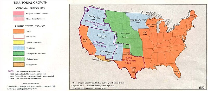
Map of U.S. Territorial Growth (1850) from the Perry-Castañeda Library Map Collection, "...the maps scanned by the University of Texas Libraries and served from this web site are in the public domain. No permissions are needed to copy them. You may download them and use them as you wish."
This image can be found at U.S. Territorial Growth 1850.
"Courtesy of the University of Texas Libraries, The University of Texas at Austin."
Other versions: 
|
This work is in the public domain in its country of origin and other countries and areas where the copyright term is the author's life plus 70 years or fewer.
| |
| This file has been identified as being free of known restrictions under copyright law, including all related and neighboring rights. | |
Նիշքի պատմություն
Մատնահարեք օրվան/ժամին՝ նիշքի այդ պահին տեսքը դիտելու համար։
| Օր/Ժամ | Մանրապատկեր | Օբյեկտի չափը | Մասնակից | Մեկնաբանություն | |
|---|---|---|---|---|---|
| ընթացիկ | 06:18, 4 Հոկտեմբերի 2005 | | 1400 × 616 (124 ԿԲ) | Lordkinbote~commonswiki | Map of U.S. Territorial Growth (1850) from the Perry-Castañeda Library Map Collection. This image can be found at [http://www.lib.utexas.edu/maps/united_states/us_terr_1850.jpg]. |
Նիշքի օգտագործում
Հետևյալ էջը հղվում է այս նիշքին՝
Նիշքի համընդհանուր օգտագործում
Հետևյալ այլ վիքիները օգտագործում են այս նիշքը՝
- Օգտագործումը ca.wikipedia.org կայքում
- Օգտագործումը de.wikipedia.org կայքում
- Օգտագործումը en.wikipedia.org կայքում
- Օգտագործումը es.wikinews.org կայքում
- Օգտագործումը it.wikipedia.org կայքում
- Օգտագործումը ja.wikipedia.org կայքում
- Օգտագործումը la.wikipedia.org կայքում
- Օգտագործումը nl.wikipedia.org կայքում
- Օգտագործումը no.wikipedia.org կայքում
- Օգտագործումը pl.wikipedia.org կայքում
- Օգտագործումը pt.wikipedia.org կայքում
- Օգտագործումը ro.wikipedia.org կայքում
- Օգտագործումը ru.wikipedia.org կայքում
- Օգտագործումը simple.wikipedia.org կայքում
- Օգտագործումը uk.wikipedia.org կայքում